

A wildfire in California’s Big Sur region was burning Saturday near the Pacific coastline and Highway 1, prompting evacuation orders, officials said. The blaze is the latest to threaten a region known for its iconic landscapes.
The Colorado Fire started Friday in Palo Colorado Canyon, a rural area in Monterey County, and had burned about 1,500 acres, said Michael Meddles, assistant chief with Cal Fire. It was 5 percent contained by Saturday afternoon.
A stretch of Highway 1 was closed in both directions because of the fire, which is located north of the Bixby Bridge, the California Department of Transportation said. The National Weather Service noted that photos posted to social media suggest there was “some pretty surreal fire behavior,” given recent wet conditions.
“Anecdotally it seems as though the long term drought is acting like a chronic illness where even recent rains and cold winter wx [weather] isn’t helping to keep fires from developing,” forecasters noted in an update.
It was unclear how many residents were affected by the evacuation orders. About 430,000 people live in Monterey County.
“The sheriff’s office went down there and moved everyone out,” Meddles said of the effort to get residents to safety in the affected area.
No injuries or deaths had been reported as of Saturday afternoon. The cause of the fire is under investigation.
Dry northeast winds pushed the fire toward Highway 1, according to the Weather Service. Forecasters had issued a wind advisory in the San Francisco Bay area for Friday night through Saturday morning, with meteorologists noting that stronger winds were more likely at higher elevations.
Cal Fire tweeted that the fire could be seen about 70 miles away in Santa Cruz County. Several agencies were responding to the blaze.

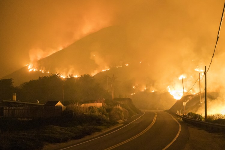
The Colorado Fire burns a fence off Highway 1 near Big Sur, Calif., Saturday. Nic Coury/Associated Press
Videos and photos shared to social media showed how the Colorado Fire remained largely unconfined along the scenic coastline early Saturday.
Some evacuees shared photos of the flames behind the Bixby Bridge, the legendary structure that spans the deep and wild canyon along Highway 1 and has been featured in TV shows and commercials. Meddles said that while the fire has moved south toward Bixby, the bridge is not being threatened by the flames.
The wildfire is the latest to burn across California in the past year. The Dixie Fire was the second-largest in California’s history and the biggest to burn in the United States last summer, as climate change turbocharged severe storms, floods and fires. More than 1,300 structures were leveled, causing government agencies to spend about $540 million to battle the blaze. The Dixie Fire burned nearly 1 million acres, an area larger than New York City, Chicago, Dallas and Los Angeles combined.
California’s shifting weather patterns have presented new threats to Highway 1, a California spectacle that features stunning beauty along its 650-mile route.
One of the most serious blazes in recent years was the 2016 Soberanes Fire along Highway 1 just south of Carmel-by-the-Sea, about 75 miles outside of San Jose. The fire burned nearly 60 homes and killed a bulldozer operator, and it was among the most expensive fires to fight in state history at the time.
The Colorado Fire broke out on the same day that Vice President Kamala Harris visited her home state to announce that California would be receiving $600 million in recovery funds for the U.S. Forest Service in the state.
“As a daughter of California, I know the devastation that wildfires bring,” she wrote on Twitter.
Jim Shivers, a spokesman with the California Department of Transportation, said there was no estimated time for reopening Highway 1.
George Nunez, an assistant fire chief with Cal Fire’s San Benito-Monterey unit, told the Mercury News that the blaze “made a run through the canyons” after it aligned with fast-moving winds.
“It moved surprisingly fast for a fire around this time of year,” Nunez said. “We had a little bit of moisture and it was cold last night, but because of the winds it burned along the slope, catch another wind and then blew in another direction.”
The state has experienced exceptional drought, which brought moisture levels in California’s forests to historic lows, as well as searing heat. Recent rains have helped reduce some of the drought in the state.
Humidity levels in the area are in the teens and wind gusts are around 35 mph, according to the Weather Service.
More than 1,000 customers with PG&E, the state’s public utility, were experiencing power outages from Los Padres National Forest to Carmel as of late Friday, KRON reported.
The Red Cross has set up a shelter at Carmel Middle School, officials said. The Society for the Prevention of Cruelty to Animals also announced that it is providing emergency pet supplies at the shelter.
The Weather Service said a wind shift Saturday was expected to push some of the smoke and haze from the Colorado Fire toward the Monterey Peninsula and Salinas.
Meddles praised the efforts of first responders and said more work was needed to figure out how to contain the blaze along Highway 1.
Send questions/comments to the editors.

Success. Please wait for the page to reload. If the page does not reload within 5 seconds, please refresh the page.
Enter your email and password to access comments.
Hi, to comment on stories you must . This profile is in addition to your subscription and website login.
Already have a commenting profile? .
Invalid username/password.
Please check your email to confirm and complete your registration.
Only subscribers are eligible to post comments. Please subscribe or login first for digital access. Here’s why.
Use the form below to reset your password. When you've submitted your account email, we will send an email with a reset code.