

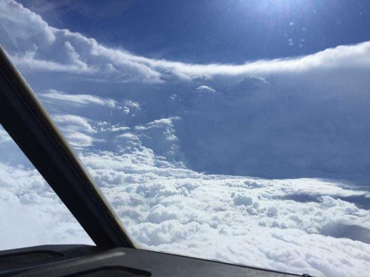
Hurricane Ida was personal for Air Force pilot Kendall Dunn. The Category 4 storm – the strongest Atlantic hurricane to make landfall last year – was barreling toward his family’s home in southern Louisiana. He wondered if he had purchased enough gas for his family and told his nephew to evacuate. But as his loved ones drove away from the storm, he steered a plane toward its center.
Dunn is part of a five-person crew – known as “Hurricane Hunters” – onboard the WC-130 Hercules aircraft that flies into storms to gather data on wind speeds, pressure and moisture.
While satellites in space are one of the main methods for monitoring hurricanes, direct aircraft observation helps forecasters better determine the storm’s potential growth, structure and effects on land. Their data combined with satellite observations also feed models, which project the storm’s path and intensity.
The aircraft data has played a key role in recent forecast improvements while aiding progress made in communicating storm hazards to the public.
But it takes the plane’s crew to gather the data. Hurricane hunters are tasked with flying through the most extreme conditions of the planet’s most powerful storms.
“When you get in close to the eyewall, the most intense part, you definitely can feel the forces against the aircraft, the turbulence, the up and down, the lightning,” Dunn said. “We’re flying that for about 2 minutes, the most scary part and nobody wants to be in.”
As Dunn and his co-pilot flew through Ida’s violent eyewall, the flight meteorologist in the back of the aircraft helped navigate them around the weather and into the rain-free eye.
As the plane reached the center, data on their position was relayed to forecasters at the National Hurricane Center within a minute. A few minutes later, more details were sent, including the speed of the strongest winds at flight level (around 10,000 feet), the speed of surface winds around the eye and the lowest pressure reading.
“When you get in that center, it’s beautiful, it’s calm. It’s kind of a chance to take a break real quick before you go back in the other side,” Dunn, who has been a hurricane hunter for the past decade with the Air Force’s 53rd Weather Reconnaissance Squadron, said. He previously flew Black Hawk aircrafts in the Army before he “made the switch to this crazy job.”
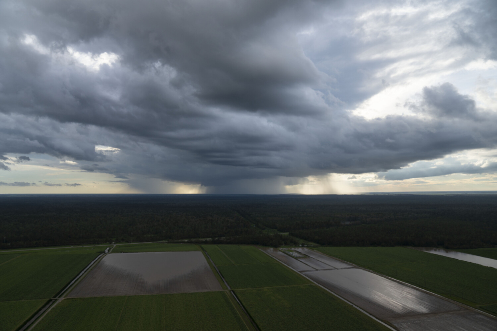
A rain squall passes over the wetlands in southern Louisiana during Hurricane Ida, on Aug. 30, 2021, in Houma, La. Michael Robinson Chavez/The Washington Post
By locating the eye, forecasters on the ground can determine how far threatening winds extend from the center – important factors for storm intensity and surge. For a behemoth like Ida, which caused $75 billion in damage and took nearly 100 lives, the information was critical. Without accurate forecasts, the toll would have probably been far worse.
“Hurricane Ida was potentially one of the boldest forecasts in our history,” Ken Graham, director of the National Hurricane Center, said. “We had enough confidence in the data we were getting from the aircraft and enough confidence in the models to [predict it would become] almost a major hurricane on the very first advisory. That never used to happen.”
Over the past few years, Graham and his colleagues have been faced with new and unprecedented situations: more rapidly intensifying hurricanes, a record number of storms, and a global pandemic. In response, they have made some of their best forecasts – and new advances – armed with data from hurricane hunters and satellites. Yet challenges remain.
FORECASTS FOIL DEADLY STORM SURGES
Chris Dyke has flown into countless storms in his 13 years of service as a hurricane hunter, but he vividly remembers his first flight over a Category 4 storm off the coast of Cuba.
“I remember looking out of the window and seeing the wind actually physically pushing the water. You see the wind creating these swells in the ocean as the water’s about to make its way on the land. That shocked me,” Dyke, an aerial reconnaissance weather officer on the Air Force’s 53rd Weather Reconnaissance Squadron, said.
Dyke was staring at one of the largest causes of hurricane fatalities at the time: storm surge. The surge is the storm-driven rise in ocean water above normally dry land at the coast, typically caused by a storm’s winds pushing water onshore. Sometimes topping 20 feet, it can completely inundate a coastal community. Nearly 90 percent of fatalities associated with hurricanes are tied to threats from water; storm surge historically accounted for half of that.
Today, though, improved surge forecasts and concerted public outreach have lowered that number to a mere 3 percent; from 2017 to 2021, more people died of carbon monoxide poisoning than storm surge.
It is “the biggest thing we’re proud of,” Jamie Rhome, deputy director of the National Hurricane Center, said.
In 2017, the Hurricane Center began to implement new watches and warnings specifically for storm surge, creating inundation maps and upgrading storm surge models. Many of the models and warnings were improved because of the data obtained from the hurricane hunters, Rhome said. In addition to the Air Force, the National Oceanic and Atmospheric Administration also has a crew of hurricane hunters and operates two aircraft that fly into storms.
“We’re seeing instantly how the wind is changing. This turns out to be really, really important for refining the surge forecast, but also getting the wind watches and warnings very, very, very precise,” Rhome said. “Say you’re shaving 50 miles off of a hurricane watch, that could be an entire county not included in a watch area.”
Rhome also said they increased lead time for storm surge forecasts by 20 percent to 2-1/2 days in 2021, giving emergency managers more time to prepare. He said the Hurricane Center plans to increase the lead time by 12 more hours for the 2023 hurricane season.
“That may not seem like a lot to the casual observer, but 12 hours is an eternity in emergency management,” Rhome said. “Emergency managers need longer lead times to make these difficult decisions about evacuation. Those lead times shot up even more with the covid pandemic because of all the logistics they had to deal with.”
INLAND FLOODING BECOMES TOP STORM HAZARD
As storm surge fatalities decreased, inland flooding became the deadliest storm hazard. “It’s the leading cause of fatalities in tropical systems since 2017,” Graham said.
For Hurricane Ida, more than half of the deaths occurred from drowning and flash flooding as its remnants trekked across the Northeast.
Several factors contributed to the severity of Ida’s deluge, such as record-breaking rainfall intensity, boosted by human-caused climate change. Furthermore, several of the cities affected were not designed to handle such extreme downpours. The torrents completely overwhelmed the infrastructure of New York City.
But much of the damage also stemmed from inaction by the public, Graham said. Although Ida was relatively well-forecast, the public response to the watches and warnings issued was inadequate, he said, not unlike the societal response to storm surge before 2017.
“We do have products from the Weather Prediction Center that outline medium to high risk of flash flooding. We have to take that as serious as tornadoes and hurricanes because we’re losing so many lives,” Graham said. “The more we talk about it, the better we’ll get used to that product … and be able to take actions with it.”
The Hurricane Center is involved in nine social science projects that explore how to help the public better interpret forecasts and take appropriate action. The projects include how the public uses the Hurricane Center website, understands track forecast graphics and interprets probabilities and percentages.
Graham said one finding from the research is that people will often read an initial storm forecast but not check subsequent updates; researchers call this “anchoring.” A consequence of anchoring is that if the forecast changes, these people will be potentially misinformed. Graham said this shows that people need to be reminded to stay updated, but it also underscores the importance of that first forecast.
That’s why making a bold initial forecast for Ida was important.
As researchers predict an active 2022 hurricane season, NOAA will triple its supercomputing capacity to support higher-resolution models that can inform more accurate first forecasts.
Hurricane hunters are also gearing up.
“We use all those models and forecasts (from the National Hurricane Center) as well to move our own planes and move our family,” Dunn said. “My family’s dependent on me.”
Send questions/comments to the editors.

Success. Please wait for the page to reload. If the page does not reload within 5 seconds, please refresh the page.
Enter your email and password to access comments.
Hi, to comment on stories you must . This profile is in addition to your subscription and website login.
Already have a commenting profile? .
Invalid username/password.
Please check your email to confirm and complete your registration.
Only subscribers are eligible to post comments. Please subscribe or login first for digital access. Here’s why.
Use the form below to reset your password. When you've submitted your account email, we will send an email with a reset code.