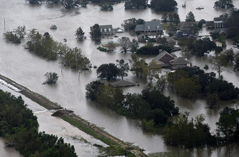
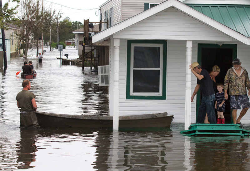
A weakened Isaac continued to wreak havoc along the Gulf Coast on Thursday as the slow-moving storm crept northward toward drought-parched states at just 9 mph.
The water Isaac dumped did far more damage than its winds, which petered out at 40 mph Thursday. Isaac has produced as much as 25 inches of rain and a storm surge of 6 to 12 feet.
At the Louisiana-Mississippi border, officials ordered 60,000 residents to evacuate when a dam threatened to break at Lake Tangipahoa in Mississippi, about 100 miles northwest of New Orleans, while rescue crews used helicopters and boats to reach hundreds more stranded by flooding in southern Louisiana and parts of Mississippi.
At least two storm-related deaths have been reported, in Vermilion Parish, La., and in Picayune, Miss.
“This is still a life-threatening situation in some areas,” said Rich Serino, the deputy administrator of the Federal Emergency Management Agency.
Isaac made landfall as a Category 1 hurricane in southern Louisiana on Tuesday night, became a tropical storm Wednesday and was downgraded to a tropical depression Thursday. But National Hurricane Center Director Rick Knabb warned that the terminology didn’t capture the seriousness of the dangers that Isaac still posed.
“That does not mean the event is over,” Knabb said. “For some people, it is just beginning.”
Flooding already has forced more than 4,700 people into shelters and left more than a million without power, said Charley Shimanski, the senior vice president of disaster services for the Red Cross.
“The hazard from this storm is still very real,” Shimanski said. “One need only look at the satellite imagery to see that this is a very slow tropical storm hammering communities across the Gulf Coast.”
Perhaps hardest hit was low-lying Plaquemines Parish in Louisiana, where National Guard troops and private citizens rescued 140 people and evacuated a nursing home, Gov. Bobby Jindal said at a news conference.
President Obama issued a major disaster declaration late Wednesday for 35 parishes in Louisiana and 34 counties in Mississippi that Isaac has swamped.
The move will help with the removal of downed power lines, tree branches and other debris, but FEMA officials couldn’t say how soon teams will arrive on the ground to help residents process their storm-related claims. Preliminary damage assessments must be completed first, they said.
The remnants of Isaac’s heavy rains should arrive in the parched Midwestern states Friday, starting with Arkansas and Missouri.
“The numbers look encouraging: 2-4 inches across a good portion of the state,” said Pat Guinan, state climatologist for Missouri.
“By no means is it going to eliminate the drought conditions, but it is a step in the right direction,” Guinan said.
The welcome downpour probably will come too late to save the dying corn crop, however, said David Miskus, a meteorologist with NOAA’s Climate Prediction Center.
“The damage is already done for corn,” Miskus said.
But soybeans might benefit. “Soybeans are more heat- and drought-tolerant if they were planted later than normal,” he said. “These rains could actually help the soybeans fill the pods.”
Slow and steady rain for a day or two will do the most good to soften the ground and help the soil recharge from the drought, he said.
“It will help; it’s just not clear exactly how much,” Miskus said.
Cleanup began in earnest Thursday across some parts of the Gulf Coast even as rain continued to fall. In coastal Mississippi, parts of U.S. 90 remained closed, but casinos reopened.
Still, emergency managers prepared for nearby rivers to crest at the highest levels seen in recent memory. The Biloxi River was expected to crest overnight Friday at 19 feet — 7 feet above flood stage.
Send questions/comments to the editors.


Success. Please wait for the page to reload. If the page does not reload within 5 seconds, please refresh the page.
Enter your email and password to access comments.
Hi, to comment on stories you must . This profile is in addition to your subscription and website login.
Already have a commenting profile? .
Invalid username/password.
Please check your email to confirm and complete your registration.
Only subscribers are eligible to post comments. Please subscribe or login first for digital access. Here’s why.
Use the form below to reset your password. When you've submitted your account email, we will send an email with a reset code.