
SCARBOROUGH and SOUTH PORTLAND – There are two big dig projects coming to the area this fall, and while one might easily go unnoticed by the public, the other will be right out in the open.
Beginning in November, the federal government will pay $3.5 million to dredge the Scarborough River and another $16 million to clear the main shipping channel in the Fore River, from Veterans Memorial Bridge to South Portland’s Bug Light at the mouth of Casco Bay. Apart from the need to relocate about 3,000 lobsters, work in South Portland to move about 600,000 cubic yards of material will likely draw little attention.
“When people see the dredge out in the river, folks will say, ‘I wonder what that is?’ because it’s a fairly good-sized vessel,” said South Portland Transportation Director Tom Meyers. “But otherwise it’s a lot like sewer work – you don’t fully appreciate what needs doing until things aren’t right, and when the work is over, you can’t see what’s been done.”
‘Man-made problem’
In Scarborough, however, work will be much more visible. Whereas material dug up from the Fore River will be hauled out to sea, the 150,000 cubic yards of sand to be taken from the Scarborough River will be used for “nourishment” of Western Beach, to restore piping plover habitats and to rebuild dunes that washed away three weeks ago, causing two of the 18 holes at the Prouts Neck Country Club to be lost to the sea, at least temporarily.
The dune breach has been a long time coming, according to Jim Fisher, president of Northeast Civil Solutions, hired a decade ago to help the Prouts Neck Association deal with beach erosion issues.
According to Fisher, a stone jetty built “with the best of intentions” in the late 1950s by the U.S. Army Corps of Engineers to act as a wave break has actually accelerated erosion problems, which the Prouts Neck Association has largely been powerless to stop because of state environmental laws.
“Unfortunately, the people at the time didn’t understand the continued hydraulic action of the ocean,” said Fisher. “It would have been very easy several years ago to be able to augment that dune with a series of engineered steps, but the laws of the state of Maine don’t allow that. Those laws are environmentally conscious and restrictive to the point where the association has been unable to maintain what’s was already there.”
What was there, before the jetty was built, said Fisher, was a sand dune that ran from “the rock at Prouts Neck” up the river to Ferry Beach. That dune is now largely gone because of tidal action altered by the jetty.
Today, he said, two fairways at the golf course are “inundated with salt water” while some spots have sand deposits up to three feet deep.
Although it may be hyperbole, the joke, said Fisher, is that continued wave action created by the jetty, exacerbated by rising tides and increased storm surges, could eventually pinch off the narrow link Prouts Neck has to the mainland, turning the gated community into an island.
“The thinking at the state, essentially, is let nature take its course,” said Fisher. “That’s all well and good, but this is not a natural occurrence. It’s a man-made problem.”
Continued shoaling at the Scarborough River does not just affect the rich and famous. In 2009, not long after Town Manager Tom Hall came to town, he got a visit from Charlie Gray, a local fisherman who moored near Ferry Beach. Continued in-fill had made it so that that, at low tide, Gray’s boat was very nearly landlocked.
The Army Corps has been aware of that problem and since April 2010 has had a project planned to remove 125,000 cubic yards of material at a cost of $2.8 million.
“I’ve been in communication with them ever since,” said Hall. “The problem is, there’s never been money available. But on a hunch, or a lark really, I picked up the phone again when I saw media coverage of the Hurricane Sandy cleanup.”
Hall said he asked the corps to check if Scarborough might he eligible for funds under the $17 billion Disaster Relief Appropriations Act.
“To our great surprise and delight, sure enough we did qualify,” he said.
Last week, Maine’s U.S. senators, Susan Collins and Angus King, issued a joint statement announcing that Scarborough had been approved for $3.5 million under the Supplemental Appropriations Act signed into law by President Obama in January.
Although funding is limited to areas most affected by Hurricane Sandy, and likely won’t be approved to dredge as far up as Ferry Beach, the combination of Sandy’s surge and perennial shoaling caused by the jetty has been self-evident.
“It’s really dramatic,” said Hall. “At low tide you can walk from Pine Point Beach almost to the Prouts Neck Yacht Club. It’s interesting, a lot of people do that and then have to scurry back quickly when the tide comes back in.
“It’s really an issue for navigation right now. It’s getting tougher and tougher to get a channel you can come and go from,” said Hall.
“If the channel fills in, the river will find a way to get to the ocean somehow and there are populations on either side that could be impacted,” said Fisher.
As in South Portland, the Scarborough River dredging will happen between Nov. 1 and March 15, 2014. However, the Army Corps needs to conduct an updated survey of the river bottom before work can begin, said Hall.
Only time will tell, said Fisher, if enough sand can be put in place to protect the country club in the future. Similar work was done in 2005, he noted, but eventually, the dune was breached just the same.
“This will undoubtedly benefit them,” said Hall, “but it also, frankly, makes it cheaper for us, because if the Army Corps does not have an easy, convenient place to deposit these spoils they need to haul it out to an at-sea dump location. That means time and money.”
Dredging the Fore
In South Portland, the channel was last cleared in 1999 and, according to the Army Corps, natural shoaling has filled some areas of the channel to 33 feet, which “may impede deep draft commercial vessels,” such as oil tankers, cargo vessels and cruise ships. The channel depth was set nearly two centuries ago at 35 feet by the federal River and Harbor Act of 1836.
In addition to dredging, a contractor, yet to be determined, also will remove five rock ledge pinnacles located roughly between Chandler’s Wharf and the Centerboard Yacht Club in South Portland. However, the corps says the underwater blasting needed to remove these ledges will be “barely perceptible at the surface.”
“This isn’t like the depth charges you see in old movies,” said Meyers. “There won’t be anything to see other than maybe a small ripple at the surface.”
In all, about 600,000 cubic yards of material will be removed from the bottom of the river and dumped in an area covering one square nautical mile, located 7.1 miles east of Dyer Point in Cape Elizabeth, used for that purpose since 1982.
According the corps, its Disposal Area Monitoring System study “shows that the site is a low energy environment, such that sediment deposited at this location will remain within the site’s boundaries.”
Something that will move from its boundaries, however, at least temporarily, are the lobsters that call the shipping channel home. The corps plans to “sequence” work to minimize the impact on the bottom-feeders, but about 3,000 lobsters will eventually have to be moved. The Portland Board of Harbor Commissioners will manage that project at a cost of about $90,000. That price tag will be split evenly between Portland, South Portland and the Maine Department of Transportation.
South Portland’s $30,000 portion will be taken in equal parts from its undesignated fund balance and unused reserve funds as part of the 2014 Capital Improvement Projects budget approved Monday by the City Council.
“This really isn’t about the lobsters,” said Meyers. “It’s about the continued economic viability of the port and the region. Unfortunately, the work that needs to be done isn’t ‘sexy.’ So, it doesn’t really get a great many advocates.”
Still, it is important to the project that the lobster relocation efforts proceed as expeditiously as possible. According to the Army Corps, it’ll cost the project $100,000 every day that a dredge the size of the one slated to work Portland Harbor sits idle.
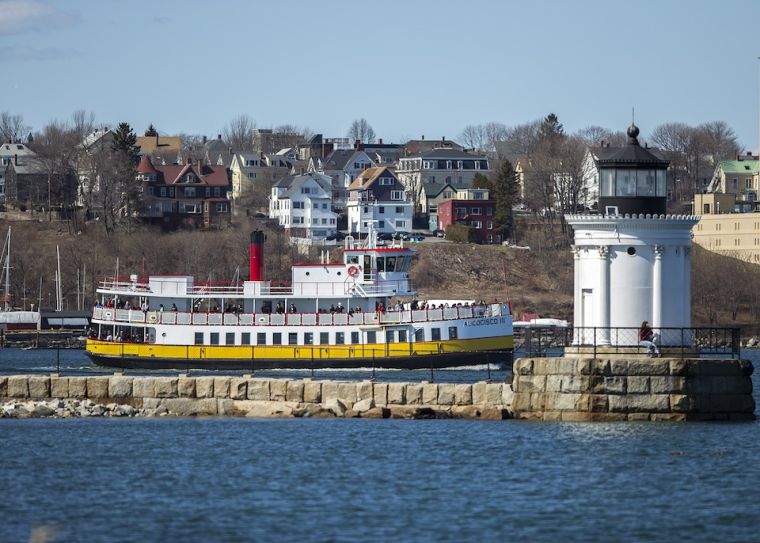 In one of two large dredging projects slated for this fall, the Fore River, from Bug Light in South Portland, above, to the Casco Bay Bridge, will be cleared for the first time since 1999. The Scarborough River, too, will be dredged, with 150,000 cubic yards of sand to be moved to Scarborough’s Western Beach. Both projects recently received federal funding. Photo by Rich Obrey
Comments are no longer available on this story