
With about a month until spring, I thought this would be a good time to look at the final stretch of winter and what we might expect. With the exception of the brief Arctic blast, it’s been a mild winter, especially compared to last year. Temperatures continue to take wild swings and this will be the case once again this week.
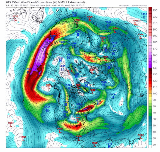
Weather is nature’s attempt to balance the atmosphere, and it does so by moving air masses around the globe. As these air masses interact, they produce storms. The loop of the jet stream over the next 10 days really gives you a sense of this flow. What you are looking at is the speed of the wind at around 30,000 feet. At this level, we can get a good understanding of how temperature and precipitation will evolve during this period. The wind speed key is on the right. Winds over the Pacific Ocean are moving at over 200 mph in this loop.
There’s a great deal of atmospheric noise that contributes to the chaos of weather. It’s amazing that we can predict it as well as we do in spite of the many variables. I want to show you several of these variables – and how they help predict the weather in the coming days and weeks.
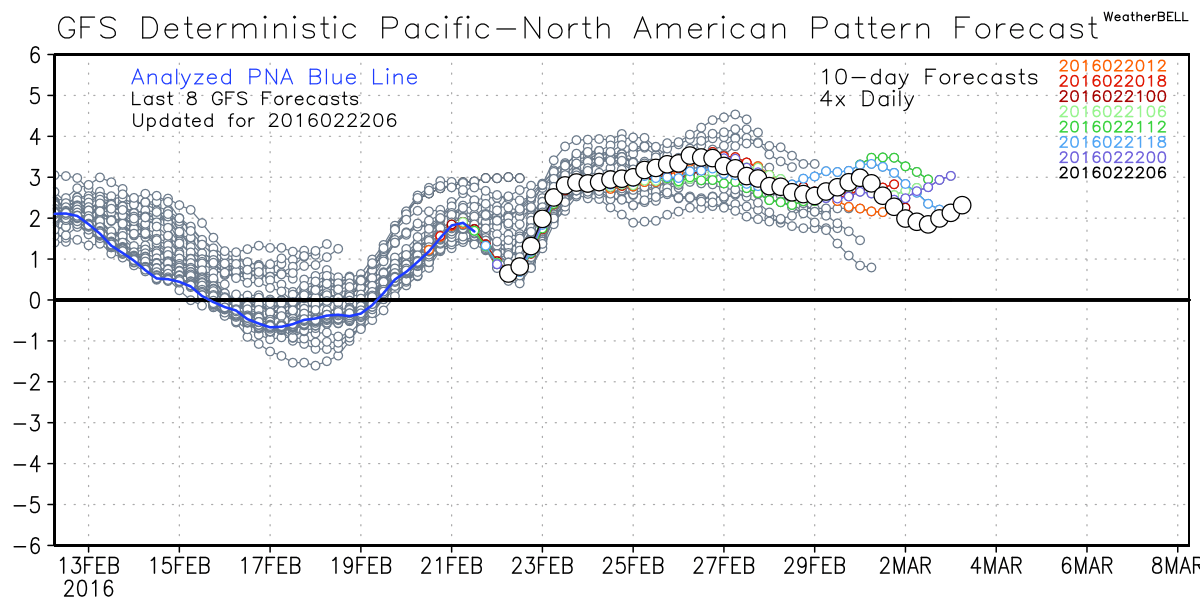
Pacific North American Pattern (PNA):
The PNA measures the dip and bulge in the jet stream across North America. When this pattern is positive, it tends to favor a colder and stormier East and a drier and warmer West. The PNA is forecast to be positive in the coming week, putting pressure on more storms here. This is an important reason why our weather will remain cold and somewhat unsettled starting in March. This may be the dominant reason for the cold forecast starting this weekend.
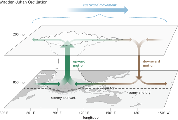
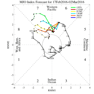
Madien-Jullian Oscillation (MJO):
The MJO is a measurement of thunderstorm clusters traveling along the equatorial regions in the Pacific Ocean.
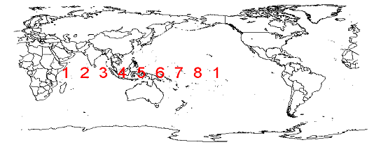
These clusters of storms influence the subtropical jet stream as they move eastward. There are eight positions, or phases, the storms can be in. Presently, the storms are forecast to remain in the warmer phases in New England.
This image shows the MJO upcoming prediction:
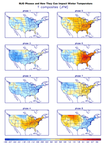
The different phases and how they impact North America are below.
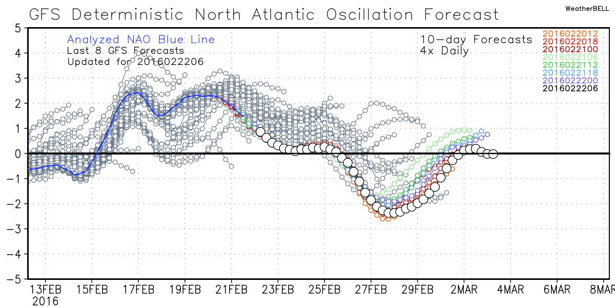
North Atlantic Oscillation (NAO):
The NOA is another very influential index that, when in a negative phase, can bring stormy and cold weather to New England. When it’s in the positive phase, storms can certainly still occur, but they tend to move along faster and not become blocked. The NAO is forecast to remain positive in the short term. While it may turn briefly negative as we close out the month, it won’t be excessively so. This doesn’t bode well if you want a blockbuster snowstorm that lasts a day or more.
What Does It All Mean?
Of course, these aren’t the only three indices that help guide our forecasting. El Nino is still present as a backdrop, providing additional heat to the atmosphere. For the next three weeks, with the atmosphere in these various states, there is certainly pressure for a return to cold. Snow is much more difficult to forecast. A storm track difference of 100 miles can mean shoveling or not. I do think the next two weeks are critical if ski areas are going to build any sort of natural base heading into spring. The good news for snow making is cold weather should be consistent beginning this weekend.
Last fall, many meteorologists were predicting this winter would be relatively and without prolonged freezing temperatures or snow. That forecast is holding steady as we head into the home stretch.
Please follow my weather feed on Twitter @growingwisdom
Comments are no longer available on this story