


“A stunning stretch of blue sky as far as I can see” – that’s my forecast for the next several days and beyond. We are locked in a blocking pattern where the weather gods are smiling down on central and southern Maine. The jet stream is stuck in a position such that storms will not be able to penetrate into the area and therefore sunshine and eventually a few days of warm weather are in the offing.
Meteorologists call the present jet stream configuration an omega block. This blocking pattern takes on the shape of the Greek letter omega and is depicted in the image below where the flow in the atmosphere resembles this: Ω.
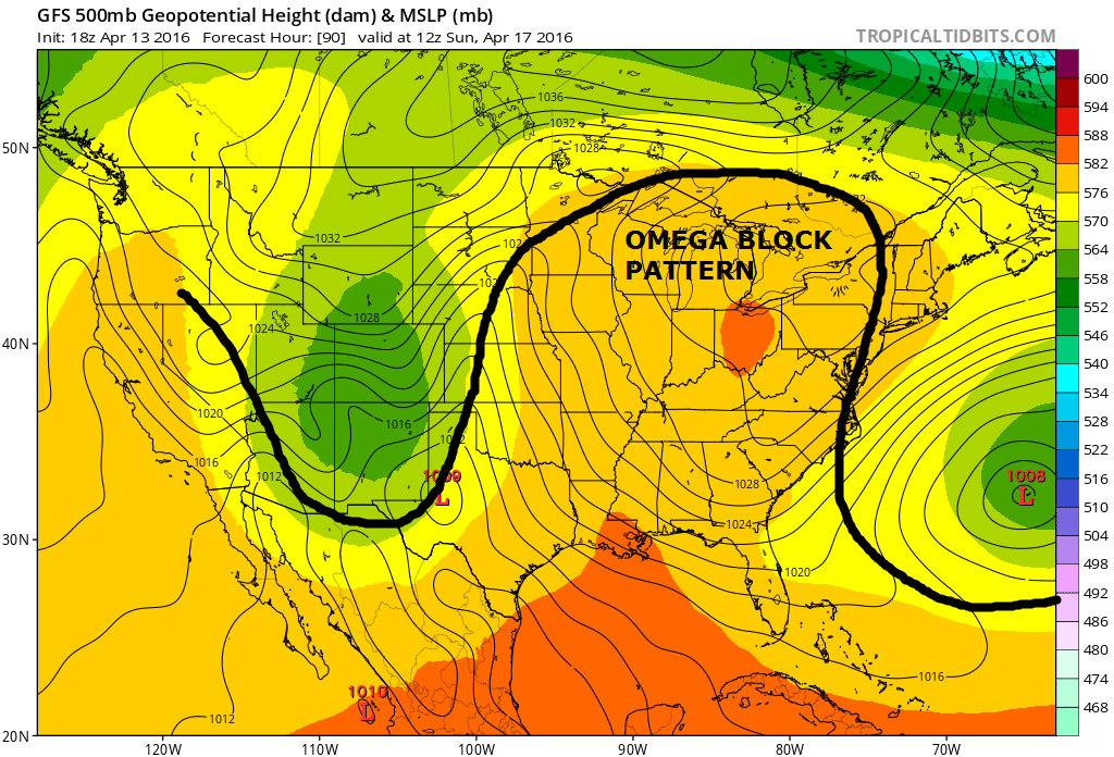
Omega Block Pattern In The Jet Stream
It’s not always sunshine and tranquil weather in these blocks. The block has three parts, low pressure, then high, then low again. If New England were influenced more by the low pressure sides we’d have clouds and precipitation
Check out the forecast for the next 5 days. How often do we see so many days of sunshine in April?

Southern Maine Forecast
Now look at what’s going on in parts of Colorado, which is also under the influence of the omega block, but the inclement side of it.
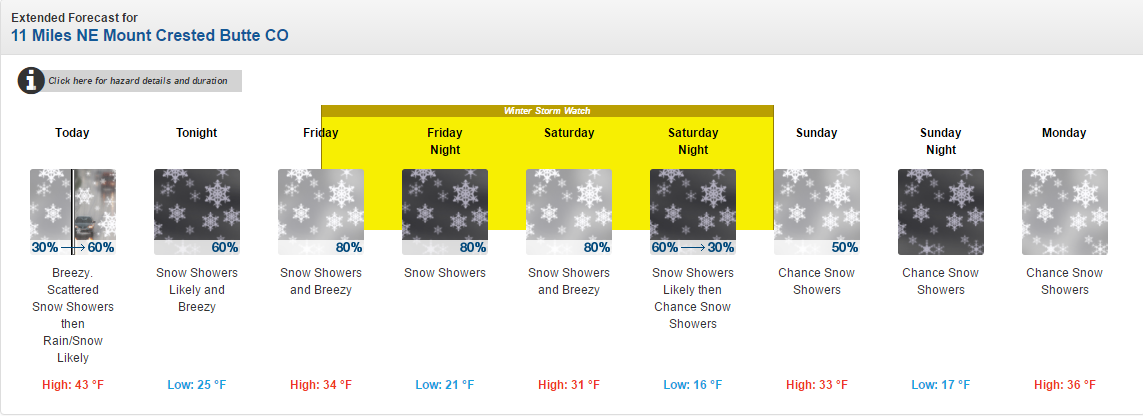
Rocky Mountain Snow
Spring is typically when these stuck jet streams set up. The atmosphere is in deep transition from its winter mode to summer. In the readjustment process things can get stuck.
While the block is slow to move, it’s not in the exact same position every day. There will be some changes heading into the weekend and early next week. First a surge of warm air brings temperatures into the lower to middle 60s for Sunday and likely Monday as well. Some spots over the interior of York and Cumberland counties could reach 70 degrees.
MARATHON MONDAY
Since Monday is a holiday you might be joining the thousands of runners and spectators heading for Boston. Monday will begin cool for the runners, but quickly warm up. If the sea breeze never materializes, then from about 11 a.m onward temperatures will be between 65 and 72 degrees, quite warm for running, but nearly ideal for spectators.
A cold front with marine air on the other side of it will make its way south Monday night and Tuesday bringing colder air and returning temperatures to seasonable levels from above average ones. While there will be a frontal passage it will likely come with nothing more than clouds. The spell of dry weather will resume next week with the next chance of significant rain perhaps as long as 10 days from now. That’s about the time I’ll start getting nervous about the prospects for summer drought.
Copy the Story Link
Send questions/comments to the editors.

Success. Please wait for the page to reload. If the page does not reload within 5 seconds, please refresh the page.
Enter your email and password to access comments.
Hi, to comment on stories you must . This profile is in addition to your subscription and website login.
Already have a commenting profile? .
Invalid username/password.
Please check your email to confirm and complete your registration.
Only subscribers are eligible to post comments. Please subscribe or login first for digital access. Here’s why.
Use the form below to reset your password. When you've submitted your account email, we will send an email with a reset code.