
SEBAGO LAKE – One look at the threatening sky above and James Sinko, a meteorology student on vacation at Sebago Lake State Park last weekend, knew conditions over Sebago Lake Sunday afternoon were ripe for something spectacular.
And the heavens didn’t disappoint as a funnel cloud formed near Point Sebago Resort in Casco on the eastern shore and sat there churning for about 8 minutes, Sinko said.
Sinko, a student at Lyndon State College in Vermont, captured the rotating funnel cloud with his camera phone at 1:28 p.m. and then alerted John Jensenius at the National Weather Service office in Gray. Jensenius confirmed the funnel cloud and immediately issued a weather advisory for the area.
While funnel clouds, which Jensenius estimated had a rotating wind speed of between 40-60 mph, are rare in Maine, the Sebago Lake funnel was Sinko’s second such sighting in less than two weeks. He saw another funnel cloud while visiting a school friend in Corolla, N.C. on July 20.
Sinko, of Brunswick, had been swimming at the day-use section of Sebago Lake State Park, “in the rain like a true Mainer,” he said, when he noticed the sky darkening.
“I noticed it when I was in the water and started to see this very small line of very fast rotating clouds and then began to drag more clouds into the rotation. It was getting dark as the rain shower got closer. [It was an] amazing experience,” Sinko said.
Jensenius, the warning coordination meteorologist at the National Weather Service in Gray, explained that a funnel cloud doesn’t make landfall. When a funnel touches down over land, it’s described as a tornado. And when a funnel forms over water and touches down on the surface, it’s described as a waterspout.
Jensenius said the funnel cloud over Sebago Lake on Sunday never touched down, “but it was very close,” he said.
Jensenius said a shear zone had formed over Sebago Lake Sunday, which provided optimal conditions for a rotating cloud formation to take shape. On the ocean side of Sebago Lake, winds were out of the southwest while inland the winds were coming out of the northeast, “so there was kind of a shearing motion which when combined with the fact that we had a shower developing over the area, caused that rotation to spin up,” Jensenius said.
Jensenius said waterspouts have formed over Sebago Lake in the past. However, with handheld consumer technology like the smartphone used by Sinko to capture and email images of the funnel, the weather service is getting more documented cases thanks to perceptive observers like Sinko.
“We’re seeing more and more of these because people have cell phones and other equipment they can take photos with. So we seem to be seeing more of these things,” Jensenius said, adding, “If people see funnel clouds, we’d appreciate they call in.”
Sinko said there were boats in the area on Sunday but not directly below the cloud formation. Jensenius said boaters need not worry “as long as the funnel is up in the air. But if it does come down and either forms a waterspout or tornado, yes, it is dangerous, but it depends on how strong it is.”
In Maine, Jensenius said waterspouts and funnels can pack wind speeds in excess of 100 mph with tornadoes packing even more rotational wind speed.
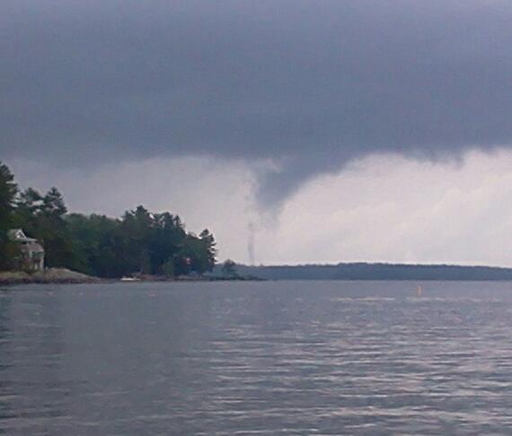 James Sinko, of Brunswick, captured a photo of a funnel cloud over Sebago Lake on Sunday afternoon with his smartphone and then notified the National Weather Service in Gray, which issued an advisory.
Comments are no longer available on this story