


Earlier this month I wrote about what type of weather you could expect this summer. Most predictions were looking at a hotter-than-average summer, and while the verdict on rainfall was not as clear, drought was a definite possibility.
Predictions in May called for a warmer than average summer (June-August). A few weeks later, we haven’t had any significant prolonged heat or humidity, and the wind of the past several days has made it feel almost fall-like – especially in the evenings and early mornings.
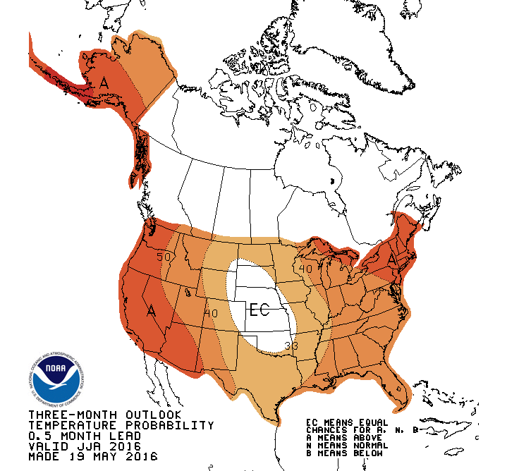
Mid-May prediction for June-August temperatures
This latest pattern may prompt you to wonder if the forecast for a hot summer might turn out wrong. While I haven’t seen any forecasters changing the outlook for the summer, it’s entirely possible the entire summer ends up cooler than average. But it’s not likely.
Having the first couple of weeks in June ending with average or slightly below-average temperatures doesn’t mean the entire summer is going to be a chilly one. The jet stream will continue in a position that keeps the comfortable air in place here in the Northeast and keeps the heat out West. This configuration is very similar to February 2015, when many spots in New England experienced their coldest month on record.
Since it’s June and the sun is so strong, a jet stream pulling air from Canada keeps the heat away, but without the bone-chilling cold.

Cool jet stream pattern for Maine
Early summer doesn’t predict the entire summer
It’s also important to keep in mind the forecast of a warmer-than-average summer includes the period June through August. We could end up with average June and July temperatures, then experience blockbuster August heat, for an overall summer that’s warmer than average. These predictions don’t necessarily mean it’s going to be three straight months of record-breaking heat.
In the same way a mild December can be followed by a cold and snowy January and February, a June with near-normal temperatures doesn’t mean the same thing for July and August. So far in Portland, temperatures are actually averaging almost exactly at the 30-year normal – which might be surprising considering the recent cool mornings.
Ocean temperatures are a big player
The two aspects of the global ocean temperatures to keep an eye on this summer are the developing La Nina – where there was an El Nino present just a few months ago – and the cool pool of water in the north Atlantic. Each of these will likely have an impact on the global temperature and precipitation patterns this summer, and more so into the fall and winter. I am personally interested in that cool pool over the Atlantic, and wonder if that could keep New England cooler than many are forecasting. If the summer isn’t very hot, that may be one of the reasons.

Current ocean temperature anomaly
Still no big heat for a while
The next 8-14 days continue to focus most of the heat west of New England. Late this weekend and during the week of June 20 some heat and humidity will be trying to move closer to the area. It remains a bit of a question if this heat will make it into Maine or not. For those of you wanting to sit on the beach and bake in the sun, you’ll need a bit more patience. I’ll be updating the pattern on Twitter @growingwisdom

8-14 day outlook as of June 14th.
Send questions/comments to the editors.

Success. Please wait for the page to reload. If the page does not reload within 5 seconds, please refresh the page.
Enter your email and password to access comments.
Hi, to comment on stories you must . This profile is in addition to your subscription and website login.
Already have a commenting profile? .
Invalid username/password.
Please check your email to confirm and complete your registration.
Only subscribers are eligible to post comments. Please subscribe or login first for digital access. Here’s why.
Use the form below to reset your password. When you've submitted your account email, we will send an email with a reset code.