

Pleasant Mountain, stretching over about 4 miles on the north-south Bridgton-Denmark line, is the highest peak in southern Maine – and reveals itself in dramatic fashion. Traveling west along Route 302 from Bridgton, the trees part around Moose Pond and the northern and eastern slopes of Pleasant Mountain fill your view.
Shawnee Peak Ski Area dominates the northern face, and it’s easy to see why somebody would want to put a ski area there: Wide trails, long cruisers and twists through the woods all seem to flow over easy-to-intermediate grades, bathed in the sun all morning. No wonder there’s been a ski area operating on Pleasant for more than 80 years.
But this special mountain is much more than a home to Maine’s longest-operating ski area. While skiing is what originally brought me to Pleasant, I’ve fallen in love with the mountain year round. Here you can find some some of the best hiking and snowshoeing this side of the White Mountains – and it’s only about an hour from Portland.
Loon Echo Land Trust oversees the management of a 10-mile trail network on the mountain, with two trailheads on the eastern side in Bridgton and two trailheads on the western side in Denmark. All the trails are open for four-season hiking, and each route to the summit offers unique challenges and features. That’s just another way of saying that every single one of these trails is worth hiking, so get ready to return time and again.
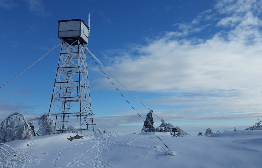
Your ultimate goal will probably be the mountain’s flat, open main summit. At just 2,006 feet, Pleasant is less than a third the height of nearby Mt. Washington, but because of the relatively flat surrounding land, the views from the top are stunning. The White Mountains – including Washington, prominently – roll off to the north and west while Denmark, Fryeburg and the Saco River Basin stretch below. Before Pleasant hosted a ski area, the summit was home to a hotel from 1873 to 1907, giving it the name “House Peak.” The hotel is long gone and a boarded-up Maine Forest Service fire tower now stands in its place.
The Ledges Trail (1.8 miles; trailhead is three miles from Route 302 on Mountain Road) is the shortest trail to the summit and the most popular route up Pleasant’s eastern side. The trail begins at an easy grade through the woods, traveling along an old logging road and crossing a couple of streambeds before following switchbacks to climb rapidly. At the halfway point you gain the ledges that give the trail its name, with wonderful views of Moose Pond and Pleasant’s southwestern summit. The rest of the trail climbs steeply in places but for me, this last stretch passes quickly – the views are too distracting to notice my sore muscles.
The Southwest Ridge Trail (2.7 miles; trailhead is 3.5 miles from Route 160 on Denmark Road) is a quiet, striking route that travels over the mountain’s 1,900-foot southern peak. After just a half-mile of gradual climbing on an old road, the trail swings sharply onto open ledges, where the trees thin to offer open views for most of the way to the southwest summit. At just 1.6 miles, this lesser peak is worth a trip in its own right; there’s plenty of powder to break on the ridge in winter, and the rocks are loaded with blueberries in the summer. While it’s the longest trail to the main summit, it provides views of Moose Pond, Beaver Pond and Long Pond that are hard to find elsewhere.
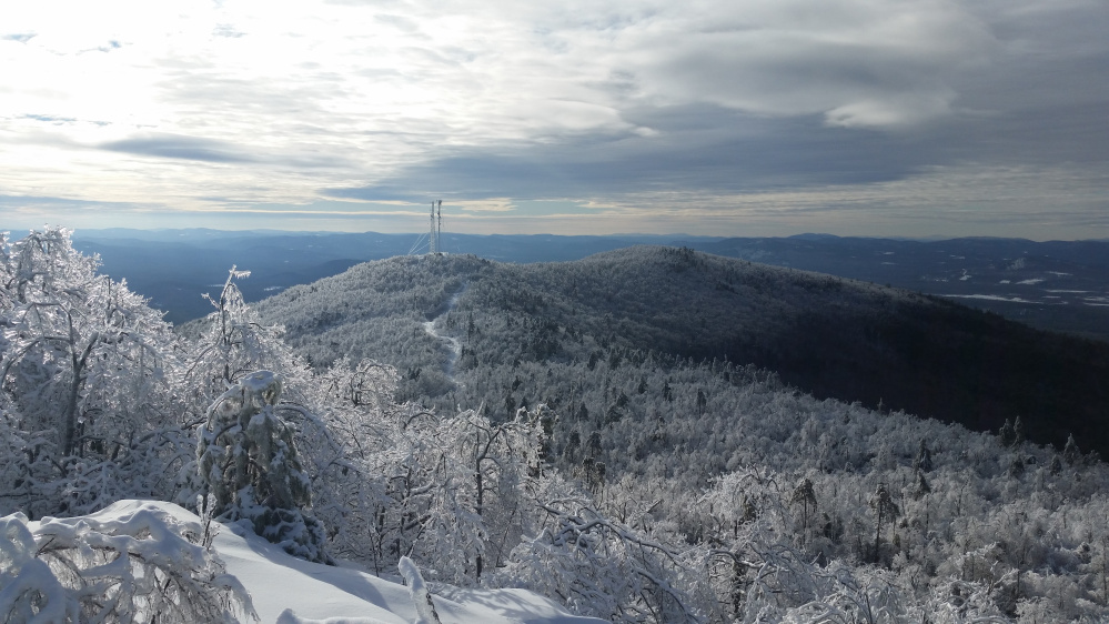
Bald Peak Trail (2.2 miles; trailhead is 1.8 miles from Route 302 on Mountain Road) is a more challenging route to the top, passing over 1,932-foot “Big Bald Peak” on the way. The trail climbs quickly along small brooks, which create a number of beautiful cascades in the spring – including the particularly striking Needle’s Eye, accessible via a short spur. At 0.7 miles, the trail splits; bear left to continue toward Big Bald, or stick to the right on Sue’s Way to add Pleasant’s northernmost peak (1,905 feet) and another 1.5 miles to your route. After about a half-mile of very steep climbing on Bald Peak Trail, you’ll reach the rocky summit of Big Bald, where there are excellent views in all directions. The trail continues easily for 1.2 miles over the crest of the ridge, and joins the Firewarden’s Trail just below the summit.
While the Firewarden’s Trail (2.3 miles; trailhead is 1.2 miles from Route 302 on Wilton Warren Road) lacks the scenery of the other trails, it offers something they don’t – a wide, easy trek with no scrambling and just 1,500 feet of elevation gain. The first half of the trail is along an old road, still used as a snowmobile trail in the winter, and it doesn’t really start to climb steadily for more than a mile. When it does start to gain major ground, it does so with wide swings on a broad trail that lacks any really tricky terrain, all the way to the junction with the Bald Peak Trail just below the summit. A good choice for families and an ideal snowshoe route in the winter.
Jake Christie is a freelance writer living in Portland. Along with his brother, Josh, he writes about great Maine destinations for outdoors enthusiasts. Jake can be reached at:
jakechristie@gmail.com
Copy the Story LinkSend questions/comments to the editors.

Success. Please wait for the page to reload. If the page does not reload within 5 seconds, please refresh the page.
Enter your email and password to access comments.
Hi, to comment on stories you must . This profile is in addition to your subscription and website login.
Already have a commenting profile? .
Invalid username/password.
Please check your email to confirm and complete your registration.
Only subscribers are eligible to post comments. Please subscribe or login first for digital access. Here’s why.
Use the form below to reset your password. When you've submitted your account email, we will send an email with a reset code.