

Looking at most weather maps, the storm system that swept through the mid-Atlantic and New England on Wednesday and Thursday was nothing to write home about. But in a 350-mile swath from north central Pennsylvania to New Hampshire, a staggering 30 to 45 inches of snow fell.
The extreme snowfall is noteworthy both for its sheer quantity and the speed at which it fell. Snowfall rates nearing a half foot per hour at times accompanied the heaviest snow bands, the system vastly overperforming compared with forecasts.
Peak snowfall totals topped 40 inches in four states: Pennsylvania, New York, Vermont and New Hampshire.
A number of records were set, including what is potentially Pennsylvania’s greatest 24-hour snowfall, 43.3 inches in Alba, a small town in the north central part of the state.
Despite the exceptional snow, there were next to no power outages associated with the wintry wallop, save about 30,000 ice-related outages in Virginia. While vehicles were buried and roadways disappeared beneath feet of snow across at least four states, the electricity stayed on.
The secret to the storm’s record-breaking but low-impact snowfall? Refrigerated air, both at the surface and at the mid levels of the atmosphere- – –
Nowadays, it’s hard to get through the winter without hearing terms such as “bombogenesis” thrown around, describing the rapid intensification of an area of low pressure and subsequent strengthening into a powerful storm. Such meteorological “bombs” are usually responsible for most of the Northeast’s blockbuster storms.
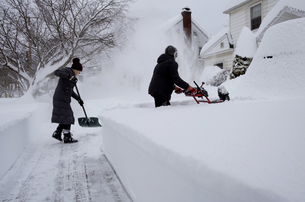
Susan Iannuzzi, left and Linda Marzell of Binghamton, N.Y., clear a sidewalk after a heavy snowfall on street in Binghamton, N.Y., Thursday, Dec. 17. Binghamton Airport reported 39.1 inches of snow and another spot in Binghamton reported 41.0 inches, according to the National Weather Service. AP Photo/Craig Ruttle
Wednesday’s storm didn’t “bomb” out; in fact, it was a rather weak system. But it had plenty of moisture to work with, contributing to a localized zone of extreme snowfall.
“The four to five inch an hour rates observed in this event are extremely rare,” wrote Alex Lamers, a meteorologist at NOAA’s Weather Prediction Center. “It’s even more rare to sustain such snowfall rates for several hours (about 5 hours in this case).”
That meant that some places such as the National Weather Service office itself in Binghamton, N.Y. picked up 20 inches between 1 a.m. and 6 a.m. Thursday.
Overall, Binghamton wound up with 40 inches, a record two-day amount, while Newark Valley, N.Y. had 44. Binghamton’s snowfall was 16 inches more than the Weather Service’s high-end forecast.
The likely record snowfall is an event that will undoubtedly be studied for years to come. And while most meteorologists weren’t expecting three and a half feet of snow, it’s easy to find a few factors at play in retrospect. At work was more than just a boatload of moisture; temperature proved to be everything.
Anyone who has shoveled snow knows that not all snow is created equal. Some is heavy, wet and sludge-like, while others can be a light, dusty powder.
Snow in Wednesday’s and Thursday’s ripping band fell amid cold temperatures in the teens and lower 20s, allowing for a fluffier consistency that stacked up quickly.
“The warmer the temperature, the more likely there will be supercooled water (liquid water at temperatures below freezing) that ‘sticks’ (refreezes) to the snowflake,” Lamers explained via email. “This makes snow more dense.”
That’s why, at temperatures near freezing, the snow is likely to be thicker, sloppier and stickier. That wasn’t the case during this storm.
“Temperature and moisture also affect the natural structure of snowflakes,” Lamers wrote. “It turns out the ‘fluffiest’ snowflakes (called “dendrites”) commonly form with high humidity and temperatures between zero and 10F.”
During the height of the snow in Binghamton, the temperature hovered between 15 and 16 degrees, with dew points – a number that corresponds to how much moisture is in the air – at 12 or 13 degrees. That meant the air was frigid but also nearly saturated, the perfect recipe for dry fluffy snow.
Between 10 and 20 degrees, snowflakes tend to take the form not of a six-pointed caricature star, but rather hexagonal prisms or columns. Sometimes they’re hollow. With a lesser density, they stack up taller.
At temperatures close to freezing, an inch of liquid water may correspond to eight or 10 inches of snow. But in Binghamton, 2.8 inches of liquid equivalent yielded 40 inches of snow – a 14.3 to 1 times snow to water ratio.
In Springfield, in central Vermont, temperatures were also in the midteens with high relative humidity, while Lebanon, N.H. stayed below 17 degrees the whole time.
Wind, or the lack thereof, was also cooperative in an airy, fluffy snowfall.
“Wind can create stresses that fracture snowflakes as they fall, making them smaller and more dense as they reach the ground,” wrote Lamers.
But winds were generally light, less than 10 to 15 mph as the fierce snow band raged, allowing the snowflakes to lazily saunter downward and settle on the ground.
In Binghamton, Springfield and Lebanon, the snow came down heavily enough that visibilities remained at or below a quarter mile for six hours or more. Ordinarily, such low visibility would require heavy snow and winds topping 35 mph; the fact that visibility dropped so low without strong winds or blowing snow attests to the fury of the snowfall.
All those factors helped the snow that fell to accumulate into hefty amounts. But what triggered the lone, stubborn snow band to begin with? The answer also lies in temperature, but at the mid levels of the atmosphere.
Between roughly 5,000 and 10,000 feet, a sharp temperature gradient, or change with horizontal distance, existed over the northern Appalachians. That so-called “frontogenesis” acted akin to a cold front, as the focal mechanism to lift the air and squeeze moisture out of it.
That band didn’t move much with time; instead, it pivoted as the instigating storm system swept northeast offshore of New England.
In addition, some stretching at the mid levels due to converging air, called “deformation,” helped enhance upward lift in the lower atmosphere. This stretching, or pulling apart of air at the mid to upper levels, has a vacuum-like effect; air is forced to rise from below to fill the newly-created void. That, combined with other factors, helped kick the snow band into overdrive.
Copy the Story LinkSend questions/comments to the editors.

Success. Please wait for the page to reload. If the page does not reload within 5 seconds, please refresh the page.
Enter your email and password to access comments.
Hi, to comment on stories you must . This profile is in addition to your subscription and website login.
Already have a commenting profile? .
Invalid username/password.
Please check your email to confirm and complete your registration.
Only subscribers are eligible to post comments. Please subscribe or login first for digital access. Here’s why.
Use the form below to reset your password. When you've submitted your account email, we will send an email with a reset code.