

California has had one of its driest January and February periods on record, with little to no precipitation in many places.
After a very promising start to the water year, precipitation has essentially flatlined during what should be the wettest two months of the year – months that are critical to drought improvement. The extreme dry spell also marks an abrupt shift from an extremely wet and snowy December 2021.
San Francisco, San Jose, Eureka, Sacramento, Fresno, Los Angeles International Airport and parts of the Sierra Nevada all recorded their driest January to February period on record, with many Southern California locations in the top five driest.
Sacramento saw no measurable precipitation during February and Tuesday will break its record for the longest dry stretch during the wet season of 52 days, which was set during the winter of 2013-14. It’s the city’s third extended dry period in the last decade. This comes on the heels of California’s longest streak without precipitation during the dry season: 211 days from March 20 to Oct. 16, 2021.
San Jose had 54 straight days without rain, from Dec. 29 to Feb. 21 – its longest winter dry streak with records dating to 1893. The city saw only 0.01 inches of rain in the last two months.
Downtown San Francisco had no rain for 44 consecutive days, its second-longest on record.
The missing moisture is reminiscent of February 2020, an extremely dry month in which some Northern California stations recorded zero rainfall, kick-starting the current drought.
This winter’s dry spell is particularly concerning because it is enveloping the wettest parts of the state that are crucial for water supply.
Mountain snowpack is now well below normal for the date at 64 percent – almost exactly where it was at this time last year. While atmospheric rivers in October, November and December provided most of the precipitation that has fallen since the water year began on Oct. 1, the storm track shifted north in early January and has yet to return.
Instead, the state has seen wind, a record-breaking heat wave, and only occasional light precipitation over the last two months, thanks to a persistent ridge of high pressure that has blocked moisture from the Pacific.
“The systems that we’ve had have been very weak, especially for January and February,” said Cory Mueller, a meteorologist with the National Weather Service in Sacramento. “It was almost a fall-like pattern with weather systems passing just to the east of California.”
Barring a series of late-season storms during spring, the wet season looks likely to end with below average precipitation, with drought remaining or even worsening as the state enters its months-long dry season.
Jeanine Jones, interstate resources manager with the California Department of Water Resources, said that statewide precipitation is currently 80 percent of average, which would mark a third consecutive dry year for Northern California and a second for Southern California without significant additional rain and snow.
“Frankly, March will really be a make-or-break month, especially for Northern California,” she said. “If we have a really wet March, there is a chance we can come out pretty much near normal.”
Long-range forecasts aren’t promising a “Miracle March,” although a shift to a wetter pattern is possible around mid-month, according to the National Weather Service in San Diego.
Lake Shasta, the state’s largest reservoir, sits at only 37 percent of its total capacity because of light water-year precipitation in the Sacramento River basin.
Last week, water districts that supply Central Valley farms learned that they would receive no water for the second year in a row from the Central Valley Project, a water storage and conveyance system managed by the federal government, with Lake Shasta as its backbone.
“That’s significant not just for agricultural water users but also more broadly for the area in which they are located,” Jones said.
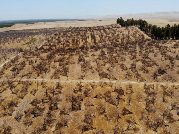
Without irrigation water, farms may overdraw groundwater, leading to dry wells and land subsidence, both of which the state experienced last summer. Lake Shasta’s low water levels are also a concern for the region’s salmon, which rely on reservoir releases to maintain optimal water temperatures downstream.
But California isn’t the only state that has missed major winter storms. Much of the West has been dry for the last two months. Large swaths of Oregon, Nevada, Arizona, New Mexico, Montana, Utah and Colorado are below average for the water year and remain mired in drought. In fact, the only drought-free spots in the Western U.S. are western Washington and the northwestern corners of Oregon and Montana.
Last week’s U.S. Drought Monitor placed portions of Northern California and southern Oregon back into the “extreme drought” category, the second most severe category of drought.
“Without a major pattern change during March, additional degradations may be needed for California and the Great Basin in the weeks ahead,” the Drought Monitor stated.
This year’s precipitation extremes in California and the West, combined with long-term drought, are consistent with what is expected with climate change. A study released last month found that the 2000-2021 was the most severe drought period in the Western U.S. in 1,200 years, due in large part to human-caused climate change.
And Monday’s report from the Intergovernmental Panel on Climate Change noted: “North American water resources continue to be affected by ongoing warming, with impacts driven by reductions in snow and ice, increases in extreme precipitation, and hotter droughts.”
Send questions/comments to the editors.

Success. Please wait for the page to reload. If the page does not reload within 5 seconds, please refresh the page.
Enter your email and password to access comments.
Hi, to comment on stories you must . This profile is in addition to your subscription and website login.
Already have a commenting profile? .
Invalid username/password.
Please check your email to confirm and complete your registration.
Only subscribers are eligible to post comments. Please subscribe or login first for digital access. Here’s why.
Use the form below to reset your password. When you've submitted your account email, we will send an email with a reset code.