

Homes on Gross Loop off Kentucky Route 15 are flooded by the swollen North Fork of the Kentucky River on July 28. Arden S. Barnes/For The Washington Post
Like an unhinged seesaw, this summer’s rainfall has teetered between too much and too little across the United States. Record-high rainfall in pockets of the country brought unprecedented flooding; meanwhile, other communities yearned for just a few drops as droughts worsened.
Weather patterns have always brought variable rainfall across the country, but this summer featured a new era of extreme precipitation events brought on by a warming world: wet events are becoming wetter, and dry events are becoming drier.
“(A) striking feature on the weather maps this summer has been the relatively close proximity of extreme heat events to extreme rainfall events, as well as the number of these events,” said Greg Carbin, the chief of the Forecast Operations Branch at NOAA’s Weather Prediction Center, in an email. “You’d expect perhaps one, or the other, but this summer we’ve seen both.”
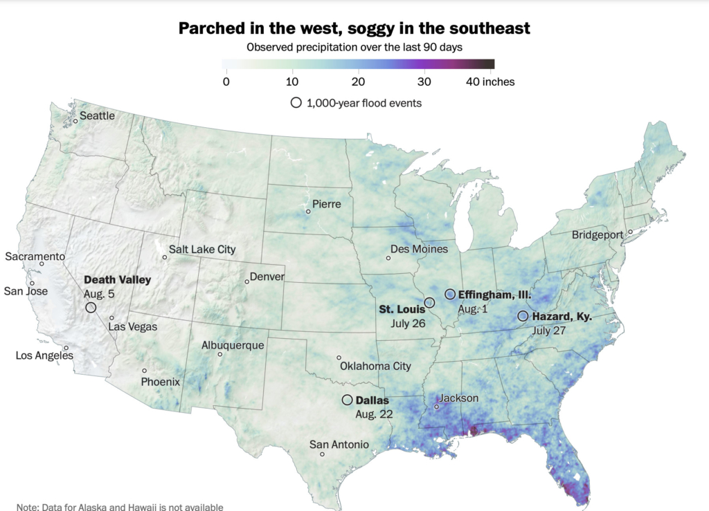
Much of the United States has experienced significantly below average or above average rainfall; very few places are on par with long-term average precipitation amounts, as shown in the map above of rainfall deviations from normal.
This summer, the most notable precipitation deviations from normal occurred in the southwestern United States, which received around 100 to 150 percent more rain than its long-term average amounts because of an active monsoon season.
The Southwest monsoon is a seasonal wind shift that brings moisture from the Gulf of Mexico and Pacific Ocean into the Southwest and parts of Southern California. Thunderstorms during monsoon season can deliver up to 50 to 70 percent of the region’s total rainfall. This year, the monsoon started in mid-June, about two weeks earlier than normal, and continued.
“Probably the most interesting feature to me was the reincarnation of the (S)outhwest monsoon this year, which led to numerous flood hazards in the parched southwestern U.S.,” wrote John Abatzoglou, a climate scientist at the University of California at Merced, in an email.
For instance, heavy rain at Carlsbad Caverns National Park in southern New Mexico trapped 200 people for several hours until officials rescued them. Twice in about two weeks in late July and early August, floodwaters poured into casinos in Las Vegas as the city received its largest amount of monsoon rain in a decade.
Carbin added that the monsoon pattern helped break all-time monthly rainfall records near the Arizona-New Mexico border. “In fact, there are locations in this region that have experienced monthly rainfall amounts during July and August that have not been previously observed in at least the past 50 years.”
A seating area is encircled by floodwater in the area of the Trinity River near downtown Dallas on Aug. 22. Emil Lippe/For The Washington Post
The summer’s most devastating rain events were spread across the Southwest and the central states, in which record downpours produced a season’s worth of rain in a single day. The most notable single-day rainfall occurred in St. Louis, western Kentucky, eastern Illinois, Death Valley, Calif., and Dallas. All five rainfall events were exceptionally rare, estimated to have only a 0.1 percent probability of occurring in any given year.
The torrents of rain triggered serious flooding that engulfed communities, damaged infrastructure and prompted emergency rescues. Thirty-eight people died in the rain event in western Kentucky, and at least one person died in the flooding in Dallas.
Several other areas also experienced unusual and serious rain events. In June, 2 to 3 inches of rain fell in Yellowstone National Park and melted snow, triggering historic flooding and landslides and sweeping away roads and homes. Near-record rainfall in Jackson, Miss., on Aug. 24 knocked out the city’s primary water treatment plant, leaving some neighborhoods without running water.
“Summertime thunderstorm downpours have been especially intense this year,” said Daniel Swain, a climate scientist at the University of California at Los Angeles. “It is precisely the kind of extreme precipitation that we expect to increase the most in a warming climate.”
In recent years, a larger amount of rain in the United States has come in the form of intense single-day events. Data shows that nine of the top 10 years for extreme one-day precipitation have occurred in the past three decades.
Swain said the gradual warming of the atmosphere has increased the frequency of such extreme single-day events. A warmer atmosphere can “hold” more water; the atmosphere can hold approximately 4 percent more water for each extra degree Fahrenheit of warming. Since 1979, average temperatures in the United States have risen between 0.32 and 0.55 degrees Fahrenheit degrees per decade.
But while extreme precipitation events logged impressive rainfall rates, they are not large enough to compensate for the large expanses of drought. Swain said that in addition to the low precipitation, a warmer atmosphere is driving more evaporation from the ground, worsening drought conditions.
The western United States, especially California, is the most noticeable drought-stricken area in the country. The drought is mostly due to the recent lack of winter rain and snow as well as to rising temperatures, which are hastening evaporation.
By itself, Abatzoglou said, California’s paltry summer rain isn’t too alarming, since typical summer precipitation “is next to nothing.” A healthy round of storms and snowfall in the fall and winter could put a dent in the drought, although full recovery is likely to take several years.
Yet, a lack of summer precipitation has severely affected the Northeast. Boston experienced its fourth-driest July on record. Only about a half an inch of rain fell in Providence, R.I., in July, about 2.5 inches below average. Drought conditions stretched between New Jersey and coastal Maine.
Much of the Central and Southern Plains also experienced limited rainfall and well-above-normal temperatures, during which drought expanded and intensified.
As of Aug. 30, around 65 percent of the country was experiencing abnormally dry to exceptional drought conditions.
“The generally smaller footprint of these extreme rainfall events has been offset by widespread drought,” NOAA’s Carbin wrote in his email. “… My own analysis of year-to-date rainfall places 2022 slightly below normal when looking at the coverage of high-end (10-inches or more) monthly rainfall.”
But Carbin said rainfall totals could increase quickly, even catastrophically so, if the Atlantic hurricane season picks up. In recent years, many locations have experienced tropical-related rainfall that dropped large amounts of water.
Last year, the remnants of Hurricane Ida unloaded a historic deluge in the Northeast around Sept. 1. Newark received more than eight inches of rain and experienced its wettest day on record. Although Ida was an exception, most extreme tropical cyclone rainfall events tend to occur later in September and sometimes October, Carbin said.
“So, it’s not yet time to rule out a threat from tropical cyclone heavy rainfall,” he said.
Send questions/comments to the editors.

Comments are no longer available on this story