

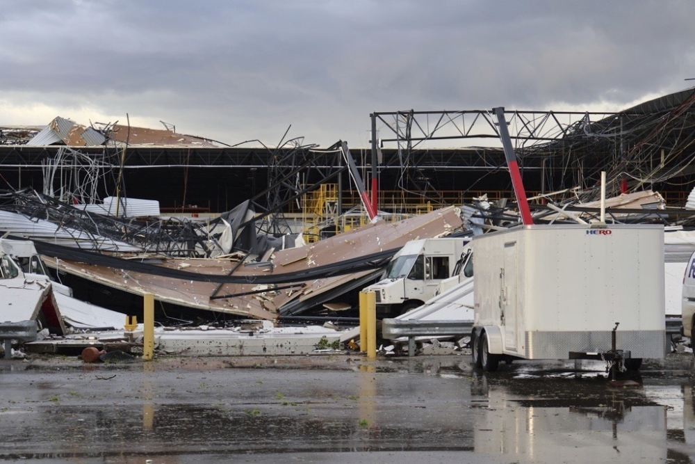
Debris is seen from a damaged FedEx facility after a tornado in Portage, Mich. on Tuesday. Brad Devereaux/Kalamazoo Gazette via AP
About 50 people were trapped inside a FedEx distribution facility after a tornado hit Portage, Mich., on Tuesday evening, Kalamazoo County authorities said.
First responders were trying to get the people out but were waiting for the power company to clear downed wires blocking the way, Taylor Koopman, Kalamazoo County spokeswoman, said Tuesday evening.
FedEx said the company was monitoring the situation.
“Our thoughts are with those affected by the tornado in Portage, Michigan, and we are grateful there were no serious injuries resulting from the damage to our facility at 6701 Portage Road,” company spokeswoman Shannon Davis said. “We continue to assess the damage, and we are implementing contingency plans to lessen any potential impacts on service.”
Part of the roof collapsed after the tornado struck, mlive.com reported. Photos showed walls caved in.
No deaths had been reported in the city as of about 8 p.m., Portage Mayor Patricia Randall said, though crews were still assessing the damage.
The storm caused “extensive” damage in several areas of the city and leaving more than 21,000 of roughly 49,000 residents without power, Randall said in an email. As of about 8 p.m., she had heard of no deaths.
Police were assessing the damage, “but with so many trees and wires down, travel is slow,” Randall said.
A mobile home park in nearby Kalamazoo was also “hit hard,” Koopman said, with “entire homes destroyed.”
On X, Gov. Gretchen Whitmer urged people in southwestern Michigan to “continue monitoring severe weather alerts and follow the advice of emergency officials.”
Several intense tornadoes plowed across parts of southern Michigan on Tuesday evening, causing damage and leaving injuries in their wake. Areas around Kalamazoo and Union City, about 30 miles to the southeast, appeared to be hard hit. More than 30,000 customers were without power across the region following the storms.
Twisters were also confirmed in Indiana and Ohio as storms swarmed the Great Lakes, Midwest and Ohio Valley. Tornado watches stretched from southern Kentucky into southern Michigan on Tuesday evening, where severe storms capable of producing tornadoes, large hail and damaging wind were possible into the night.
In Michigan, one large tornado was seen crossing U.S. Route 131 near Kalamazoo just after 6 p.m. Significant damage was reported just to the south in Portage. A second tornado was also observed near Portage a little more than an hour after the first. The National Weather Service issued “particularly dangerous situation” warnings for both storms, which are reserved for confirmed large and extremely dangerous twisters.
Earlier in the evening, a rare tornado emergency was hoisted by the Weather Service for another storm that tracked through Union City in south-central Michigan and probably produced either a long-track tornado or multiple tornadoes that touched down intermittently for more than an hour.
The tornado emergency in Union City – reserved for the most dire situations when a large tornado threatens a population center – was the first issued in Michigan by the Weather Service.
The tornadoes struck the Midwest, Great Lakes and Ohio Valley just one day after a violent EF4 tornado on the 0-to-5 Enhanced Fujita scale for intensity devastated parts of the city of Barnsdall in northeast Oklahoma, killing one person.
The severe storms that spawned tornadoes erupted as low pressure swept from the southern Plains on Monday into the Great Lakes on Tuesday. A warm front extending east from the low pressure zone served as the main conduit for the tornado-producing thunderstorms in southern Michigan.
At one point there were multiple concurrent “particularly dangerous situation” tornado warnings in addition to the tornado emergency for Union City. More than three dozen tornado warnings had been issued in the Midwest and Great Lakes through 8 p.m. Eastern time.
Large hail was also observed from the rotating thunderstorms that erupted throughout the Midwest. At least 100 reports of large hail were logged by the Weather Service, growing as large as four inches in diameter in Union City and three inches in diameter in Steuben, Ind.
Tuesday marked the 13th day in a row with tornadoes in the Lower 48. As the active storm pattern persists, additional twisters are possible in the Tennessee Valley and Mid-South on Wednesday. Scattered severe storms could hit the Mid-Atlantic and Southeast on Thursday, before a break in severe weather Friday through the weekend.
Comments are not available on this story.
Send questions/comments to the editors.
