

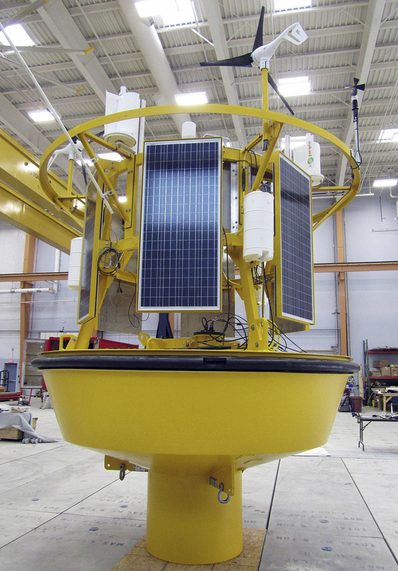
ORONO — A data-collection buoy that can be plopped in the ocean and used to determine the suitability of remote locations for offshore wind farms is ready for real-world testing, the University of Maine announced Friday.
The university’s advanced composites center worked with private industry partners to create a buoy-based system that utilizes a laser system to track wind speeds 400 to 500 feet overhead, the height of offshore wind turbines. The data is relayed to scientists on shore via wireless technology.
Additional Photos
The university said the devices would allow wind power companies to assess potential offshore wind sites for which data is not currently available.
The futuristic-looking buoy will be deployed initially alongside a one-eighth scale offshore wind turbine prototype that will be deployed in about a week off the coast of Castine.
It utilizes a light detection and ranging system, known as LIDAR, which collects wind speed data by sending a laser beam into the sky. Reflected light in the atmosphere is used to determine wind conditions.
“Floating LIDAR technology, once fully validated, will provide us with a cost-effective method to assess the wind resource in areas traditionally off-limits to offshore wind developers,” said Habib Dagher, director of UMaine’s composites center.
The device, formally unveiled on Friday, was created by a partnership that included NRG Systems Inc., AWS Truepower LLC and Leosphere SAS, along with the university’s composites center and its Physical Oceanography Group, which develops and operates real-time ocean observing systems.
Send questions/comments to the editors.

Success. Please wait for the page to reload. If the page does not reload within 5 seconds, please refresh the page.
Enter your email and password to access comments.
Hi, to comment on stories you must . This profile is in addition to your subscription and website login.
Already have a commenting profile? .
Invalid username/password.
Please check your email to confirm and complete your registration.
Only subscribers are eligible to post comments. Please subscribe or login first for digital access. Here’s why.
Use the form below to reset your password. When you've submitted your account email, we will send an email with a reset code.