

Just south of the fishing villages of Jonesport and Beals –the former on the mainland and the latter on Beals Island just across the bridge over Moosabec Reach – is where you’ll find the magnificent Great Wass Island. The largest of the 43 islands in the Great Wass Archipelago, the island is home to a 1,576-acre preserve, owned by The Nature Conservancy, where many miles and hours of adventurous hiking and wildlife watching await.
Great Wass Island projects farther out to sea than any other land mass in Downeast Maine. The waters of the Gulf of Maine mix with the Bay of Fundy here, resulting in a cool and moist climate. Several rare plants and natural communities, well-suited to life in the often extreme conditions of wind, salt spray and an abbreviated growing season, make their home on the island.
Additional Photos
On the exposed headlands are hardy plants like beach-head iris, marsh felwort, blinks and bird’s eye primrose. Inland, the island supports one of the largest stands of the twisted and stunted jack pine in Maine. In the boggy peatlands live the carnivorous pitcher plants and sundews, as well as the baked-apple berry and dragon’s mouth orchid.
Common on the island are bald eagles and ospreys, palm warblers and Lincoln sparrows, boreal chickadees and spruce grouse. Common eiders and great blue herons frequent the shore, where you might also spy harbor seals on the rocks.
The Little Cape Point and Mud Hole trails penetrate the Great Wass Island Preserve, and by combining the two paths plus a connecting walk along the rugged shoreline, hikers can enjoy an outstanding loop trek of 5 miles. The hike is best enjoyed counterclockwise.
The Little Cape Point Trail rises gently to pass through jack pine forests and ancient heaths before trending down to the ocean at Cape Cove. Strings of colorful lobster buoys mark the exit from the woods to the shore at this and similar important trail passages along the route.
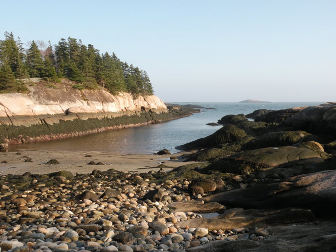
With the promontory of Little Cape Point in view to the northeast, at low tide you can explore among the rocks and driftwood, seaweed and tide pools, and the usual array of man-made detritus washed ashore.
Turning north along the beach, an unnamed trail follows the margin of the ocean for 1.5 miles. It’s a bushwhack of sorts that offers spectacular scenery but variable footing and a smidgen of route-finding challenge. Savor the slow going; this is a special place.
Meander northward over alternating stretches of beach, boulders, cobbles and ledges. Nearing Little Cape Point, climb a rope ladder to the top of a headland, then scamper along the cliffs 75 feet above the water. If time and tides allow, you can explore the spruce- and fir-studded island off the point.
Moose Peak Light on Mistake Island soon comes into focus across Mud Hole Channel. The smaller islands of Water, Knight and Green lie in front of the larger Steele Harbor Island. Farther to the northeast is Head Harbor Island.
Continuing, an incredible series of broad pink granite shelves are interrupted by several coves and crescents of sandy beach and a handful of brief forays into the woods.
After one last long rock slab and a cove of cobbles, the junction with Mud Hole Trail is reached at Sand Cove, where there is a high probability of seeing bald eagles aloft and seals lounging on the rocks of Mink Island.
Finish the walk on the Mud Hole Trail, proceeding west along the narrow passage of Mud Cove, a mudflat at low tide. All too soon the trail merges with Little Cape Point Trail and returns to the trailhead.
Carey Kish of Bowdoin is an avid hiker and freelance outdoors writer. Follow Carey’s adventures in his Maineiac Outdoors blog at: mainetoday.com/blog/maineiac-outdoors.
Copy the Story LinkSend questions/comments to the editors.

Success. Please wait for the page to reload. If the page does not reload within 5 seconds, please refresh the page.
Enter your email and password to access comments.
Hi, to comment on stories you must . This profile is in addition to your subscription and website login.
Already have a commenting profile? .
Invalid username/password.
Please check your email to confirm and complete your registration.
Only subscribers are eligible to post comments. Please subscribe or login first for digital access. Here’s why.
Use the form below to reset your password. When you've submitted your account email, we will send an email with a reset code.