


More than 50 people crowded into the Portland City Council chambers Monday for a council workshop on a developer’s request for a zone change that would allow the redevelopment of the historic Portland Co. complex on the eastern waterfront.
The turnout of opponents wearing large bright red stickers saying “No Blank Check, Support Responsible Development” was notable because no public comment was allowed at the meeting. Instead, it was a chance for councilors to get additional information before they vote April 6.
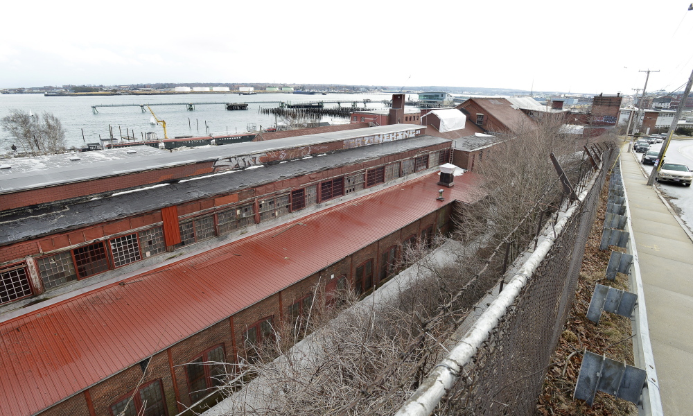
Rezoning 58 Fore St. is only one step in a long approval process. The project must also go before the city’s Historic Preservation Board and site plans still need to be drafted and reviewed by the Planning Board.
During the two-hour meeting, councilors noted the public feedback received about the redevelopment proposal.
“It’s a fairly substantial opportunity for the city of Portland and obviously it’s worrisome to some people,” said City Councilor Jon Hinck.
Rezoning the property would allow for taller buildings – in some cases as tall as 65 feet – and a wider range of uses on the site, including residential, restaurant and retail. Portions of the property sit nearly 90 feet below Fore Street, which climbs Munjoy Hill.
Some residents of the area worry that their views of Casco Bay could be blocked if the site is redeveloped, and there is concern about whether building heights should be measured from the flood plain or by averaging the grade of the land. It’s a key distinction that would determine whether the upper portion of Fore Street could be developed, obstructing water views of current residents. It could become central to any lawsuits that may challenge any future project approvals.
Confusion about how to measure building heights dates back to 2004. Though extensive discussion centered on measuring building heights from the flood plain to limit building heights, the council ultimately approved a policy that measures building heights at the average grade of a site, said William Needleman, the city’s waterfront coordinator.
A development team led by local developers James Brady and Casey Prentice is seeking the zoning recommended in the city’s 2004 Eastern Waterfront Master Plan, but nearby residents are concerned about a lack of details in the development plan, which they say would restrict sweeping views of Casco Bay
Tentative uses at the site include a Faneuil Hall-like market, restaurants, spaces for artists and tradesmen to make and sell their wares, an expanded marina, a hotel and residences.
“It was always envisioned to be developed into a mixed-use site,” said Jeff Levine, the city’s planning and urban development director.
Though other nearby parcels already have been rezoned in accordance with the 2004 plan, the former owner of the Portland Co. didn’t change the zoning because he didn’t have a redevelopment plan to pursue, said Levine.
The developers, who bought the property for $14.1 million in 2013 and 2014, have agreed to limit building heights along Fore Street to 35 feet, which is lower than some existing houses in the area. But area residents believe that is still too tall.
No public comment was taken at the workshop, but area residents calling themselves the Soul of Portland sent out a press release Monday morning, calling on councilors to “protect the historic seaside treasure of the Fore Street vista and Promenade trail.”
“We call on the Council to ensure that development on the eastern waterfront preserves public vistas and access to its treasures,” said Soul of Portland spokeswoman Anne Rand, a former state senator. “There is no other public place in the city to watch a Casco Bay Lines ferry leave its berth and travel out of the harbor on its journey down the bay. Access to this view is just as important to the quality of life in Portland as are the vistas from the Western and Eastern Promenades. People come from all over the U.S. and world to experience our seaside city.”
Nini Mc Manamy, a Soul of Portland organizer, said the group plans to submit a petition with roughly 800 signatures collected online and in person at next week’s council meeting in support of protecting public access to and the views through the site, including the harbor panorama. They also want to protect the residential character of adjacent neighborhoods and not diminish the Eastern Prom Trail.
Kara Wooldrik, the executive director of Portland Trails, said in an interview Monday afternoon that fears about permanently losing the Eastern Prom Trail are unfounded. The trail and the narrow-gauge railroad lines are controlled through an easement held by the Maine Department of Transportation.
Wooldrik said the organization, a nonprofit land trust that manages miles of trails in Portland, met with the developers months ago and is confident they wanted to work to move the trail closer to the water.
“We’re proud the trail is part of its future no matter what,” Wooldrik said.
Brady, the developer, expressed satisfaction with the workshop.
“We were pleased with how the Portland City staff articulated the extensive work that went into establishing the community vision 10 years ago that is now part of the City’s comprehensive plan,” he said in an email. “Responses to questions from the Council ought to allay fears expressed by concerned neighbors.”
Copy the Story Link
Send questions/comments to the editors.

Success. Please wait for the page to reload. If the page does not reload within 5 seconds, please refresh the page.
Enter your email and password to access comments.
Hi, to comment on stories you must . This profile is in addition to your subscription and website login.
Already have a commenting profile? .
Invalid username/password.
Please check your email to confirm and complete your registration.
Only subscribers are eligible to post comments. Please subscribe or login first for digital access. Here’s why.
Use the form below to reset your password. When you've submitted your account email, we will send an email with a reset code.