


While folks in Iowa are hoping to beat a blizzard before their caucuses, here in Maine our snow is rapidly vanishing or already gone. Winter just can’t seem to gain a foothold this year and the reality is it may never do so here in New England.
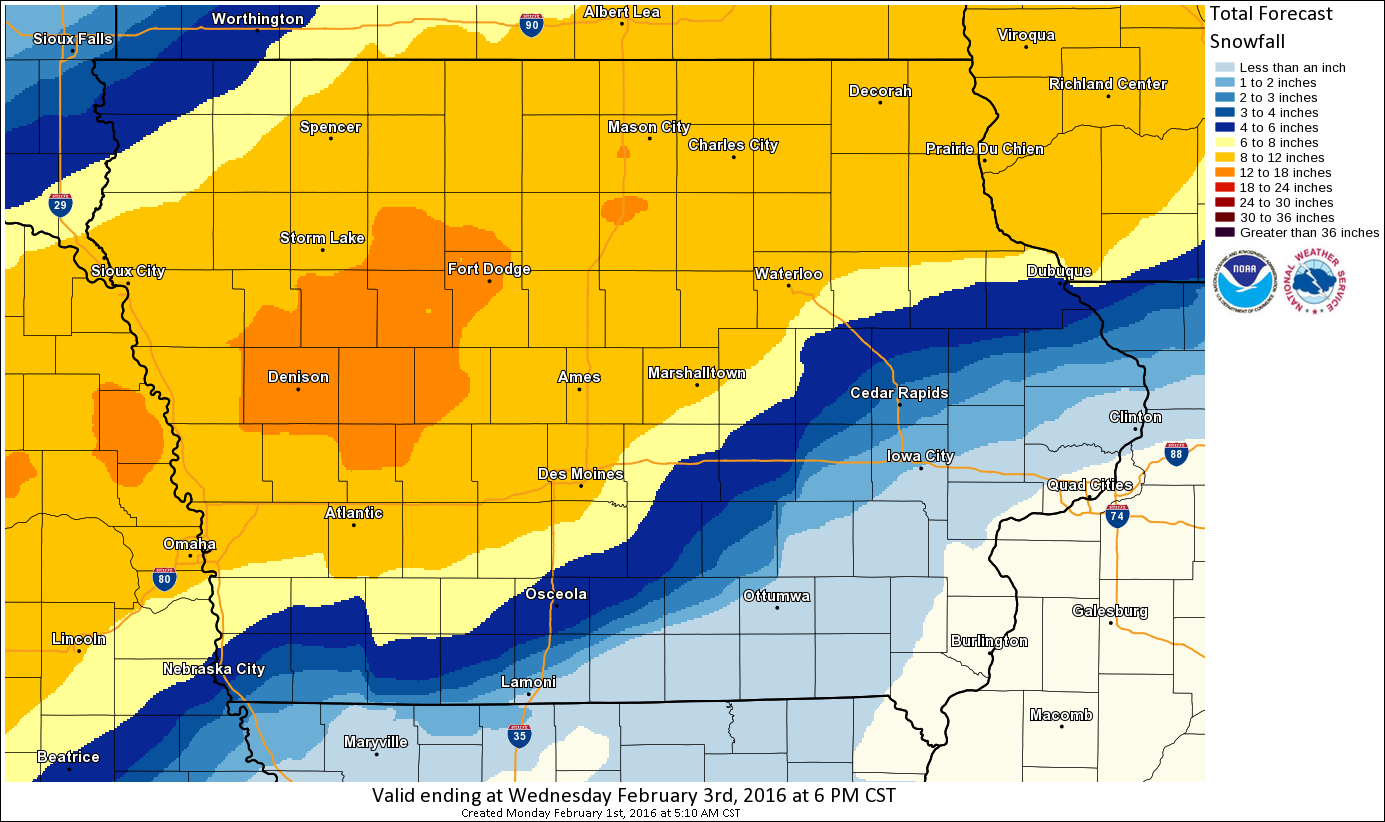
Predicted snow in Iowa early this week
Very warm start to February
With temperatures into the 50s this afternoon, along with some sunshine, the feeling of spring (including the occasional flying insect) will abound. The record for today is 63 degrees and that was set back in 1989. We won’t come close to it, but with temperatures as warm as they are, you can safely say this is one of the warmest starts to February on record. We only have to reach 50 for today to rank among the top 5 warmest starts to February.
Meteorological winter is now two-thirds over. Since beginning back on Dec. 1, much of New England has seen little in the way of cold and snow. For those forecasters who predicted a cold and snowy winter it’s becoming less and less likely this will be the case.
One can certainly point to last year and other years when snow and cold began late in winter and continued through March, and while I still expect the second half of this month to be colder than the first, the entire first half of the winter of 2015-2016 will likely be remembered for the lack of snow and cold.
Many forecasters in New England have a deep love of the cold and snow so there’s an unconscious tendency to hunt for it on the models. If you listen carefully to forecasters over the next week, you’ll hear many of them focusing on the possible snow and cold beginning this weekend or during next week.
At this point I’m looking at reasons why the pattern will continue, not why it’s going to break. I’d rather go with the grain of this winter’s trends than look for reasons to go against it.
After all, with this warmth, it’s easy to forget what is typical. On average we’d see about 18 to 38 additional inches of snow across much of southern Maine from today through the springtime. If Portland received that average amount of snowfall during the rest of the winter, which I think is unlikely, we’d still end up with a winter at least somewhat below normal in snowfall. Of course two big storms can change the trend.
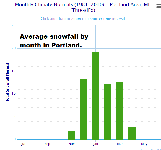
Average snowfall in Portland, ME 1981-2010
Temperatures are running so much warmer than average for Dec. 1 through Jan. 31 that I am confident in saying this year, meteorological winter will end up warmer than average. Yes, it’s going to turn colder later this month and the cold could last a week or more, but that’s not a big deal in the big picture.
The bottom line is we still have at least two arctic outbreaks on the horizon and I still expect several chances of snowstorms – maybe even a big one. February and March are both snowy months in southern Maine. I expect we will at least double the snow we’ve already seen.
Here’s the reality of this winter: two of the four coldest and snowiest months are now behind us and we got off very easy. This month we gain an hour and a quarter of daylight and a full 5 degrees on average temperatures. Only 29 days into the future will we really know what happened.
Please follow me on Twitter @growingwisdom for more weather updates.
Copy the Story LinkSend questions/comments to the editors.

Success. Please wait for the page to reload. If the page does not reload within 5 seconds, please refresh the page.
Enter your email and password to access comments.
Hi, to comment on stories you must . This profile is in addition to your subscription and website login.
Already have a commenting profile? .
Invalid username/password.
Please check your email to confirm and complete your registration.
Only subscribers are eligible to post comments. Please subscribe or login first for digital access. Here’s why.
Use the form below to reset your password. When you've submitted your account email, we will send an email with a reset code.