

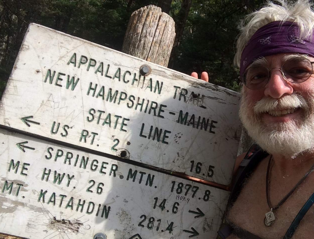
At noon on my second day after hiking out of Gorham, New Hampshire, I reached the Maine border. The weathered sign spelled out the mileage I knew all too well: 1,900 miles south to Springer Mountain, Georgia, and 281 miles north to Katahdin. Thirteen states were behind me; only my home state of Maine remained.
The moment was one I’d long waited for, and certainly cause for celebration. But all alone in this remote notch thick with spruce and fir in the Mahoosuc Range, my mind was focused on the month of rugged going still ahead of me. I took a selfie with a big smile and moved on.
The three peaks of Mt. Goose Eye and then Fulling Mill Mountain were a good warmup for Mahoosuc Notch, reputed to be the hardest mile of the entire Appalachian Trail. Sure, it’s a grunt of a boulder scramble, but I always found it more fun than difficult.
I started through the notch with just two hours of daylight left, leaving little margin for error. An hour and a quarter, several bloodied knuckles, and a few tears to pack and clothing later, I was humbly pitching camp on the far side in the shadow of Mahoosuc Arm. The notch was tougher than I remembered and it was good to have it done.
The incredible September weather continued as I clambered over the scenic heights of Old Speck and the Baldpates under perfect blue skies. But then the heat and humidity spiked, and slowed my pace to a sweaty crawl. When I checked into the hiker hostel in Andover I learned the temperature was a balmy 92 degrees. Yikes.
I hadn’t planned on staying three nights in Andover, but given the comfy environs, a great group of thru-hikers in residence and a hiker with a car who offered to slackpack us if we so desired, I couldn’t resist. So I ditched my full backpack and shouldered a light pack for a couple days, tackling Wyman, Hall and Moody mountains, then Old Blue and the Bemis Range.
Walking through the mountains of western Maine was a true joy and I fairly skipped along the trail. No maps or guidebooks were needed for this homey hiker; I knew every mile of the AT from here to the finish by heart.
The end of this six-month adventure was in sight, and I had mixed feelings. I was ready to be done, ready to go home and get on with life, but I wasn’t sure how this new normal of trail life I’d known since Georgia would affect my re-entry into the so-called real world. Besides, I was still having fun. I guess time would tell.
I’d experienced plenty of wonderful trail magic along the AT but here in Maine it was extra special, courtesy of both friends and strangers. There was cold beer and pizza in Rangeley, a new backpacker stove (mine had quit) hidden at the trailhead parking lot on Route 27, fine dining with white table cloths in Stratton, a cozy night in a cabin near Caratunk, a bucket of beer, a meal and a bed at Moxie Pond, sweet goodies and cold drinks at Long Falls Dam Road, and much more. I can’t say thank you enough to the kind, trail-loving folks of the Pine Tree State.
Missing hiker Gerry Largay was in my thoughts as I traversed the peaks of Saddleback, then Spaulding and the Crockers. Across the beautiful Bigelows I happily marched, followed by the Carry Ponds. Beyond the Kennebec River canoe ferry crossing, I chugged over Pleasant Pond and Moxie Bald mountains into Monson, the last trail town. Here I was greeted by my lovely wife and “Welcome Beerman” on the marquis outside the Lakeshore House.
With 2,074 miles completed, only the 100-Mile Wilderness and 15 miles through Baxter State Park to Katahdin’s summit lay ahead. I was running out of white blazes.
Carey Kish of Mount Desert Island is editor of AMC’s Maine Mountain Guide. Follow Carey’s AT thru-hike in his Maineiac Outdoors blog at:
mainetoday.com/blog/ maineiac-outdoors
Copy the Story LinkSend questions/comments to the editors.

Success. Please wait for the page to reload. If the page does not reload within 5 seconds, please refresh the page.
Enter your email and password to access comments.
Hi, to comment on stories you must . This profile is in addition to your subscription and website login.
Already have a commenting profile? .
Invalid username/password.
Please check your email to confirm and complete your registration.
Only subscribers are eligible to post comments. Please subscribe or login first for digital access. Here’s why.
Use the form below to reset your password. When you've submitted your account email, we will send an email with a reset code.