


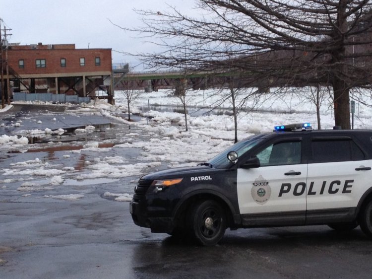
AUGUSTA — The Front Street parking lot along the Kennebec River flooded Wednesday as river ice jammed and sent water over its banks.
At least one motorist had to wade through floodwater and chunks of ice to move a vehicle away from the rising river.
An ice jam, high tide and an unseasonable amount of runoff combined to cause the localized flooding, authorities said.
“It was just the culmination of everything. The ice was flowing down the channel up to an hour ago,” said Augusta police Lt. Kevin Lully Wednesday morning. Then, Lully said, ice began backing up as the tide rose, and around 9:30 a.m. ice chunks and river water overflowed into the northern end of the Front Street parking lot.
All vehicles were removed safely. One motorist arrived just as police were getting out some rope to try to pull her vehicle out of harm’s way, Lully said. The woman walked through shin-high water to get to her vehicle and drive it out of the parking lot.
Sean Goodwin, Kennebec County Emergency Management director, said the river rose 3 or 4 feet in just a half-hour. He said such a rapid rise is a sure indication the flood was primarily caused by the ice jam.
“When it jumps 3 or 4 feet, that’s an ice jam,” Goodwin said.
He said the agency will continue to monitor the jam, which, if it doesn’t break up, could cause long-term problems.
He said the ice below the site, from just below the jam to the Richmond-Dresden bridge, is intact and fairly smooth, which trapped the broken ice upstream in Augusta.
“You’d hope the tide would come up and break up the ice jam, but there’s no place for the jam to go,” Goodwin said. “We’re not sure when it will flush out, because there is nowhere for it to flush to.”
The city’s Public Works Department sent out an emergency notification to warn people whose vehicles were parked in the lot to remove them. Lully said authorities were fortunate to be able to notify all the people whose vehicles were in harm’s way..
High tide on the Kennebec in Augusta occurred about 10:25 a.m. The river reached more than 14 feet at 11:24 a.m., as measured by a U.S. Geological Survey site at Calumet Bridge. Flood stage is 12 feet.
The river crested there at 34 feet in April 1987. A mile-long ice jam in January 2010 sent floodwaters into parts of downtown Augusta and Hallowell when the river topped 17 feet.
Downriver flood-prone areas of Hallowell appeared to be unaffected and dry Wednesday morning with the ice there flat and not broken up.
The jam appeared to be only between just below Calumet Bridge at Old Fort Western to just below Memorial Bridge in Augusta.
The National Weather Service issued a flood warning in effect until 1:30 a.m. Thursday.
Mobile users click here to watch video.
Send questions/comments to the editors.

Success. Please wait for the page to reload. If the page does not reload within 5 seconds, please refresh the page.
Enter your email and password to access comments.
Hi, to comment on stories you must . This profile is in addition to your subscription and website login.
Already have a commenting profile? .
Invalid username/password.
Please check your email to confirm and complete your registration.
Only subscribers are eligible to post comments. Please subscribe or login first for digital access. Here’s why.
Use the form below to reset your password. When you've submitted your account email, we will send an email with a reset code.