

Another snowstorm is on the way! This one comes as a two-part storm.
The first round of snow starts up late Sunday and lasts through Monday. This will be localized to western Maine.
The second round starts up Monday night and lasts into Wednesday morning. All of Maine will get in on the wintry weather with this part of the storm. I broke it down below based on the timing of the two parts.
Part one: Sunday night into Monday evening … totals, timing, impacts
The first part of this storm starts up late Sunday. It’ll be cold so mixing is not a concern. In other words, expect pure snow as things get going through western Maine. The image below shows the timing of snow for Monday.

Snow spreads from western Maine into eastern Maine through the day. NEWS CENTER Maine
There will likely be some impacts to the morning commute through parts of York and Cumberland counties.
The snow takes its time moving into the rest of Maine, so Augusta likely will not see flakes until Monday afternoon. Eastern Maine and northern Maine stay partly to mostly cloudy during the day Monday.
Totals for the first part of this storm will not be all that impressive, but it will be enough to cause some travel issues.
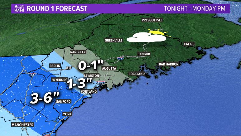
These totals go through 5 p.m. Monday. NEWS CENTER Maine
This map only includes the first piece of this storm. It is from late Sunday night through about 5 p.m. Monday. In other words, there could be some commute impacts in the morning, and they will be a little more widespread by Monday evening.
Part two: Monday evening through Wednesday morning … timing, totals, precip type, and impacts
The snow becomes steadier and more widespread as a coastal low forms off the coast of Maine.

The coastal storm brings steadier snow to Maine. NEWS CENTER Maine
As this low develops, it does two things…
- The warmer air causes some rain and ice to mix in along the coastline.
- Colder air inland allows pure snow, and snow falls through the entire state.
This is going to cause slick conditions for all of the commutes on Tuesday. It’s important to note that Tuesday is New Year’s Eve.
Snow totals will be much more impressive with this second burst of snow. There is a large part of Maine that receives 6-10 inches. Even along the coast, where rain and ice cut back totals a bit, there will still likely be some issues traveling.
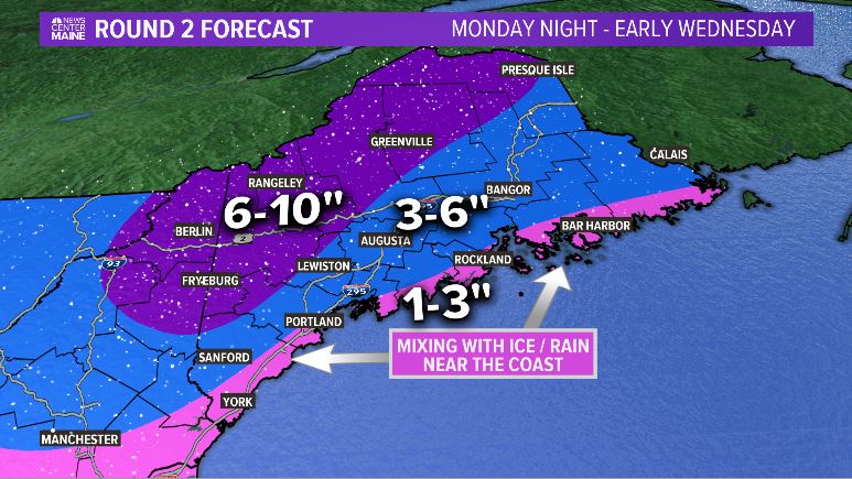
These are the forecast snow totals for the second part of the storm. NEWS CENTER Maine
Watch for reduced visibility under any snow bands that develop.
Snow showers clear up on Wednesday morning. Most Mainers ring in 2020 with a fresh coating of snow on the ground. There’s a chance it all gets washed away as more warm air and rain are in the forecast for Friday.
Stay safe and have a great holiday. If you want more updates, follow me on Twitter and Facebook. I’ll be posting during the event to keep everyone informed.
Copy the Story Link
Send questions/comments to the editors.

Success. Please wait for the page to reload. If the page does not reload within 5 seconds, please refresh the page.
Enter your email and password to access comments.
Hi, to comment on stories you must . This profile is in addition to your subscription and website login.
Already have a commenting profile? .
Invalid username/password.
Please check your email to confirm and complete your registration.
Only subscribers are eligible to post comments. Please subscribe or login first for digital access. Here’s why.
Use the form below to reset your password. When you've submitted your account email, we will send an email with a reset code.