

Paddlers maneuver around an obstacle on Ross Stream. Contributed
Remote, infrequently paddled, Ross Stream is a tributary of the Allagash River that enters the iconic waterway from the west at Long Lake. Chemquasabamticook is its Native American name. Given the difficulty I have spelling and pronouncing it, I’m begging the pardon of my Wabanaki ancestors and using Ross in this narrative.
Paddling Ross has been on my bucket list for many years. Since there is no U.S. Geological Survey gauge on the stream, determining when there is adequate water for a trip is problematic. My source of information for the Allagash watershed is venerable outfitter Norm L’Italien, owner of Pelletier Camps in St. Francis. During our winter conversations, he predicted mid-May would likely be a good start time. A trip beginning May 16 was planned. When our group arrived at Pelletier Camps the evening before, Norm reported his inspection of Ross earlier in the day indicated it was at a good level to paddle. The trip was on.
When you’re old, getting invited on exciting river trips is a concern. The antidote is to organize them yourself. I assembled a team of seven experienced paddlers that included my son, Adam, and a combination of seniors and youngsters. I easily qualified as the group’s ancient mariner. We consisted of two tandem canoes, two solo canoes, and I paddled an expedition kayak, a concession to old age.
Earl, one of Norm’s experienced shuttle drivers, transported us by van and trailer through a confusing labyrinth of logging roads to a bridge over Ross Stream on Poulin Road just a short distance downstream from the outlet of Ross Lake. We were thrilled to find sufficient water to meet our needs. The addition of sunshine and light winds provided the perfect beginning for our journey.
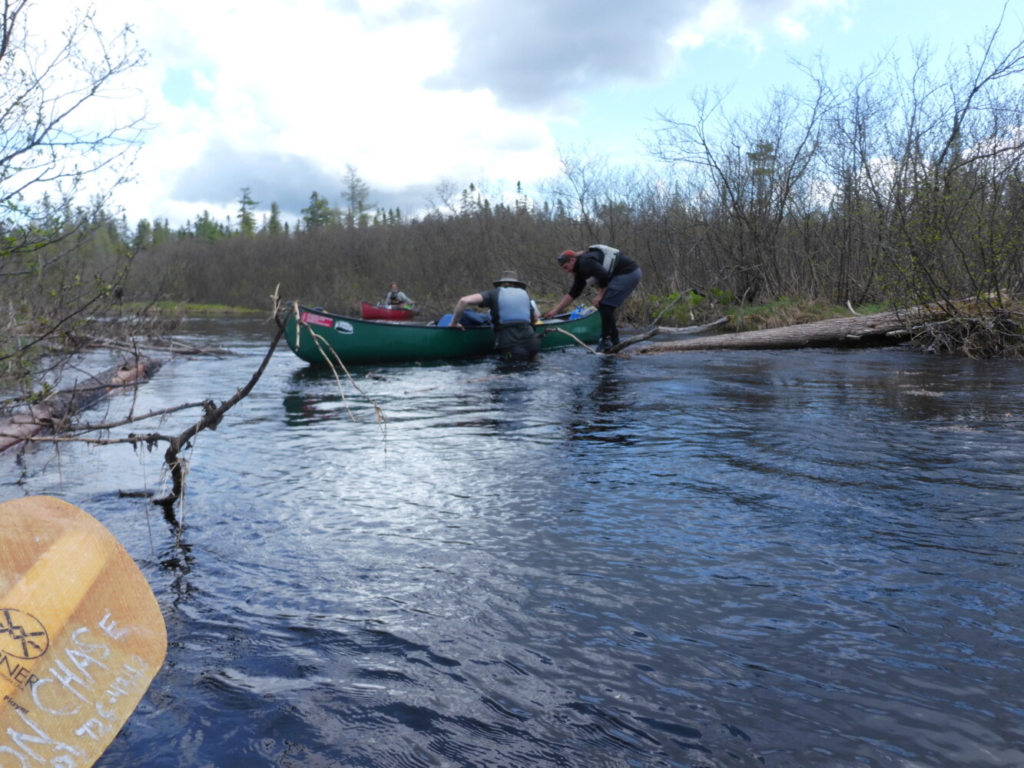
From the outset, the narrow twisting stream was a delight to paddle. Initially, we navigated through a series of easy rapids to a section of slack water where the stream was jammed with debris in three locations. Our resolute band was able to forge through or around each impediment without the need to portage. Several miles of exhilarating rapids followed.
Once entering calm water a few miles upstream of Clayton Lake, we started hunting for a reputed campsite near Kelly Brook, our intended destination for the night. Despite a determined effort, it was never located. Our progress was complicated by two confusing channels that didn’t appear on our maps. Substantial exploration resulted. A benefit of our wanderings was sighting a cow moose and her calf, the first of several moose encounters during the voyage.
A tandem canoe team navigates one of the many rapids on Ross Stream. Contributed
After reaching scenic Clayton Lake, we fought a strong headwind during our traverse to the outlet. Reentering Ross Stream, our search for an adequate campsite continued. A location that could accommodate six tents was finally discovered in a sparsely wooded area on river left. Since the forecast called for heavy rain, an extensive tarp city was erected. The decision was a good one as rain soon began and continued through the night.
The precipitation ended during breakfast the following morning and skies gradually cleared. While launching from our improvised tent site, a large moose crossed the river just above us. Miles of entertaining whitewater followed to a dead water where the stream turned abruptly east. After a brief paddle, we joined Long Lake in the Allagash Waterway. My book, “Maine Al Fresco: The Fifty Finest Outdoor Adventures in Maine,” relates the details of an expedition down Musquacook Stream, another significant tributary on the east side of the Allagash.
The rarest of all winds, a tailwind, helped propel us north to a superb campsite next to the remains of washed-out Long Lake Dam. A steady gale provided an excellent opportunity to dry gear dampened by rain during the previous night. Two groups passed while we were establishing camp. One lined the whitewater descent where the dam once existed while the other plummeted through the sizeable waves. Watching the excitement stimulated several in our group to spend time playing in the rapid created by the pitch. Despite a herculean effort, no one was able to surf the substantial wave at the top.
Forty-five miles remained on the Allagash Waterway. The water level was high and many more adventures were anticipated. Picturesque Round Pond was our goal for day three where we hoped to climb Round Pond Mountain if weather conditions permitted.
Ron Chase resides in Topsham. His latest book, “Maine Al Fresco: The Fifty Finest Outdoor Adventures in Maine” is available at https://www.northcountrypress.com/maine-al-fresco.html or in bookstores and through online distributors. His previous books are “The Great Mars Hill Bank Robbery” and “Mountains for Mortals – New England.” Visit his website at www.ronchaseoutdoors.com or he can be reached at ronchaseoutdooors@comcast.net.
Canoeists dodge a ledge on Ross Stream. Contributed
Comments are not available on this story.
Send questions/comments to the editors.


