

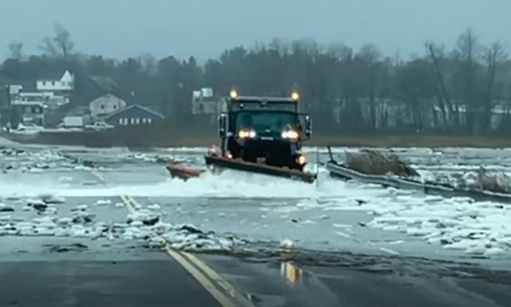
Flooding takes place over Route 1 at the Scarborough Marsh during a January 2022 storm event. Courtesy photo
The Town of Scarborough is partnering with the Maine Department of Transportation (Maine DOT) on a resiliency project associated with the marsh crossings at Route 1 and Route 9 (Pine Point Road). There will be a public meeting on the topic on Thursday, Nov. 9 from 6 to 8 p.m. in the Council Chambers of Scarborough Town Hall. A Zoom link will be made available for remote participation on the Town of Scarborough website, and the meeting will also be broadcast live on the Town’s YouTube channel.
In April 2022, Scarborough was one of 75 communities to receive a Community Action Grant to fight and adapt to climate change. The two-year State of Maine grant is funded through the Governor’s Office of Planning, Innovation, and the Future to assist municipalities and tribal entities in implementing elements of the state’s climate action plan, Maine Won’t Wait. Scarborough received $46,240 for its proposed project, “Climate-Ready Infrastructure: Building a Resilient Route 1 and Pine Point Road.” The funding will be used to develop resiliency strategies for Route 1 where it crosses the Scarborough Marsh and Route 9 near the Maine Audubon Center.
“Past studies identified these sections of roads as two of the most vulnerable in Scarborough,” said Jami Fitch, Scarborough Sustainability manager. US Route 1 is a major mobility corridor that stretches through the heart of Scarborough. Approximately 30,000 vehicles travel the road on a daily basis. It serves as a critical evacuation route, economic corridor, and connection between the greater Portland and Saco areas.
Pine Point Road is a less traveled road but is similarly critical to those who live, work, and play in Pine Point. This roadway is a primary access point to Scarborough’s largest beach community and also serves as the primary evacuation route for approximately 900 properties in Scarborough’s Pine Point neighborhood.
Both roads are regularly inundated by sea water during astronomical high tides and/or storm events, and the need to address its infrastructure has been identified on both astate and local level. Maine DOT listed these areas as two of the top priority resiliency projects in the state due to their vulnerability to sea level rise. Past studies, including those carried out by the Sea Level Adaptation Working Group (SLAWG) and private consultants, have also identified these roads among Scarborough’s most vulnerable. Scarborough’s Comprehensive Plan identifies resiliency planning for the town’s critical infrastructure as a significant priority for the town. In a 2022 community meeting on climate change and resiliency, 89% of participants at the indicated that they were “very concerned” about resiliency on Scarborough’s infrastructure.
The Scarborough Marsh is Maine’s largest salt marsh and is an essential habitat for many threatened and endangered species. The marsh is also impacted by sea level rise and development pressures within its watershed. Any alteration to the US Route 1 and Pine Point Road will need to consider potential impacts to the marsh.
The resiliency strategies being developed for this area aim to meet the needs of both the public and the environment, requiring extensive public input. The town has begun initiating stakeholder engagement for this project, starting with a meeting of the federal and state environmental agencies. The group discussed the overall significance of these roadway corridors related to emergency access, public safety, general mobility, and need for safe passage of pedestrians and bicyclists. These desires are being considered as we work to minimize the environmental impacts to the town’s and region’s greatest natural resource. Please join the public meeting on Nov. 9 at 6 p.m. to continue the conversation.
Comments are not available on this story.
Send questions/comments to the editors.
