

A powerful storm front is sweeping across the northern United States, inciting rapid swings in temperature and fast-moving fires in the Plains. It’s also generating wind-swept snows from the Mountain West to northern Minnesota and the potential for tornadic thunderstorms in the Midwest.
An outbreak of infernos has already torched more than 240,000 acres in the Texas Panhandle. Mandatory evacuation orders were issued for parts of the area by the Texas Emergency Management Agerncy while “fire warnings” were issued by the National Weather Service, an urgent call to action urging residents to “be prepared to evacuate quickly.”
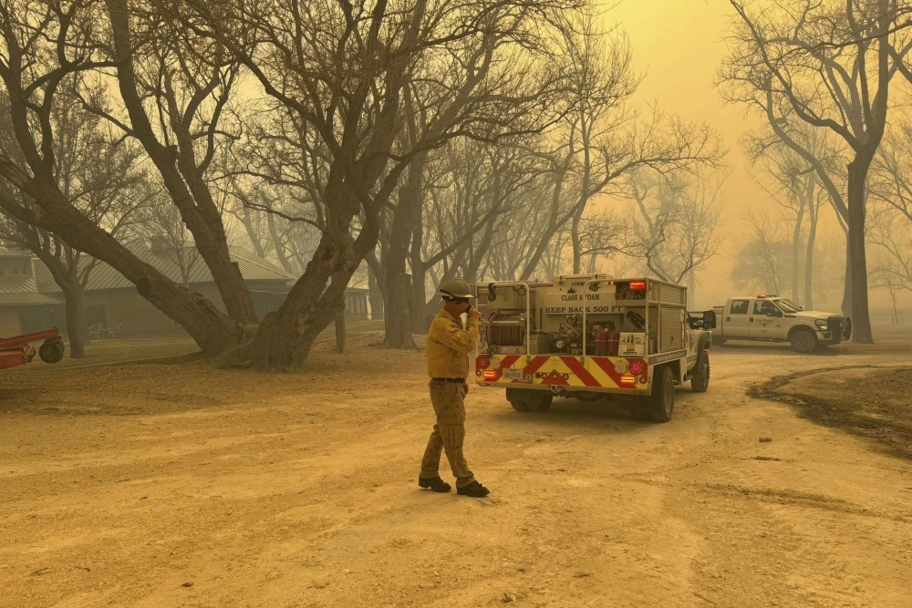
Flower Mound firefighters respond to a fire in the Texas Panhandle on Tuesday. A rapidly widening Texas wildfire doubled in size Tuesday and prompted evacuation orders in at least one small town. Flower Mound Fire Department via AP
“Smoke and fire will present a threat to life and property,” warned the Weather Service office in Amarillo, Tex.
One of the blazes – the Smokehouse Creek Fire in Hutchinson County, Tex. – had burned more than 200,000 acres and was at zero containment. The fire was a threat to the towns of Canadian and Glazier Tuesday afternoon, where residents were asked to evacuate. It had grown into the state’s sixth-largest fire on record according to Fox Weather.
Another blaze, the Grape Vine Fire southeast of Pampa, swelled to 30,000 acres in size with 15% containment.
Satellites captured distressing imagery of a grass fire rapidly spreading near North Platte, Neb., quickly charring fields and leaving a burn scar in its wake.
The same storm front will bring severe thunderstorms to the Midwest on Tuesday, including with the risk of tornadoes. That risk will be maximized along a warm front from Chicago to Detroit, but residents as far south as extreme northwest Tennessee will face at least some threat of severe thunderstorms. The Weather Service issued a tornado watch for Chicago and the surrounding area until 10 p.m. local time.
On the system’s cold side, heavy snow has been plastering the Intermountain West, with reports of up to 21 inches in the Cascades. Those snows will continue to spread east, dumping a foot or more on the central and northern Rockies and a plowable accumulation all the way east into northern Minnesota.
In Fargo, N.D., where temperatures soared above 60 degrees Monday, temperatures had plummeted to 7 degrees by midday Tuesday, with heavy snow and 50 mph gusts. The city is under a blizzard warning until 6 p.m. local time.
Signs point to a similarly dynamic storm system, with an attendant severe thunderstorm risk once again, trekking across the Lower 48 states early next week.
DANGEROUS FIRES ERUPT
For a second straight day, the Weather Service’s Storm Prediction Center has declared a “critical” risk of wildfires in the Texas Panhandle and western Oklahoma for Tuesday, while an “elevated” risk exists from Texas’s Permian Basin north to Missouri. A similar area is blanketed by red flag warnings, within which the Weather Service warns that “a combination of strong winds, low relative humidity, and dry fuels can contribute to extreme fire behavior.”
That certainly was the case Monday, when wildfires grew exponentially in size. While no property damage or casualties were immediately reported, residents in the town of Canadian, Tex., were urged to be on standby in case an evacuation order was eventually issued. The rapidly-advancing fire front, which was surging east at a pace of 3 to 5 mph overnight, was visible from weather satellites.
Tuesday’s weather was slated to be a classic recipe for fire weather – a trifecta of problematic conditions.
Temperatures on Monday were extreme by February standards, with similarly anomalous heat expected for Tuesday. A record high of 93 degrees was logged in Dallas, a far cry from the late-winter average of 63 degrees. Killeen, Tex., hit 100 degrees Monday, the first station in the contiguous United States to do so so far this season.
Highs 25 to 35 degrees above average will continue to sap moisture from the ground Tuesday, since hotter temperatures are more efficient at evaporating humidity from vegetation. That will leave fuels ripe to burn.
On top of the heat, westerly winds are gusting to 60 mph in the Texas Panhandle, fanning the flames of any active fires. High wind warnings cover eastern New Mexico, southeast Colorado and the Texas and Oklahoma Panhandles.
Winds gusted to 63 mph in Amarillo, Tex., on Monday, 55 mph in Childress, Tex., and 61 mph in Tucumcari, N.M.
The westerly winds also induce something called downsloping, in which air from higher elevations in the Rockies is dragged to lower elevations (the Plains). As it descends in altitude, it is compressed, heats up and dries out, increasing the fire danger.
Fire behavior could become erratic Tuesday evening as the swift, dramatic cold front sweeps in from the north-northwest, suddenly switching winds out of the north. While that will bring cooler temperatures and higher humidity, which ordinarily aid firefighting efforts, it will potentially encourage a different direction of fire spread.
Once winds settle in the front’s wake, the fire risk should gradually ease over the coming days.
SEVERE THUNDERSTORMS AND TORNADOES
As the storm front enters the Midwest, strong to severe storms are forecast to erupt Tuesday afternoon and evening.
A broad Level 2 out of 5 risk of severe weather was drawn by the Storm Prediction Center for much of the Midwest from Michigan to south of St. Louis. Within that zone, there are two smaller Level 3 out of 5 “enhanced risk” areas that include areas just northwest of Chicago and the region surrounding Kentucky’s northern border.
A low-pressure system over the Great Lakes is drawing north a tongue of warm air and high humidity, which will provide ample fuel for storms. However, a strong “cap,” or layer of warm air about a mile above the ground, will suppress storm activity until the pent-up instability breaks the cap during the late afternoon or evening. Once that occurs, explosive thunderstorm development is probable. Some storms could produce hail to golf ball or even softball size.
Strong jet stream winds will also allow thunderstorms to mix momentum to the surface in the form of strong to locally damaging wind gusts, especially if thunderstorms organize into squall lines.
The tornado risk is a bit more tricky to pin down. While there is a swift change of wind speed with height, winds don’t change direction much – they’re mostly out of the south or southwest. That means there won’t be much turning of the wind.
That said, two areas will need to be closely watched for potential tornado development:
• Along the warm front. Warm fronts, like the one that will stretch from near Chicago to southern Michigan, usually are rich in low-level helicity, or spin. That might encourage thunderstorms near the boundary to rotate.
• Ahead of the dryline bulge. The “dryline” is the leading edge of dry air dragged east by the low pressure system. Easterly winds curving along that dryline bulge will contact against southwesterly winds aloft, bolstering low-level spin. That will mostly occur south of Chicago.
WINTER WEATHER
The low-pressure system is dragging the cold front east, allowing frigid Canadian air to spill south over the Rockies and northern Plains. A batch of snow was pushing east out of the Columbia River Basin into Montana, with additional snow showers farther south all the way to the Four Corners. Snow totals have topped 20 inches in the Cascades, 18 inches in Montana and a foot in Idaho and Utah.
A few winter storm warnings and winter weather advisories are still up in the highest terrain of the Rockies, where the snowfall could overlap with strong winds to result in starkly-reduced visibilities. A few snow squall warnings were also hoisted in eastern Colorado for quick bursts of snow that mimic the hit-or-miss nature of summertime thunderstorms.
The worst winter weather may actually strike the North Dakota-Minnesota border region, where blizzard warnings are in effect, as well as northern Minnesota. A fine, powdery snow was falling throughout this region on Tuesday, because of temperatures in the single digits. That made the snow lighter and easier to whip about in winds gusting over 50 mph.
“Widespread blowing snow is causing sharply reduced visibility,” warned the Weather Service. “The hazardous conditions will impact travel.”
Comments are not available on this story.
Send questions/comments to the editors.
