

Big Moose Mountain in Big Moose Township a few miles west of Greenville is best known for the ski trails of the now defunct Big Squaw Mountain Resort on its north slope, and the popular hiking trail on its south slope that leads to the old fire tower atop the 3,150-foot summit. There’s another spot on the mountain, however, that’s also worth exploring.
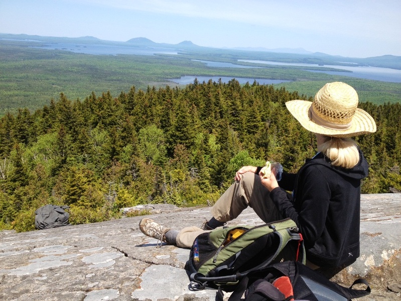
From the Big Moose summit, the long and undulating – and trailless – northwest ridgeline culminates at the lesser known and little-visited pinnacle of Eagle Rock, a stunning bald outcropping that offers panoramic views equal to or perhaps even better than those from atop Big Moose.
Additional Photos
Hikers can reach this airy perch by way of a mostly moderate trek over a 1.5-mile trail that leaves from a gravel road just east of Indian Pond. The trail is not maintained but is easy enough to follow, although you will have to weave around several blowdowns and clamber up a log ladder over a ledge en route.
The last quarter-mile ascends over wide open ledges to the 2,350-foot summit rock and is one of the best picnic lunch spots in the region. Bring your binoculars and camera, and relax a while and enjoy the vistas.
To the north, you’ll look out over the length and breadth of Moosehead Lake to the surrounding peaks of Mount Kineo, Little Kineo, Big and Little Spencer mountains, and Number Four, Lily Bay and Baker mountains. Beyond, the mountain views range as far as Katahdin and the jumbled peaks of Baxter State Park, a distance of more than 50 miles as the crow flies.
To the west are the rugged and remote mountains reaching to Jackman and beyond to the Canadian border. To the south, you can trace the summits of the Bigelow Range and the seemingly endless peaks and ridges along the Appalachian Trail corridor. The mass of Big Moose Mountain makes up much of the eastern view.
To reach the trailhead from Greenville, drive north from the center of town on Route 15 for 8.5 miles, then turn left on Burnham Pond Road. Follow this road for about four miles to a fork, then bear left and drive just over a mile. The trail – marked by colored flagging tape – enters the woods on the left. There is parking along the road on the right just beyond.
Just east of Moosehead Lake and Greenville is another nice hike, albeit a short one. If you haven’t yet made the 10-minute walk into the B-52 crash site on the west side of Elephant Mountain, you’re missing out on an interesting and moving experience.
On Jan. 24, 1963, a massive United States Air Force Stratofortress bomber ran into severe turbulence and mechanical problems and crashed into the mountainside in subzero temperatures. Of the nine crew members, only the pilot and navigator survived. Small pieces of debris line the path into the main site, where larger wreckage – parts of the plane’s tail, wings, tires and wheels, for example – can be found, along with a slate memorial.
To get to the Elephant Mountain trailhead, travel north from Greenville on Lily Bay Road for about seven miles. Turn right onto Prong Pond Road and follow signs along a series of gravel roads for seven miles to the parking area.
Eagle Rock and Elephant Mountain are two of the more than 200 new hikes featured in the 10th edition of the Appalachian Mountain Club’s Maine Mountain Guide, published last April (www.outdoors.org/publications/books).
The guide describes more than 450 trails totaling more than 1,000 miles of great hiking. The book is an invaluable resource for hikers and backpackers looking to explore the many and varied mountain trails of Maine. Look for more reviews of these new hikes over the coming months.
Carey Kish of Bowdoin is editor of the new AMC Maine Mountain Guide. Send comments and questions to:
MaineOutdoors@aol.com
Copy the Story LinkSend questions/comments to the editors.

Success. Please wait for the page to reload. If the page does not reload within 5 seconds, please refresh the page.
Enter your email and password to access comments.
Hi, to comment on stories you must . This profile is in addition to your subscription and website login.
Already have a commenting profile? .
Invalid username/password.
Please check your email to confirm and complete your registration.
Only subscribers are eligible to post comments. Please subscribe or login first for digital access. Here’s why.
Use the form below to reset your password. When you've submitted your account email, we will send an email with a reset code.