


In November 1868, residents of Westbrook woke one morning to find that roughly 20 acres of a wooded hillside had disappeared, and the waters of the Presumpscot River were rapidly rising behind a new, 200-foot-wide earthen dam.

Lindsay Spigel, senior geologist at the Maine Geological Survey, said towns along river valleys and coastal bluffs. “should have a plan if a landslide should happen.” Brianna Soukup/Staff Photographer
An estimated 150 men – many from the rapidly flooding Cumberland Mills paper mill just up river – worked feverishly to cut a new channel through the debris blocking the heavily industrialized river.
The landslide in Westbrook that November day ranks as the largest in Maine’s recorded history. But new research using aerial imagery by scientists at the Maine Geological Survey shows the event was one of hundreds of landslides that have shaped parts of southern and coastal Maine.
While much of that earth movement happened millennia ago, there was a spate of yet-to-be-explained landslides roughly 600 years ago, which is mere seconds in geologic time. And some densely populated towns along river valleys and coastal bluffs – places like Rockland, Westbrook, Wells and Biddeford – likely face higher risks of landslides because of the region’s unique underlying geology.
“It is something we should keep in the back of our minds,” said Lindsay Spigel, senior geologist at the Maine Geological Survey. “These towns should have a plan if a landslide should happen, especially if it were to happen in a river channel.”
Small-scale landslides are actually more common in Maine than many people likely realize.
At least five houses have been destroyed or condemned in Maine since 1983 because of landslides, while a half-dozen other events have damaged roads, parks or other properties, according to the geological survey. Nearly all of those events happened in river valley or coastal towns, such as Rockland, Brunswick, Waterville and Gorham.
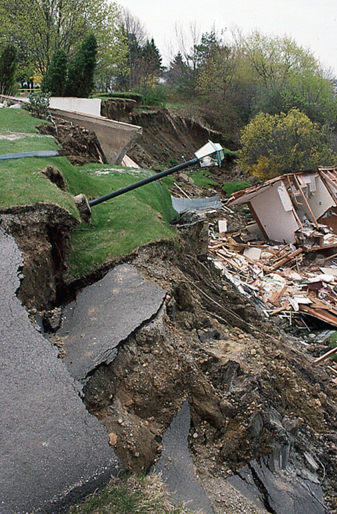
On April 16, 1996, a clay bluff failed in Rockland, causing a landslide that destroyed two homes. Photo courtesy of Maine Geological Survey
More than a half-dozen additional landslides were large enough to make it into historical documents going back to the 1600s in places such as Kennebunk, Grafton and Westbrook.
But Spigel and other members of the Maine Geological Survey staff have been able to document more than 200 landslides pre-dating written records by using aerial images created with the “light detection and ranging” technology known as LIDAR.
The highly detailed topographical images produced by LIDAR allow geologists to see the telltale signs of a landslide that are now obscured by forests or development. The teams then determined the ages of 28 of those “prehistoric” events by using radiocarbon dating of trees and other vegetation that was carried away, buried and preserved in the landslides.
Some of the landslides occurred soon after the last Ice Age, about 14,000 years ago as glaciers retreated, depressed ground rose again and sea levels began to climb. Others were more recent, including 10 landslides that occurred about 600 years ago.
“If they were all very old, we don’t have to worry too much” about future landslides, said Robert Marvinney, Maine state geologist and director of the Maine Department of Agriculture, Conservation and Forestry’s Bureau of Resource Information and Land Use Planning. “But if they occurred sporadically over time, these are still things that we have to think about when planning.”
The geologists’ research was incorporated into the Maine Emergency Management Agency’s 2019 “Maine State Hazard Mitigation Plan,” which is necessary for federal disaster relief eligibility and mitigation planning.
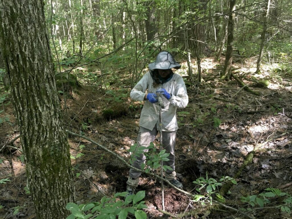
Lindsay Spigel, author of a report on landslides in Maine from the Maine Geological Survey, examines the site of a landslide in Arundel. She said, “We don’t have a lot of earthquakes in Maine on a regular basis so most of the landslides are because of wet conditions.” Photo by Amber Whittaker/Maine Geological Survey
Geologists have yet to determine why there was a cluster of landslides about 600 years ago, although earthquakes or major shifts in climate are potential culprits. Determining possible root causes would take additional time and extensive research.
But geologists have long known that a particular kind of geology in Maine, known as the Presumpscot Formation, is more susceptible to having the upper layers of earth move, sometimes slowly but other times suddenly and violently.
Created by sea mud deposited in the late-glacial period, the Presumpscot Formation features a layer of “glaciomarine” mud that weathered into a hard, tan-colored clay as it was exposed to the atmosphere when the land gradually rebounded after the heavy glaciers retreated. The blue-gray layers of clay underneath the weathered layer, however, remains soft or “gooey.” And it’s that layer that can suddenly move after, say, an extended period of very wet weather or an earthquake.
“We don’t have a lot of earthquakes in Maine on a regular basis so most of the landslides are because of wet conditions,” Spigel said.
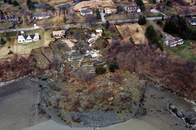
Perhaps the best-known recent landslide happened in Rockland in April 1996, when a roughly 50-foot bluff along the road leading to the Samoset Resort suddenly slumped into Rockland Harbor. The terrain moved over 400 feet, disturbed 3.5 acres of land and destroyed two homes.
The site is still visible today as a steeply sloping, grassy field leading to the mudflats along a road that is otherwise dotted with modest waterfront homes.
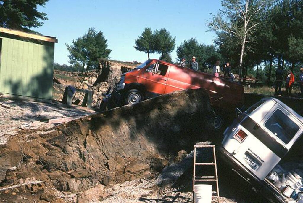
A landslide on Sept. 28, 1983, in Gorham carried 7 acres south and southwest into the Stroudwater River, taking with it a house and garage, several vehicles, a tank truck and a well drilling rig. Photo courtesy Michael E. Foley/Maine Geological Survey
Other recent events listed in the MEMA report include:
• Small-scale landslides in Brunswick in 2007 and 2016. The 2007 slide, which followed the infamous “Patriot’s Day storm,” claimed one house.
• A 2006 landslide along the Penobscot River in Greenbush that threatened part of Route 2.
• Landslides in 2005 and 2019 along the same stretch of the Merriland River in Wells, resulting in the loss of a house.
• A 1983 landslide along the Stroudwater River in Gorham – potentially triggered by well-drilling activity – that destroyed a house under construction.
The largest landslide in recorded Maine history was the one that blocked the Presumpscot River in Westbrook in the early morning hours of Nov. 22, 1868.
Roughly 20 acres suddenly slid downhill, eventually spreading out over 34 acres and along a half-mile of the river. Just upstream, workers in the Cumberland Mills paper mill – today operating as Sappi North America’s facility – scrambled to avert disaster as waters up to 15 feet deep flooded the basement and threatened boilers and other machinery.
Men eventually re-dug a channel for the river to flow through the mud, thereby sparing the mill from more serious damage. But opportunists swooped in to harvest trapped eels and tortoises while curious locals trekked to the site to gawk.
“Yesterday the scene at the great land slide at Cumberland Mills was visited by hundreds of people, who were well repaid for their jogging over bad roads and through the mud,” read a report in the Nov. 24, 1868, edition of the Portland Daily Press.
Other landslides only come to light during modern-day construction, which is what happened in 2007 while Mercy Hospital expanded its campus along the Fore River in Portland’s Western Promenade.
Excavators uncovered massive spruce trees and other ancient vegetation deep underground. Radiocarbon dating told geologists that those trees were likely buried about 13,500 years ago in a landslide caused by a massive slippage of the Presumpscot Formation in that spot.
In fact, Portlanders walking or enjoying the view from the Western Promenade today are standing at the top of the remaining bluff, part of which fell and carried away those ancient spruce 13,500 years ago.
Spigel and Marvinney said they hope the recent study and ongoing look at Maine’s landslide-prone geology will prompt town planners to consider the underlying geology as they zone areas or review requests for subdivisions or large-scale development, especially in places like river valleys.
The challenge, Marvinney said, is that while they now have a better handle on where landslides have happened in the past, they can’t predict when or if they will happen in the large sections of Maine with Presumpscot Formation geology.
“Rockland demonstrated that these things can happen today,” Marvinney said. “It’s an ongoing hazard in the state. We are learning more about it and the study brought us a long way to understanding … but we can’t predict them.”
Send questions/comments to the editors.

Comments are no longer available on this story