


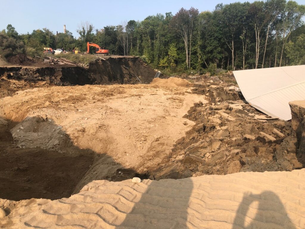
City Planner Jennie Franscheschi was on scene within an hour of the landslide, grabbing this photo from the opposite side of the origin point of the slide. Photo courtesy of Jennie Franscheschi
WESTBROOK — Westbrook city officials are warning people to keep clear of the site of a landslide that dammed the Presumpscot River last week.
The landslide, which occurred Wednesday, Sept. 16, covered about four acres and blocked the river near 161 Warren Ave.
By Monday, the city had lifted a state of emergency following advice from the Army Corps of Engineers. However, the city is still asking people to avoid the area because trees are still falling as a result of the slide.
“The area affected is very large and even created new islands within the river, which was quite something to see happen here in our community,” Mayor Mike Foley said. “We are glad there is no longer any immediate dangers associated with this incident and we will continue to monitor this as it naturally progresses.”
Fire Chief and City Health Officer Andrew Turcotte said that the water has found its way “around or through” the blockage.
On Monday, Foley said that the Army Corps recommends letting “nature take it’s course,” as water will likely continue to make its own paths.
“It is possible to have a section of that dam break open and surge of water and localized flooding, but at this time its small potential,” said Director of Engineering and Public Services Eric Dudley on Sept. 17.
According to Maine Geological Surveyor and landslide expert Lindsay Spiegel, the slide likely happened as a result of a natural formation of clay known as the “Presumpscot Formation” giving way.
Along with the clay, trees and equipment from nearby businesses gave way. However, there is no threat to the quality of water, officials said.
Spiegel also mentioned that the site of the slide is across from where a historic landslide took place in 1868.
According to Westbrook Historical Society records, the previous landslide “during the night had moved land, trees and all a distance estimated by many at 200 yards. In the course of the event, the channel of the Presumpscot River had been moved some 300 feet.”
According to Spiegel, landslides are common in Maine, but many smaller scale landslides may go unnoticed.
Westbrook itself is in an area that was riddled with pre-historic landslides, Foley said Monday.
In a paper written by state Geologist Walter A. Anderson of the Maine Geological Survey, Dept. of Conservation, and referenced in the Historical Society dialogues, “evidence also exists which suggests the occurrence of a massive prehistoric landslide in the Saccarappa area of present-day Westbrook. This slide is thought to have encompassed two hundred acres and redirected the flow of the Presumpscot River northward away from an assumed course through the Fore River estuary.”
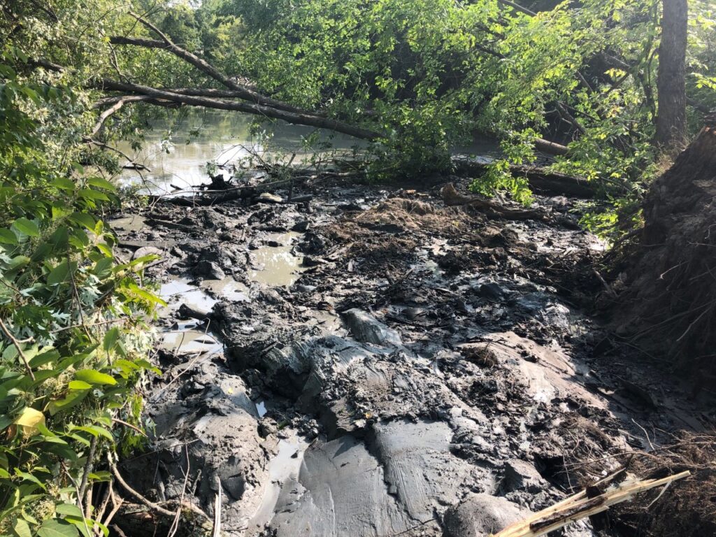
“(This) picture (is) immediately following slide showing clay completely clogging the river, no flow (was) going through river at this time,” according to City Director of Planning Jennie Franscheschi, who was on the site of the landslide almost right after it happened. Courtesy photo
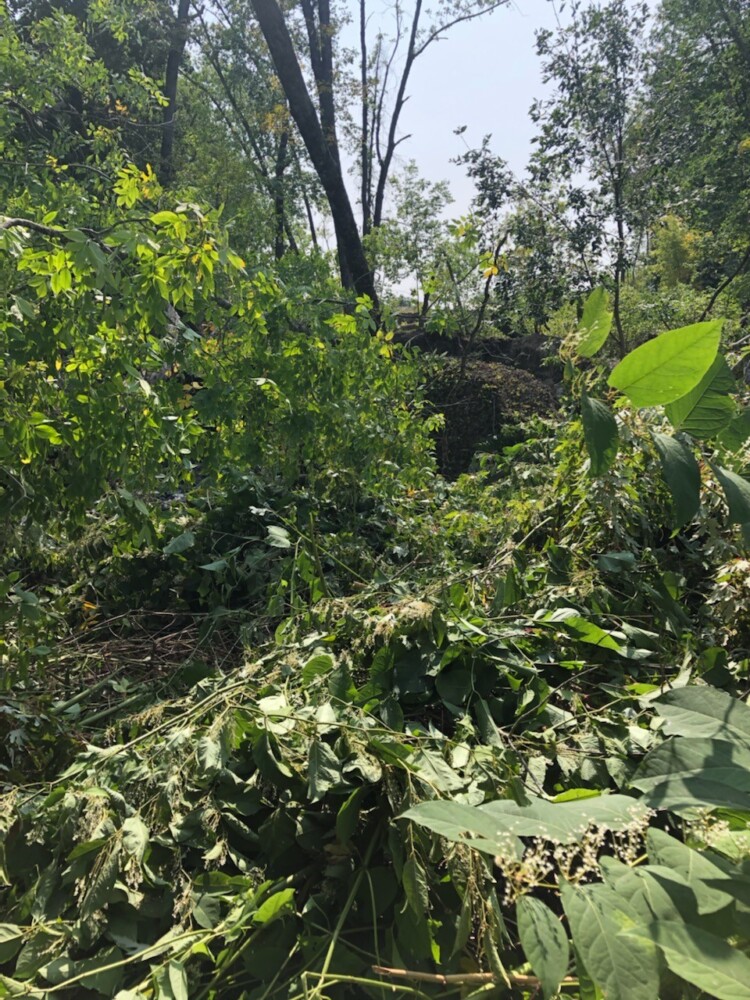
A photo taken by Fire Chief Andrew Turcotte from the Sappi side of the river. “As you can see, I am standing where the riverbank would have been, however there are trees and debris where the water of the Presumpscot would be flowing,” Turcotte said. Photo courtesy of Andrew Turcotte
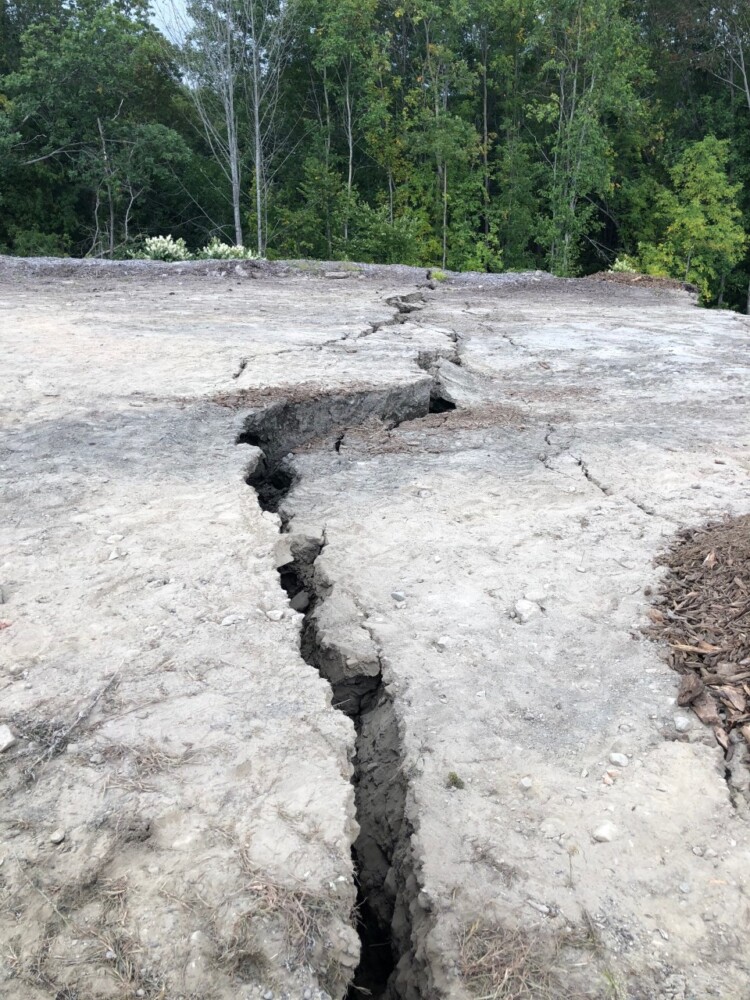
A crack on the ground at Delta Realty, near the landslide. The crack likely formed when the land gave way. According to Fire Chief Andrew Turcotte, some of the banks by the property went down 60 feet following the slide. Courtesy photo
Comments are not available on this story.
Send questions/comments to the editors.
