

While everyone on the internet has been solving Wordle puzzles, your local meteorologists have been trying to solve the puzzle that is Monday’s storm.
At this point, I expect a fairly significant winter storm for most of Maine.
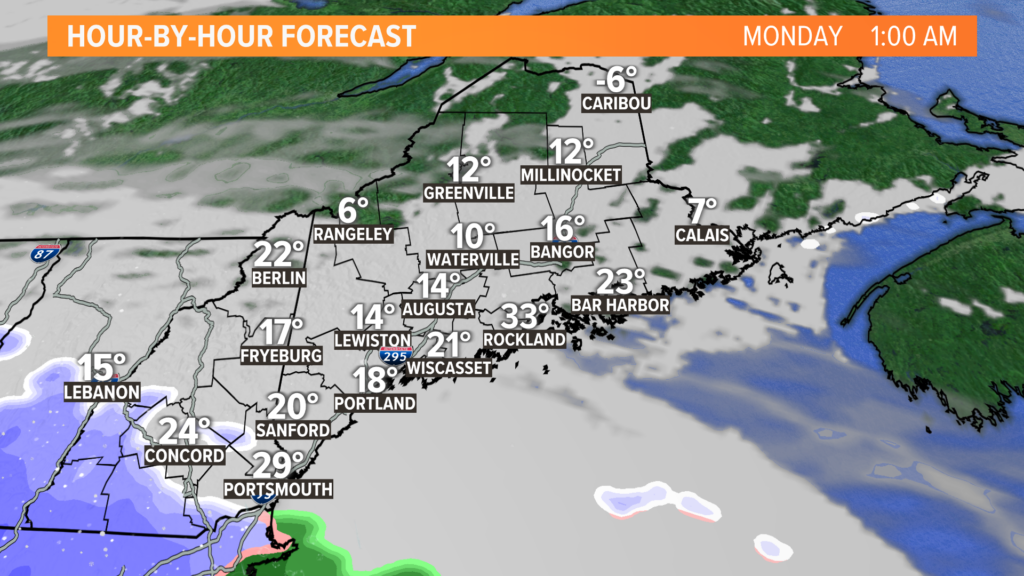
Sunday starts off wicked cold again, with most towns near or below zero.
NEWS CENTER Maine
That sets the stage for just how cold things will be as clouds thicken up Sunday evening.
Given this cold air, the entire storm starts as snow, even at the coastline.
NEWS CENTER Maine
All week long, I spoke about the possibility of two storm tracks for Monday’s storm.
With all of the data I have now, I am feeling pretty confident in a track that takes the storm inland a bit. This complicates the forecast, as a burst of heavy snow in the morning will eventually change over to rain across the coastline with some mixing inland.
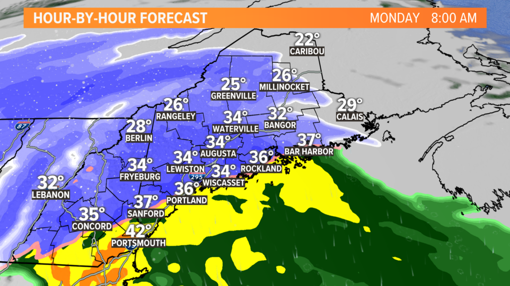
Take a look at Monday morning. Even as early as 8 a.m., coastal temperatures will be trying to get above freezing. I think this model is a little too fast, though. I expect sub-freezing temps for all of Maine and New Hampshire through the morning.
NEWS CENTER Maine
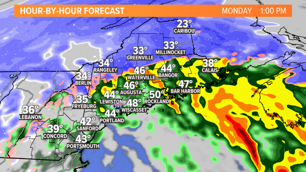
The warm does eventually win, though. Even here, I think it’s too fast. Expect the foothills to stay mostly snow. Bangor will, however, likely see a shift to rain.
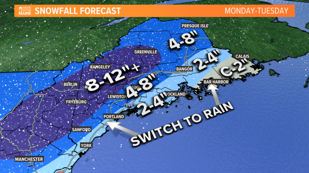
So, just how much snow will this drop?
NEWS CENTER Maine
Here’s what I am thinking for totals. The highest chance at seeing a foot is across the foothills of western Maine. The ski areas could really use something like this, so it’s a good thing for people who depend on winter weather for a living.
The corridor from Sanford to Augusta will see a bit of heavy snow before a bit of mix or even rain takes over. Given the temperature profiles, it might end up as sleet or freezing rain.
Should there be any icing, this is the spot to watch.
I think that central Maine will also probably deal with some wet, heavy snow. This might cause additional stress on trees and powerlines, so watch for potential outages.
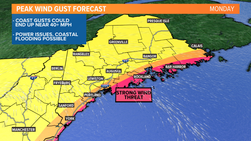
At the coastline, snow gives way to rain. While snow totals will be lower here, impacts are still going to be felt from this storm. Those impacts come from potentially strong wind gusts.
NEWS CENTER Maine
Given the current forecast, wind gusts pick up on Monday in the morning and afternoon, especially along the coastline.
Gusts could approach or exceed 40 mph out of the south. Widespread power outages seem unlikely, but there will still probably be some issues that pop up.
I am a little more concerned for areas near I-95. With some wind gusts and a heavy, wet snow, there might be a few more power issues that pop up here. We’re still fine-tuning the forecast and will have updates as soon as they’re available.
Last, but certainly not least, is the potential for some minor coastal flooding. Given the southerly wind direction, some flood prone areas along the coast could see inundation around high tide.
Here’s your quick breakdown:
What
An impactful winter storm rolls through on Monday. Snow, wind gusts, and some minor coastal flooding are all on the table.
Timing
Snow begins around sunrise Monday in western Maine, an hour or so after sunrise in eastern Maine.
Snow will fall in the mountains the whole day. At the coast, snow will switch to rain by the early afternoon. In between, expect some mixing to develop.
The entire storm wraps up late Monday with some lingering flakes into Tuesday morning.
Impacts
Tough travel is the biggest impact. Watch for slick roads, low visibility, and maybe some debris in the roads.
Power outages are also an issue, specifically near the coastline. Wind gusts and some heavy, wet snow will stress trees and powerlines. I still am not expecting widespread issues at this time.
Minor coastal flooding will be possible during the high tide cycles on Monday.
I know the timeline details are still a little muddy, but I am waiting until tomorrow to nail down specifics (switch to rain, switch to sleet, etc). Keep an eye out for that blog.
– Mike Slifer, @MikeSliferWX
Copy the Story LinkSend questions/comments to the editors.

Success. Please wait for the page to reload. If the page does not reload within 5 seconds, please refresh the page.
Enter your email and password to access comments.
Hi, to comment on stories you must . This profile is in addition to your subscription and website login.
Already have a commenting profile? .
Invalid username/password.
Please check your email to confirm and complete your registration.
Only subscribers are eligible to post comments. Please subscribe or login first for digital access. Here’s why.
Use the form below to reset your password. When you've submitted your account email, we will send an email with a reset code.