

Throughout the week, we’ve been talking about this storm’s potential. There were two distinct possibilities: a classic nor’easter with snow for all, or a messy storm with wintry mix and strong wind.
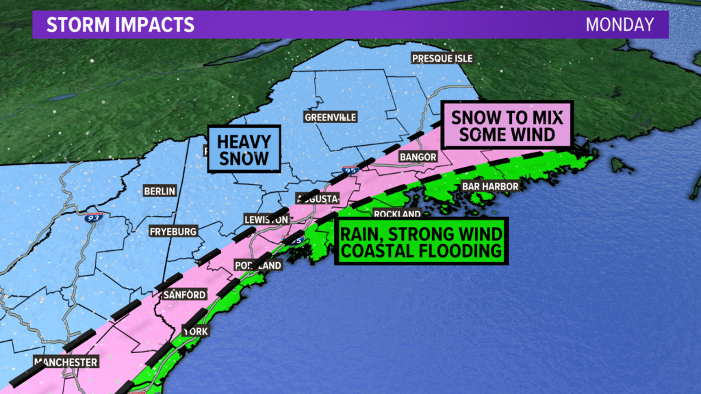
Unfortunately, the latter is what’s coming our way. Let’s start with a general outline of threats. If nothing else, this potential impact map is a great place to start.
NEWS CENTER Maine
The coastline will probably end up with the biggest issues, but central Maine needs to be on alert for outages and some downed branches, too.
Thankfully, this should be pretty good snow in the mountains. Let’s build that base up so we can ski right into April!
Timing
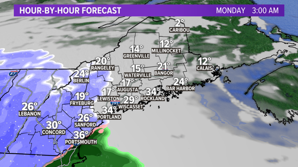
Here is an idea of the timing for Monday’s storm.
NEWS CENTER Maine
Shortly after midnight, snow will begin across western Maine.
Areas right along the coast will start as snow, but there could be a switch to rain even before sunrise, given the easterly wind.
NEWS CENTER Maine
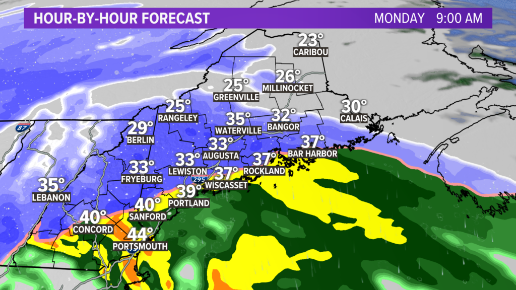
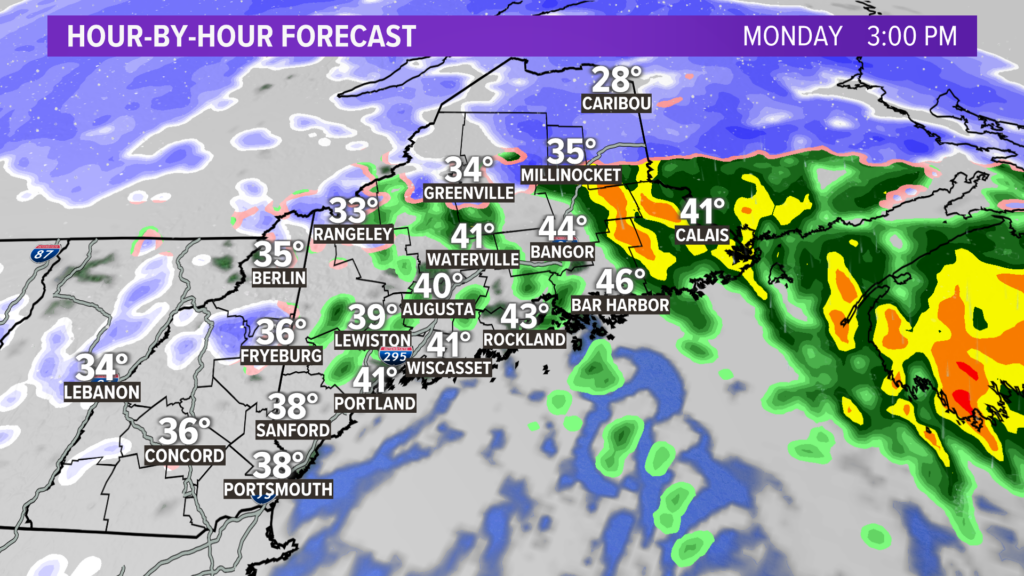
By 9 a.m., heavy snow will be pushing north.
Inland areas, including parts of the Midcoast and Cumberland and York counties, will likely be dealing with very heavy snow.
Snowfall rates could reach 1-3″ per hour, which will quickly cause roads to become snow covered and make travel very difficult.
Whiteout conditions are possible on US 302, the Maine Turnpike, coastal US 1, and US 2 during the morning commute on Monday.
Snow also begins in Bangor around this time.
Watch for wicked strong wind gusts along the coastline west of Wiscasset during this time frame, too. I’ll detail the wind threat below.
NEWS CENTER Maine
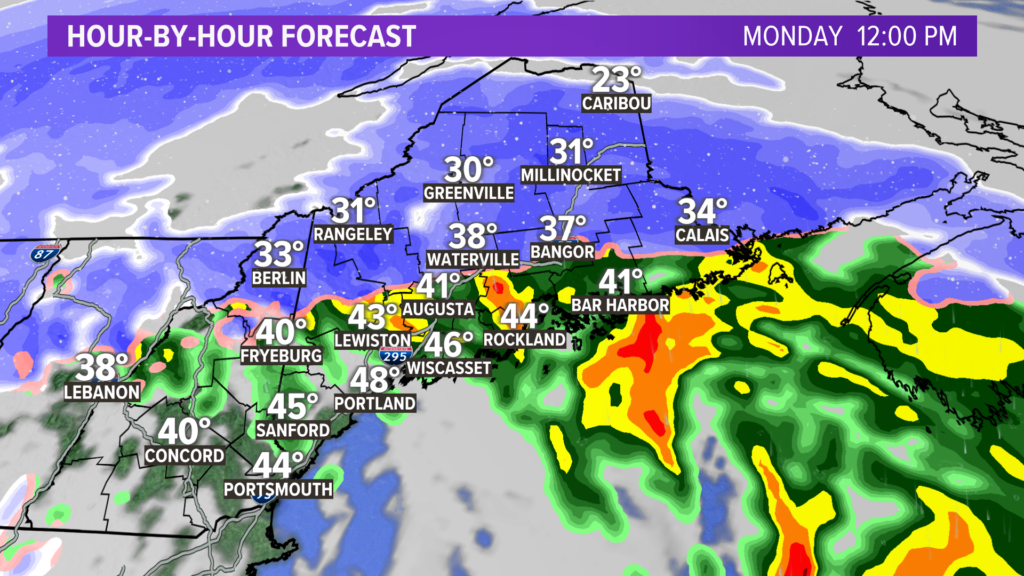
The rain/snow line keeps pushing inland. At noon, areas along and north of Route 2, along with Bangor, will switch to sleet and maybe even rain.
Something to note: since the heaviest snow comes at the beginning of this storm, these areas will likely have already reached their forecast totals before the rain begins.
Travel continues to be messy. Wind gusts pick up along the Midcoast and Downeast.
NEWS CENTER Maine
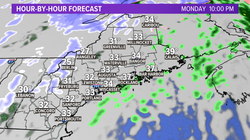
Just about three hours later, precip will have wrapped up for most of western, southern, and central Maine.
As was the case in western areas, most of the forecast snow will have already fallen by this point in time. Any lingering precip will generally be sleet or light rain.
NEWS CENTER Maine
Most will see precip wrap up entirely from this storm around 7 p.m. A few lingering showers are possible as colder air moves in, but the significant part of the storm will be over.
Impacts
There are two big impacts at the coast with this one: wind gusts and potential coastal flooding.
NEWS CENTER Maine
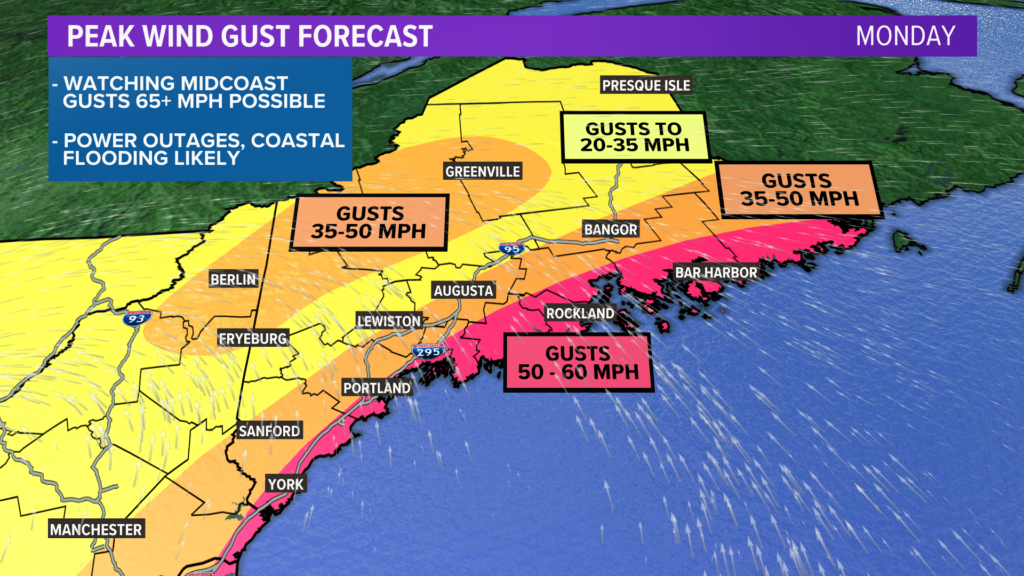
Wind gusts are going to be very strong out of the east and southeast. This is one of the most impressive wind signals I have seen since I began my tenure here at NCM.
Most coastal spots will see gusts easily reach and exceed 50 mph, and some spots may even see gusts to or over 60 mph.
Spots just inland from the coast will be windy, too, but the possibility of gusts over 50 mph drops off quickly. The higher peaks may also see a few stronger gusts mixed in, leading to some isolated power issues.
NEWS CENTER Maine
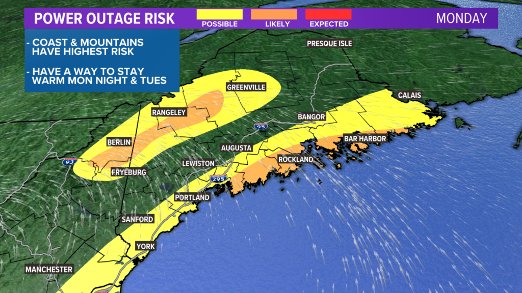
When we talk about wind of this magnitude, it’s expected that power outages will not be too far behind.
The highest risk is going to be along the coastline, where the strongest gusts occur.
There is also going to be a secondary risk area in the mountains, where strong wind gusts and heavy snow overlap.
NEWS CENTER Maine
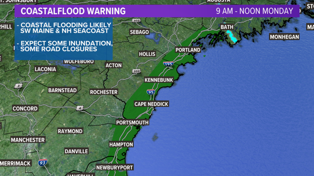
On top of that, there’s a coastal flood warning out for parts of the southwestern Maine coastline and the New Hampshire Seacoast.
This is going to be mostly during the morning high tide, as water levels climb and coincide with a strong southeasterly wind.
Low-lying roads, even some coastal businesses or homes, and other vulnerable areas will likely deal with some minor coastal inundation.
A few road closures are definitely on the table for Monday morning.
Timing on this threat is mostly between 9 a.m. and noon on Monday.
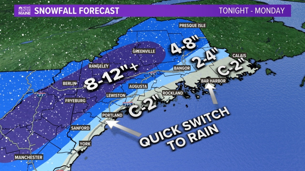
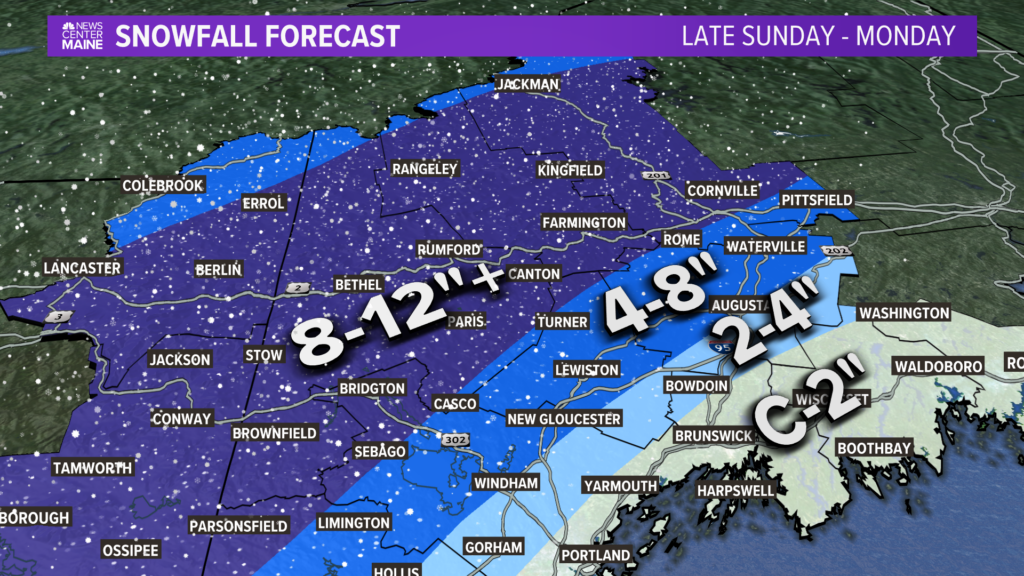
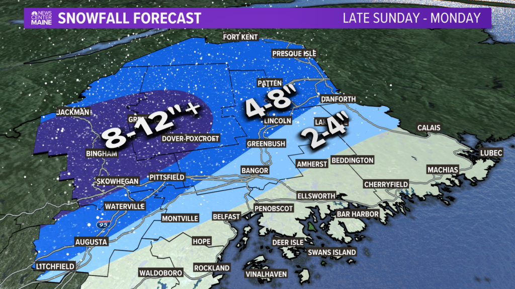
Snow Totals
NEWS CENTER Maine
Last, but certainly not least, is the snow totals. I’m giving this its own section because I know a lot of people are clicking this article just for this map. And maybe they were hoping I snuck a picture of my dog in. But, alas, I did not…this time.
NEWS CENTER Maine
The highest totals will be across interior sections of western Maine. The snow gradient across York county alone will be really impressive…the coast gets next to nothing, while inland areas pick up almost a foot. Maybe even over a foot, in some spots!
The Lewiston to Augusta corridor has been bumped up slightly. I think the leading edge of the snow is just going to dump snow, which should put this area into the 4″ pretty quickly (maybe even up to 8″) before the switch happens.
NEWS CENTER Maine
Since the terrain is somewhat less complicated in the eastern half of the state, I expect there will be less of an issue getting warm air in. This will bring snow totals down a bit, thanks to increased mixing potential. Parts of Somerset and Piscataquis counties should still get buried, though.
Takeaways
Power outages and coastal flooding are going to cause some issues. Have a plan to stay warm as cold air returns Tuesday followed by an Arctic shot at the end of the week.
Try not to travel, is possible. I think it’s a good thing kids are home from school tomorrow given this forecast.
Never, ever, touch powerlines on the ground.
That’s all I’ve got. Be kind to each other and make sure you’re thinking about resources available to you should you lose power from this.
NEWS CENTER Maine
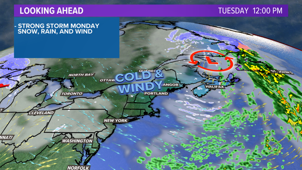
Tuesday will be cold and windy. Temperatures only make it into the 20s during the day.
NEWS CENTER Maine
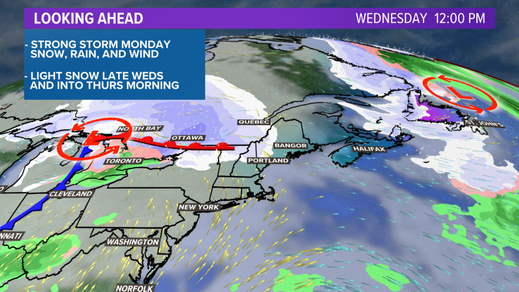
Light snow moves in Wednesday afternoon and sticks around right into Thursday. Behind this weak system, another shot of Arctic air settles into Maine.
Classic January.
Don’t look now, but we might have another significant storm to talk about next Sunday or Monday.
– Mike Slifer, @MikeSliferWX
Send questions/comments to the editors.

Success. Please wait for the page to reload. If the page does not reload within 5 seconds, please refresh the page.
Enter your email and password to access comments.
Hi, to comment on stories you must . This profile is in addition to your subscription and website login.
Already have a commenting profile? .
Invalid username/password.
Please check your email to confirm and complete your registration.
Only subscribers are eligible to post comments. Please subscribe or login first for digital access. Here’s why.
Use the form below to reset your password. When you've submitted your account email, we will send an email with a reset code.