

A tandem shredder team paddles Austin Stream. Ron Chase photos
Every cloud has a silver lining. Given the rainy, foggy, humid weather we’ve experienced over the past month, that’s likely an adage many find difficult to embrace. However, there has indeed been a silver lining for one group: whitewater boaters. For several weeks, the rivers and streams have been raging.
For many paddlers, choosing from a wide selection of whitewater options has been the larger problem. In some cases, there has been too much water. The high water levels also provide opportunities to navigate streams that are rarely available.
My friends and I paddled three consecutive days in late June. Our last choice was Temple Stream in Temple and Farmington, a stimulating first descent for me. A few hours after we completed our trip on Temple, the area received a deluge of rain. We were fortunate; flooding resulted in some areas.
Adam Chase probes one of the many rapids.
My son, Adam, and I had our sights on the Dead River for the first day of July. Heavy rains had overfilled Flagstaff Lake, which feeds the Dead. Flagstaff Lake Dam operator Brookfield Renewable announced water levels would be unusually high. We decided to pass.
Our research indicated infrequently paddled Austin Stream in Bingham was flowing at a quality level. A Penobscot Paddle & Chowder Society trip announcement resulted in four enthusiastic Chowderheads electing to join us. The six of us met at the Austin Stream takeout in Bingham on another gray, partly rainy day. Our group consisted of three kayakers, a solo canoeist and a tandem team in a two-person inflatable vessel called a shredder.
The lower portion of Austin Stream is a 6-mile stretch of almost continuous whitewater. The gradient in the first 4 miles is a challenging 100 feet per mile. While there are no dramatic falls, the stream consists of a series of steep boulder-strewn rapids that require attentive rock dodging. The American Whitewater Association rates it Class III/IV.
There is a downside to paddling Austin Stream: Locating a suitable place to launch is no easy task. The trip begins in a deep valley. Reaching the river requires bushwhacking down a steep, densely wooded embankment from Deadwater Road. After some exploration on the rough, dirt road, we found an acceptable location to lower our boats to the stream.
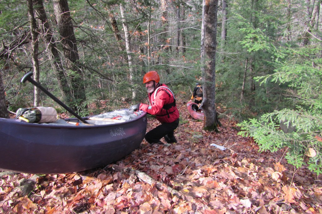
Paddlers lower their boats down the embankment to Austin Stream.
Once the strenuous carry was completed, we arrived at a precipitous rapid tumbling through a boulder garden. Finding a safe place to launch the boats was our next challenge. Since there were no calm eddies along the shore, we had to slide our crafts directly into the fast-moving current ready to paddle.
Safety concerns were paramount. The most significant danger in long, continuous whitewater is the risk of encountering fallen trees, logs or other debris called strainers. Capsizing and swimming was another potential hazard. Since the rapids are steep and shallow, rolling a canoe or kayak is problematic. Swims would likely result in long, punishing ordeals with the risk of injury and the possibility of losing boats and paddles. Our goal was to remain upright while carefully watching for perilous obstructions.
Adam and I were the only Austin Stream veterans, so we alternated probing the rapids. Boat scouting navigable routes between the ubiquitous boulders while avoiding boat-flipping pour-overs was our primary concern. Since eddies were rare, finding calm spots to regroup was a secondary objective.
Our descent began with a flourish of exhilarating whitewater activity. Maneuvering through a continuum of invigorating rapids, the powerful current propelled us swiftly downriver.
Rock dodging is common descending Austin Stream. Ron Chase photo
Approaching an island, Adam spotted a strainer blocking the entire left side. We were able to negotiate through a narrow channel on the right. Fortuitously, that was the only major hazard we encountered.
We turned a bend at about mile 4 and entered the most complex rapid of the day. Pockmarked with holes on the left and center, we were able to skirt down an abrupt passage far right. That descent marked the end of the continuous whitewater and the gradient began to diminish.
Sporadic Class III rapids continued to an area where swirling currents carried us under a bridge in Bingham. Easy whitewater followed for the remaining mile to the takeout completing an extremely entertaining river adventure. And everyone remained upright!
My book, “Maine Al Fresco: The Fifty Finest Outdoor Adventures in Maine,” relates nine more exciting Maine whitewater escapades and six multi-day river trips.
Ron Chase resides in Topsham. His latest book, “Maine Al Fresco: The Fifty Finest Outdoor Adventures in Maine,” is available at northcountrypress.com/maine-al-fresco or in bookstores and through online retailers. His previous books are “The Great Mars Hill Bank Robbery” and “Mountains for Mortals – New England.” Visit his website at ronchaseoutdoors.com, or he can be reached at ronchaseoutdoors@comcast.net.
Comments are not available on this story.
Send questions/comments to the editors.


