


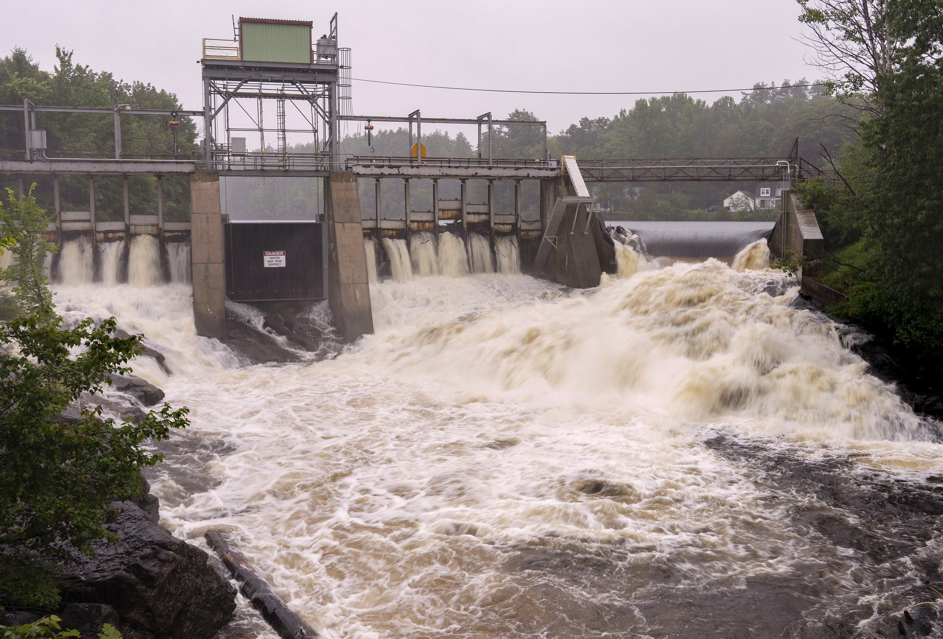
Water surges over a dam on the Saco River in Hollis on Tuesday. Heavy rains caused rivers and streams to swell and created flooding some in areas. Gregory Rec/Staff Photographer
A slow-moving storm dumped 5 inches of rain on parts of the state Tuesday, flooding roads and causing rivers to surge in southern and central Maine before moving east in the late afternoon.
The National Weather Service issued a flash flood warning from northern York County and the Portland area through Lewiston and Augusta to Skowhegan before downgrading it to a flood advisory in most areas by 3 p.m. The region’s last remaining flash flood warning, between Scarborough and Farmington, expired at 3:15 p.m., forecaster Sarah Thunberg said. Most of the state is under a flood watch advisory into Wednesday as scattered showers or thunderstorms were possible into the evening.
Some areas in northwest Cumberland County and Androscoggin County had recorded about 5 inches of rain by late Tuesday afternoon. Portland experienced heavy downpours, but total rainfall in the city was just over 1 inch as of Tuesday evening.
While heavy rains and high water levels in rivers caused localized flooding in interior communities, Thunberg said the risk of sudden and severe washouts had largely passed by midafternoon as the storms moved past Penobscot Bay to the east.
In New Gloucester, Legrow Road was closed and Lewiston Road was restricted to one lane because of flooding. In Auburn, Park Avenue was closed and West Auburn Road was flooded and impassable, the weather service said. A section of Route 237 at the Gorham and Standish line was closed because of flooding. And in Falmouth, Blackstrap Road was closed from Babbidge Road to Hurricane Road, the town’s public safety department said.

A section of Legrow Road in Gray was closed to traffic after flooding on Tuesday. Derek Davis/Staff Photographer
The weather service warned of flash flooding around small creeks and streams, urban areas, highways and streets, as well low-lying areas or areas with poor drainage. Some locations that were susceptible to flash flooding included Portland, Lewiston, South Portland, Auburn, Biddeford, Brunswick, Augusta, Westbrook, Bath and Gardiner, including the Interstate 295 corridor between Portland and Augusta, the advisory said.
Meteorologist Jon Palmer described the weather pattern as “training,” where storms line up on top of each other, often moving over the same area and dumping heavy rain on that area in a short period.
Cumberland County Emergency Management Agency Director Michael Durkin said on Tuesday that the agency was monitoring the Presumpscot River in Falmouth, the Royal River in Yarmouth and Stony Brook in Casco.
“All three of them are high, obviously, but they’re lower than the state they were in on July 30, when we had the last big push with the storm coming through,” he said. “We’re expecting as the rain comes through, they’re going to kind of keep on rising throughout the afternoon.”
Durkin suggested residents in affected areas should avoid the roads if possible. If a driver does come across a flooded area, they should not attempt to drive through it, even if the water looks shallow.
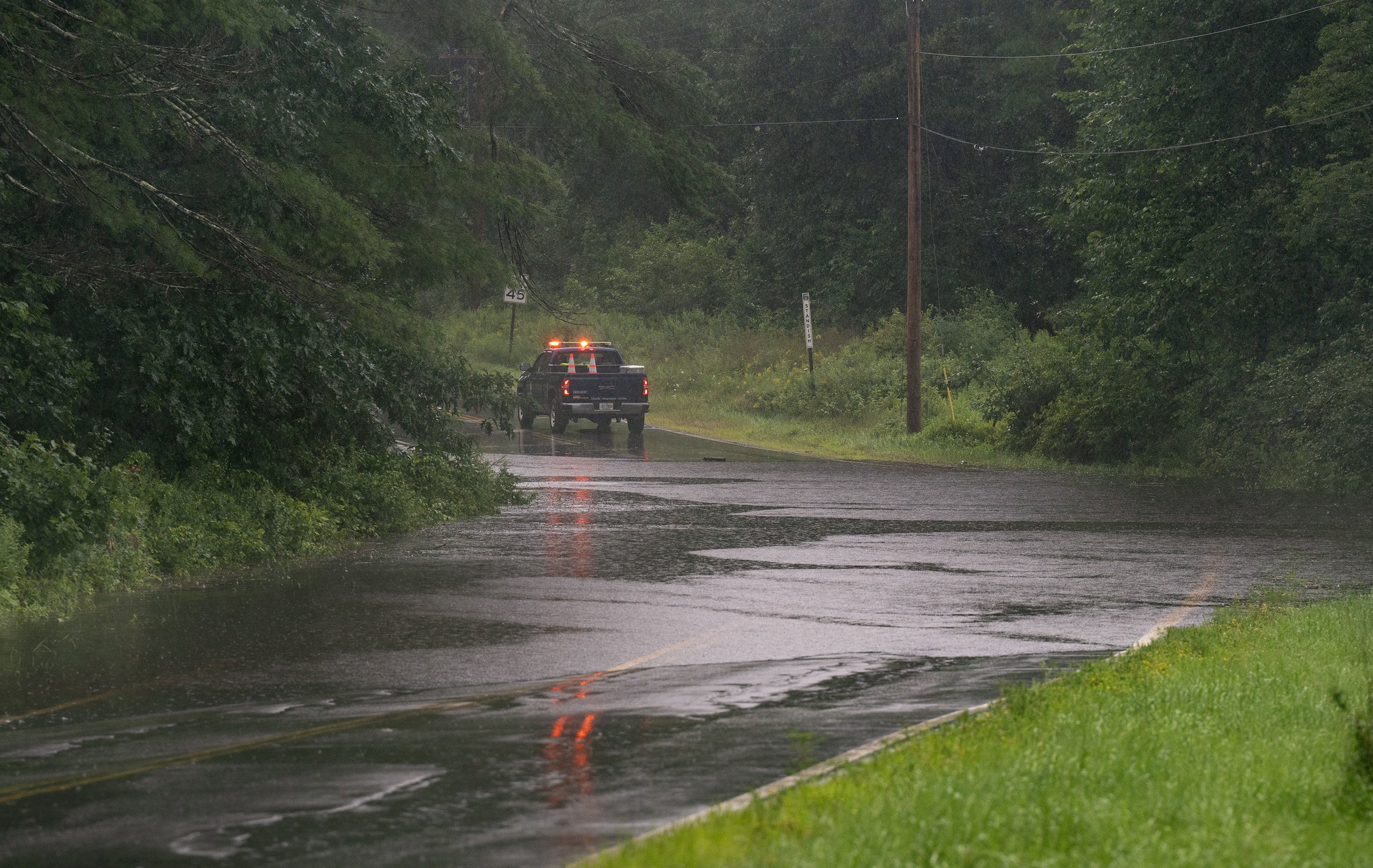
A Maine Department of Transportation truck blocks Sebago Lake Road on the Standish/Gorham town line, where the road was closed because of flooding on Tuesday. Gregory Rec/Staff Photographer
Art Cleaves, director of the York County Emergency Management Agency, said at 12:15 p.m. that he expected to hear reports of minor flooding in the county’s northeast quadrant “any time now.” But based on the forecast, he did not expect the Saco River to overflow.
“Each of the storms that have happened since May have taken us right to the brink of what we would call major flooding or major washouts,” he said. “I don’t know how much more rain we’re going to get this afternoon, but it puts us right on the edge again.”
A spate of storms this summer has resulted in higher-than-average rainfall in southern Maine, according to National Weather Service data. Portland saw 15.37 inches of rain in May, June and July, 36% more than the area’s historical average for that period. The wet pattern is expected to continue with a chance of showers Thursday night.

Vehicles navigate a flooded section of Lewiston Road in New Gloucester on Tuesday afternoon. Derek Davis/Staff Photographer
The heavy summer rains have been linked to a combination of weather patterns and changes in the climate, including warmer ocean temperatures that can contribute to more severe storms. The pattern is consistent with predictions that climate scientists have made about how a changing climate will affect the Northeast region.
According to research by Dartmouth College climate experts, weather events yielding over 1.5 inches of heavy precipitation are expected to increase by 52% by the end of the century. This is because the warmer the air is, the more water vapor it can hold. And, according to National Oceanic and Atmospheric Administration, temperatures in the North Atlantic have been consistently much higher than historical averages all summer.
While Maine has been lucky to avoid major flooding like the washouts and flood damage that occurred in Vermont last month, Cleaves warned that the high water levels in local rivers could still prove dangerous, especially as the peak of the Atlantic hurricane season arrives in the coming weeks.
Staff Writer Emma Kilbride contributed to this story.
Copy the Story LinkSend questions/comments to the editors.

Success. Please wait for the page to reload. If the page does not reload within 5 seconds, please refresh the page.
Enter your email and password to access comments.
Hi, to comment on stories you must . This profile is in addition to your subscription and website login.
Already have a commenting profile? .
Invalid username/password.
Please check your email to confirm and complete your registration.
Only subscribers are eligible to post comments. Please subscribe or login first for digital access. Here’s why.
Use the form below to reset your password. When you've submitted your account email, we will send an email with a reset code.