


Two men take a look around Thursday at the gravel pit along Gracelawn Road in Auburn. Property owner John Gendron has proposed a 1,100-unit housing development on the property, but the level of development will depend on the watershed boundary around nearby Lake Auburn. Daryn Slover/Sun Journal
AUBURN — State officials have approved a new Lake Auburn watershed boundary along the Gracelawn Road parcel that has been at the center of an ongoing debate over water quality in the Twin Cities.
Officials from the Maine Drinking Water Program issued a letter this week agreeing with a recent report that said a conservative watershed boundary can be established with current data, but that further investigation would be needed to move the boundary northward toward Lake Auburn.
The conservative line, referred to as “DWP (Drinking Water Program) potential boundary” in consultant CDM Smith’s previous report, runs just south of the main gravel pit area operated by Gendron & Gendron Inc.
The current boundary, which follows mostly along Gracelawn Road, has previously been recommended to shift northward toward the lake, based on previous data on groundwater and stormwater flows. The city rezoned the land based on the previous recommendation, leading to a proposed development by property owner John Gendron.
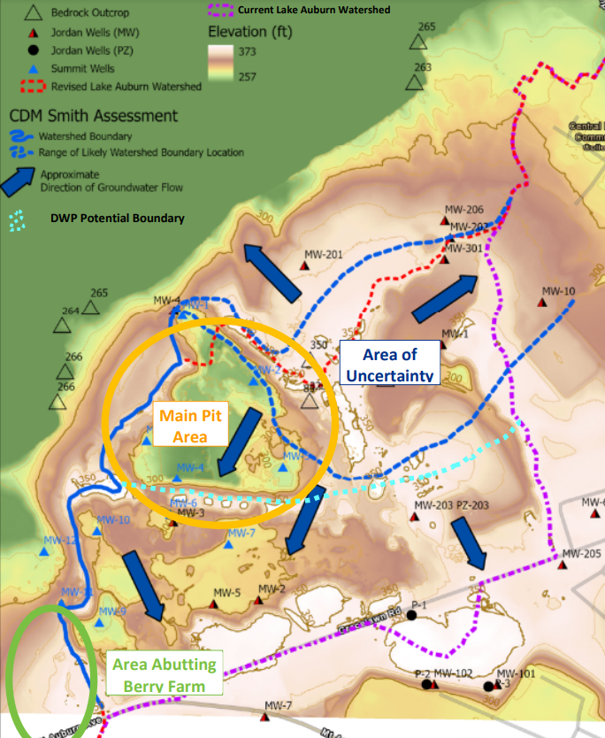
A map from consultant CDM Smith shows the Gracelawn Road parcel at center of a debate over watershed rules. The Maine Drinking Water Program approves of a new watershed boundary, shown in light blue, to protect Lake Auburn that is indicated in green at upper left. Screenshot of map
However, the prospect of new development and questions about its impact to the lake have led to a prolonged debate, citizens’ petition and lawsuit over whether the watershed boundary should be changed.
Susan Breau, a hydrogeologist and water resources team leader at the Maine Drinking Water Program, said in the letter that the Drinking Water Program will not challenge the conservative boundary “based on our current understanding of local hydrogeology,” but that it “agrees that further investigation would be needed to establish a boundary closer to Lake Auburn.”
The letter goes on to recommend additional testing that could be used to “further refine the boundary location” in the future.
Mike Broadbent, superintendent of the Auburn Water District, said he expects the board of trustees will discuss the approved boundary at its next meeting Sept. 20.
Zach Lingley, a consultant working with Gendron on the proposed development, sent a statement on behalf of the development team Thursday. He said the developers plan to pursue the additional testing in order for the boundary to be further amended.
“We are happy to see that there is now consensus on the watershed boundary,” the statement said. “This affirms what we’ve known for over a year, that the gravel pit is outside of the watershed. The tests suggested by the Maine Drinking Water Program have long been a part of our plan for developing the property, so we would readily comply with those requirements. We would like to thank the city of Auburn for their thoughtful approach and continued diligence throughout this process.”
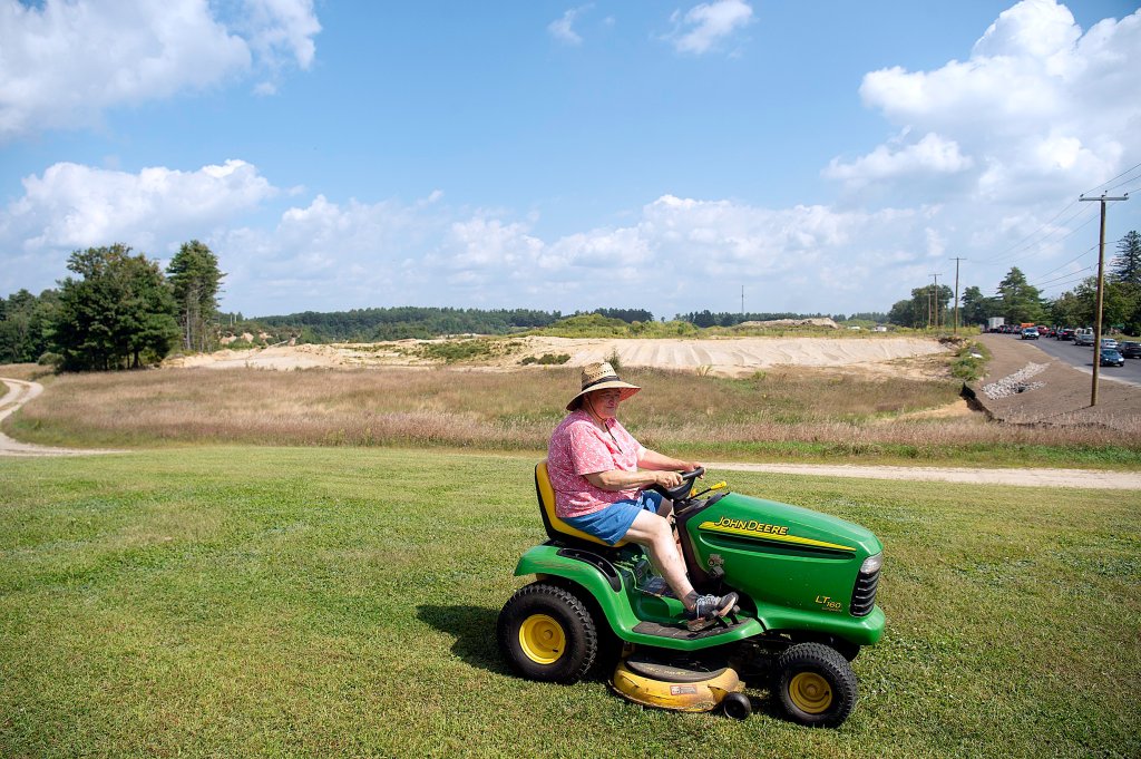
Jane Berry-Dinsmore, owner of The Berry Farm, mows her lawn Thursday along Mt. Auburn Avenue in Auburn. Her 22-acre farm abuts property owned by John Gendron, who has previously proposed a 1,100-unit housing development. “They have been working right up to my property line,” she said. “I do understand the problem. I know we need housing, but if it messes up the lake, we will all pay the consequences.” Berry-Dinsmore said she is “hoping for a buffer zone of fast-growing trees. Tall trees.” Daryn Slover/Sun Journal
The letter from Breau does not specifically state that the gravel pit is outside the watershed, it states that “it is possible that additional information may be required to establish a boundary closer to Lake Auburn, as determined by the (Drinking Water Program) at the time of that investigation.”
Earlier this year, Gendron applied for a traffic movement permit from the Maine Department of Transportation, which included a master plan for the site that shows roughly 1,100 apartments and townhomes on 88 acres.
The development, if ultimately approved, would likely be done in phases, but the scope would depend on the watershed boundary.
Broadbent previously described the state’s recommended boundary as “an irrefutable boundary,” where any water south of the boundary does not go toward the lake and anything north would have to be further studied.
After the consultant’s report was released, Broadbent co-authored a letter to the state with Lewiston Water Division Superintendent Kevin Gagne, asking them to review and consider the approval of the boundary.
An amended boundary could also play a role in the ongoing lawsuit between the city of Lewiston and the Auburn Water District. While Lewiston has argued that Auburn’s actions could threaten the waiver from filtration that the cities hold, Auburn has maintained that all proposed changes are based on science and that upper watershed towns are to blame for the bulk of nutrients entering the watershed.
Some Auburn officials have argued that a development with proper stormwater management at the Gracelawn site would be more beneficial than a working gravel pit.
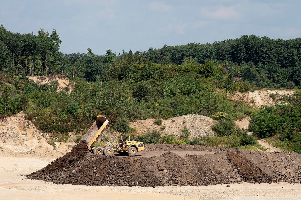
A truck unloads dirt Thursday at the gravel pit along Gracelawn Road in Auburn. Property owner John Gendron has proposed a 1,100-unit housing development on the property, but the level of development allowed will depend on the watershed boundary for nearby Lake Auburn. Daryn Slover/Sun Journal
Send questions/comments to the editors.

Success. Please wait for the page to reload. If the page does not reload within 5 seconds, please refresh the page.
Enter your email and password to access comments.
Hi, to comment on stories you must . This profile is in addition to your subscription and website login.
Already have a commenting profile? .
Invalid username/password.
Please check your email to confirm and complete your registration.
Only subscribers are eligible to post comments. Please subscribe or login first for digital access. Here’s why.
Use the form below to reset your password. When you've submitted your account email, we will send an email with a reset code.