


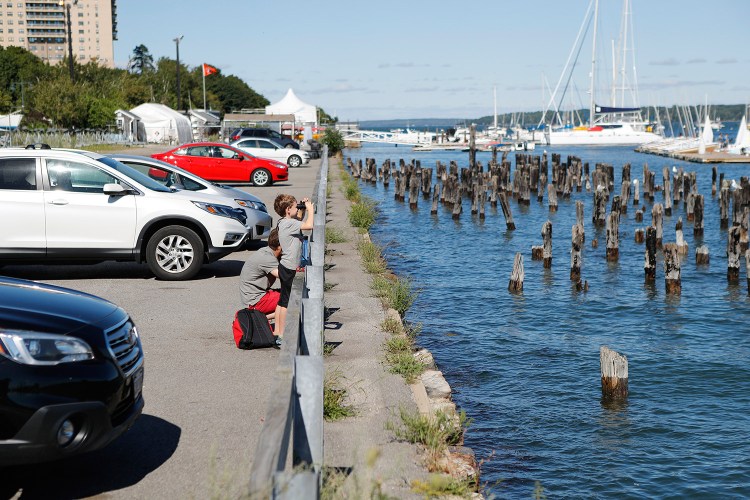
The so-called Amethyst lot is roughly 1.5 acres of broken asphalt ringed by weeds overlooking a graveyard of weathered, wooden pilings poking out of Portland Harbor.
But the city-owned land is also one of the last pieces of property with the potential to provide public access to the eastern waterfront.
“It’s not utilized at all,” said 57-year-old John Nugent of Hiram, who was walking by the lot on the Eastern Promenade Trail shortly before noon Monday. “What a great spot in the city on the ocean.”
City Manager Jon Jennings hopes the city can make better use of the parcel’s waterfront location. He is launching what is expected to be a year-long planning effort to build a premier waterfront park on the former industrial site that would provide public access to the water and could include a man-made beach.
The city’s budget includes $85,000 for planning, but the cost of building a park is unknown. Jennings said he has directed city staff to come up with a vision without worrying about the price.
“This is the last opportunity (for) the city to do something really spectacular on the waterfront,” Jennings said. “We have to be as creative as humanly possible.”
A staff memo says the goal is to create “a public face, an open door and a front porch on the world-class resource of Casco Bay.” It envisions “a signature amenity that functionally, visually and symbolically connects people with Portland’s maritime heritage and future.”
On Tuesday, a draft of those goals will be presented to the City Council’s Economic Development Committee for feedback before the search for a design team begins.
“We need to have some space on the waterfront for the public to have access to,” said Councilor David Brenerman, who chairs the committee. “This is a prime space for that.”
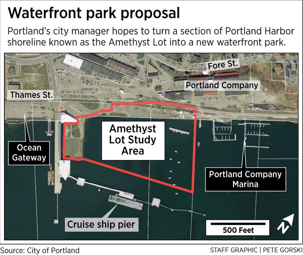
The patch of land and water is between the Ocean Gateway terminal and the former Portland Co. complex, which is being redeveloped into a neighborhood of more than 500 residential units, a marina, offices, retail and restaurants.
The city-owned property was once the site of the Grand Trunk Railway’s grain elevators and wharves. The wharf pilings are still there.
The area consists of about 2 acres of dry land, although only 1.5 acres is unencumbered by trail or rail easements, said Bill Needelman, the city’s waterfront coordinator. The city also is considering uses for about 10 acres of submerged land, 2 acres of which is occupied by the former pier pilings, he said.
The plot has been informally called the Amethyst lot since Cianbro Corp. used it to finish construction of two large offshore oil drilling rigs. The rigs, called Amethyst 4 and Amethyst 5, each weighed 12,000 tons, had topsides that were nearly as long as football fields, and when finished stood 285 feet above the water.
Since the project was completed in 2004, the lot has largely been vacant, other than as a place for people to park their cars and eat lunch or take in the view. Its future has long been discussed in the city.
With condominium projects being built in the India Street neighborhood and the proposed redevelopment of the Portland Co. complex at 58 Fore St., it is time to move the discussion forward, city officials say. In addition, the council’s Economic Development Committee is looking at the entire eastern waterfront, including the Maine State Pier and surrounding roads.
“This is a really exciting opportunity to reuse open space on the waterfront and make it more accessible to the public,” Brenerman said.
According to an Aug. 15 memo to the committee, at minimum the development would include a public boat landing and boat berths, open space and public trail enhancements for cyclists and pedestrians, and space for community boating and Sail Maine, a nonprofit program that provides sailing lessons. It also would enhance public views of the water using low-scale structures.
Other potential developments could include commercial vessel berthing, public restrooms, public fishing and public art.
The staff memo also includes a list of potential features that staffers believe would help achieve the goals. Those features include a tide-pool playground, fountain, play areas, new piers, floating docks and structures, pathways, and lawns and hills, among others. It also refers to “living shoreline/beach constructions.”
City staff has been working with a group of stakeholders that includes the Parks Commission, Planning Board, Portland Trails, Sail Maine, the Portland Society for Architecture, and the Portland Co. developers, CPB2. District 1 Councilor Belinda Ray, the Maine Narrow Gauge Railroad and the Maine Department of Transportation are also being consulted.
“There will also be a public forum later in the process,” Needelman said. “In the interim, we will go to any interested neighborhood group that would like an update on the process.”
A proposed timeline for the project indicates the city would seek a consultant this fall and begin the design process by the end of the year. A public forum would be held in February, after some design alternatives are drafted. A single design could be chosen by March, with a public hearing before the full council next June or July.
Once a plan is drafted and ratified by the council, a funding source and timeline for the upgrades would be determined.
Copy the Story Link
Send questions/comments to the editors.

Success. Please wait for the page to reload. If the page does not reload within 5 seconds, please refresh the page.
Enter your email and password to access comments.
Hi, to comment on stories you must . This profile is in addition to your subscription and website login.
Already have a commenting profile? .
Invalid username/password.
Please check your email to confirm and complete your registration.
Only subscribers are eligible to post comments. Please subscribe or login first for digital access. Here’s why.
Use the form below to reset your password. When you've submitted your account email, we will send an email with a reset code.