

Gulf Hagas is one of those destinations that was on my “to-do” list for a long time, but the opportunity to visit never seemed to come up.
Despite rave reviews from fellow hikers, I always had excuses to stay away: too far, too remote, not on the Maine or New Hampshire 4,000-footer lists. In early October, however, I had the opportunity to visit one of the Appalachian Mountain Club’s remote cabins east of Greenville, and I knew I had to visit “The Grand Canyon of the East” while I was there.
Nestled in 100 Mile Wilderness – what Bill Bryson called “the wildest part of the Appalachian Trail” – Gulf Hagas is a bit of a drive from almost anywhere, requiring many miles on dirt roads without a whiff of cellphone signal to be found. The closest towns are Greenville to the west (by way of Pleasant Street); and Milo, Brownville and Millinocket to the east (by way of Route 11 and Katahdin Iron Works Road). Approaching from the east brings you past the Katahdin Iron Works State Historic Site, where the skeletons of a blast furnace and “beehive” charcoal kiln are all that remain of the 19th-century iron works. From either direction, a fee is charged from May to October.
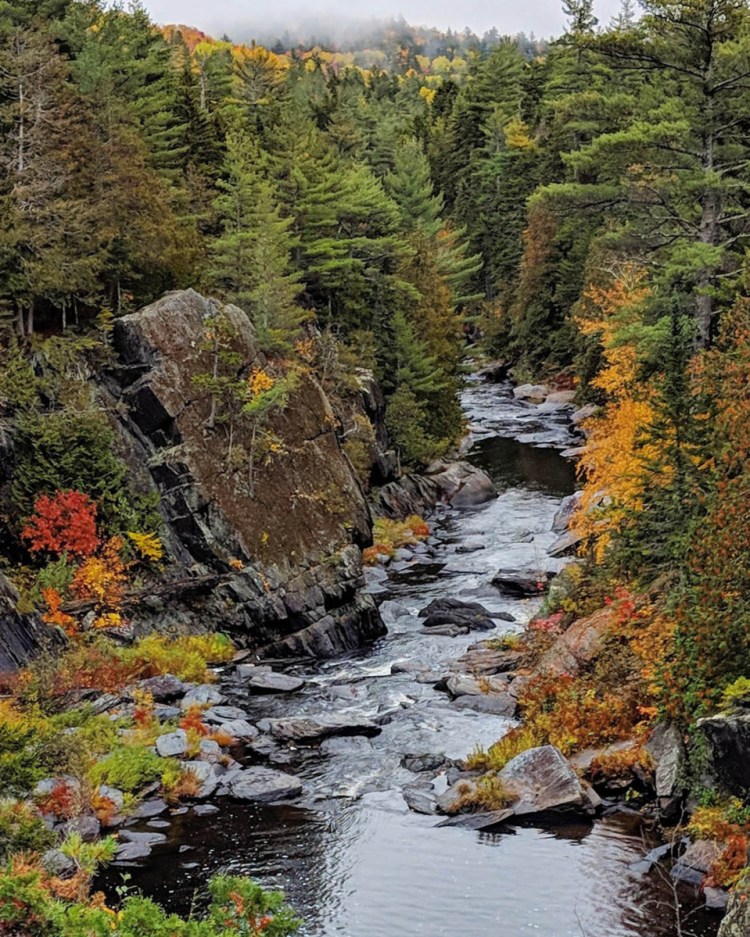
Buttermilk Falls in Gulf Hagas. Photo by Jake Christie
There are two trailheads to access Gulf Hagas, each down miles of bumpy dirt roads: the eastern Gulf Hagas parking area, and the western Upper Gulf parking area. I hiked from the western trailhead for two reasons: it’s closer to the AMC Little Lyford Camp, where I was staying; and it doesn’t require a ford of the Pleasant River, which is part of the eastern approach. Whichever way you hike Gulf Hagas, the trail is about nine miles out and back, or half if you spot a car at each trailhead.
From the west, the wide Lodge to Lodge Trail travels gently over grassy floodplains for a half-mile, then a hard right turn brings you across the Pleasant River on a wooden logging bridge. A short walk up the logging road leads to the true beginning of the Head of the Gulf Trail, well-marked on the right. The trail passes under spruce and northern hardwoods, rambling along easily not far from the eastern banks of the Pleasant River. After about a third of a mile, it passes close to small Lloyd Pond, and an unmarked spur trail leads to the remote fishing spot. Unless you’ve brought your pole and license, stay on the main trail, which continues over a brook crossing and enters National Park Service land.
At a large trail junction, the Rim Trail takes a sharp right turn and descends rapidly toward the Head of the Gulf. Upon reaching the Pleasant River at the western end of the gorge, you may feel as though the majesty of Gulf Hagas has been exaggerated; there are some very pretty rapids and cascades, and a wide, glassy stretch of deeper water, but nothing spectacular.
Rest assured, these headwaters are just a taste of what lies before you. Now that you’re on the rim of the gorge, the fun really begins.
A word of warning: Make sure you’re wearing sturdy footwear and exercise extreme caution on the Rim Trail, especially in slippery conditions. While this trail doesn’t have the elevation changes of a mountain hike, it’s still quite rugged, and the incredible views come with the price of being quite close to the edge of the gorge, often on rocky terrain.
The Rim Trail follows Gulf Hagas for about three miles, with the gorge becoming deeper and deeper, and the falls becoming more and more spectacular. The trail rises and falls with the rim, sometimes offering expansive views from high above the water, and sometimes getting close enough for you to step onto rocks in the river. Here is where the scale of Gulf Hagas becomes apparent; at its deepest point the walls of the gorge are more than 100 feet high.
The views of Billings Falls, which is along the Rim Trail, include a giant gush of water that roils over tall cliffs in the upper half of Gulf Hagas. You’ll also see two other waterfalls on the trail: Stair Falls and Buttermilk Falls.
Traversing from the west, you’ll pass a number of notable and distinctive attractions. In the upper half of the Gulf, you’ll encounter Stair Falls, which resembles the steps of a giant staircase; Billings Falls, where a giant gush of water roils over tall cliffs; and Buttermilk Falls, where a wide, frothy falls resembles buttermilk.
If you’ve had enough hiking for one day, a cutoff trail here can loop you back to the trailhead, cutting your trip in half.
In the lower half of the Gulf, you’ll pass The Jaws, where the upper walls of the gorge narrow look like a set of teeth; Hammond Street Pitch, the deepest section of Gulf Hagas; and finally, three beautiful falls on Gulf Hagas Brook, including the stunning Screw Auger Falls. Past these falls, the eastern end of the Rim Trail concludes at a junction with the Appalachian Trail and the Pleasant River Tote Trail, where a plaque marks Gulf Hagas as part of the National Natural Scenic Register. The Pleasant River Tote Trail is a wide, gently rolling old road that will take you back to the Head of the Gulf trail and the trailhead beyond.
Depending on your route, the hike along Gulf Hagas and back is close to 10 miles, and I can’t recommend better post-hike accommodations than the nearby AMC lodges and cabins: Gorman Chairback, Little Lyford and (farther to the north) Medawisla.
Every AMC destination I’ve been to has welcomed all visitors with kind company, good conversation, a warm fire and wonderful homemade food.
Jake Christie is a freelance writer living in Portland. Along with his brother, Josh, he writes about great Maine destinations for outdoors enthusiasts. Jake can be reached at:
jakechristie@gmail.com
Send questions/comments to the editors.

Success. Please wait for the page to reload. If the page does not reload within 5 seconds, please refresh the page.
Enter your email and password to access comments.
Hi, to comment on stories you must . This profile is in addition to your subscription and website login.
Already have a commenting profile? .
Invalid username/password.
Please check your email to confirm and complete your registration.
Only subscribers are eligible to post comments. Please subscribe or login first for digital access. Here’s why.
Use the form below to reset your password. When you've submitted your account email, we will send an email with a reset code.