

Often, in my quest to explore new hikes and destinations in Maine, I neglect to write about my tried-and-true favorites. There’s no better example of this than the peaks in Camden Hills State Park (CHSP), favorites of mine since I was growing up in the nearby town of Washington. Despite climbing Mount Battie, Mount Megunticook, and other peaks in the park dozens of time in my life, I’ve never before written about them here.
If you’re looking to conquer peaks in CHSP (insofar as sub-1,500-foot mountains are peaks), your two targets are Mount Battie and Mount Megunticook. Battie is the smaller of the two, topping out at just under 800 feet. You’ve got two possible direct routes up from Camden: a shorter, pitchier approach from near Route 52 in town, or a more gradual hike from the parking area near the entrance to the state park.
For the Mount Battie Trail, a trailhead and parking area at the end of Megunticook Street Extension in Camden provides park access. A steep rise through about a quarter-mile of woods, across ledges and scrambles, leads to the expanse of open stone below Battie’s summit. From here, it’s another half-mile of relatively flat terrain to reach the stone tower at the summit.
For the longer-yet-easier hike, the Nature Trail leaves from the camping area off Route 1 at the base of the auto road. The trail ambles along Battie’s eastern slope on a well-trod path through old-growth forest, with a great survey of the flora and fauna of the area – hence the name. A bit shy of a mile, the trail ends at an intersection with the Tablelands Trail, which runs between the peaks of Battie and Megunticook. A turn to the left shortly crosses the auto road that winds up the mountain, and a further half-mile of trail leads to the summit.
A viewfinder offers a postcard-perfect view of Camden Harbor. Photo by Josh Christie
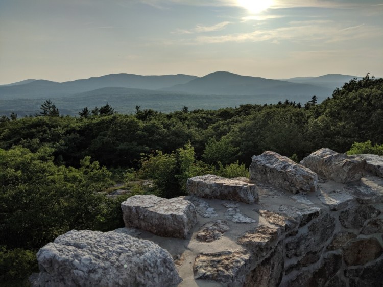
From the top of Mount Battie, hikers are treated to one of the best views on the coast of Maine. To the southeast, picture-perfect downtown Camden sits in front of the harbor, with Curtis Island in the middle distance and North Haven and Vinalhaven further out. Directly south, Rockport and Rockland are visible beyond Camden’s border. A northern exposure offers a view up the coast to Lincolnville and Islesboro. Helpful signs describe the landscape for the curious, and a handful of old school coin-operated viewfinders are available for magnification.
All trails at the state park seem to lead to Ocean Lookout, a dramatic southerly view just shy of the Mount Megunticook summit. The most direct is the Megunticook Trail, which leaves from a trailhead in the state park campground and cuts a fairly straight path up the peak’s southeastern side. Climbing from near sea level to 1,000 feet in the space of a mile, the trail starts fairly steep and gets steeper as you near the summit. Near the top of these pitches, a spur trail (Adam’s Lookout) leaves to the left, promising scenic views below the lookout and summit. Both trails reach the dramatic Ocean Lookout at a bit over a mile from the trailhead, and a further half-mile of hiking along the Ridge Trail reaches the summit proper.
Another option (and one with a more moderate grade) is the aforementioned Tablelands Trail, which connects the summits of Battie and Megunticook. It’s about a mile from the intersection with the Nature Trail to Ocean Lookout, or 2 miles to cover the spread from the peak of Battie to the summit of Megunticook. While it’s an easier trail than the direct route, it’s no cakewalk – expect a fairly strenuous climb between plateaus during the final approach to the Lookout.
Another (favorite) route of mine is the Multi-use and Slope Trails, the latter of which follows the route of an old ski trail on Megunticook. From the camping area near the park entrance, the wide Multi-use Trail covers nearly 2 miles of flat, graveled terrain. At the ski shelter – a structure originally built in the 1930s as a shelter for skiers and rebuilt more recently for campers and parkgoers – a left-hand turn ascends the mile of the old ski slope. It’s a formidable route – as one might expect for a former ski trail, that bypasses Ocean Lookout and ends at the peak.
Trailheads on Youngtown Road and Turnpike Drive, which offer access to Maiden Cliff and Cameron Mountain, also connect to the larger CHSP network. Any can be used to reach either Megunticook or Battie, though they’re a much less direct route than the ones mentioned above.
Looking at the stone tower on Mt. Battie’s summit from the Mount Battie Trail. The tower was built in 1921. Photo by Josh Christie
The trail network in Camden Hills State Park is a legacy of the Civilian Conservation Corp, established during the Great Depression to create work projects for the unemployed. Many of the trails, fireplaces and shelters that still exist in the park were built by these workers in the late 1930s, under the direction of the National Park Service. One exception is the 26-foot tall stone tower at the summit of Mt. Battie, which I’ll admit to having mistakenly thought of for years as a CCC endeavour. In fact, the tower was built in 1921 by the Mount Battie Association, a corporation that had developed a clubhouse and social center on the peak in the late 1800s. The Summit House was torn down in 1920, and the tower (designed by Camden resident Parker Morse Cooper) was built the next year to recognize the men and women of Camden who were part of the World War I war effort.
Josh Christie is a freelance writer living in Portland. Along with his brother, Jake, he writes about great Maine destinations for outdoors enthusiasts. Josh can be reached at:
joshua.j.christie@gmail.com
Send questions/comments to the editors.

Comments are no longer available on this story