

A historic Arctic outbreak continues to bring a bone-chilling deep freeze to the central United States, as the coldest air in generations plunges south and is accompanied by snow and ice all the way to the Gulf of Mexico. Some cities will see their lowest temperatures in more than a century as high-impact winter storms roll across the country.
Temperatures about 50 degrees below average occupy an enormous swath of the central United States, stretching from the Rockies to the Mississippi Valley and the Midwest. At least 15 states could see temperatures of minus-10 or colder, while lows near the U.S.-Canada border flirt with minus-40.
More than 50 million people could see temperatures dip below zero during the next several days as the record-setting deep freeze envelops the country.
Meanwhile, Gov. Greg Abbott issued a state disaster declaration for Texas, where every one of the state’s 254 counties was under a winter storm watch, warning or advisory leading up to the approaching storms.
“Extreme impacts” were likely, according to the National Weather Service. Oklahoma Gov. Kevin Stitt declared a weather disaster emergency for his state, as well, with every county under a winter storm warning. The cold is expected to be damaging in these areas, with pipe bursts in homes adding to ice-induced power outages.
The core of the cold was found bleeding south over the Plains on Sunday morning. This air originated in Siberia and crossed the Pole before moving south into North America.
Numerous daily temperature records are falling during this cold snap, and even some all-time records. For example, the temperature in Bottineau, N.D., fell to minus-51 degrees Saturday morning, an all-time record. Bismarck reported a low of minus-28 early Saturday and was sitting at minus-25 to start Sunday morning.
Grand Forks, N.D., hadn’t reported a temperature above zero since Feb. 6 and probably won’t until at least Monday afternoon. Saturday’s high temperature was minus-12, up from a morning low of minus-27.
Minneapolis had dropped below minus-10 degrees seven of the past nine nights, with Sunday’s low falling to minus-17. Subzero readings had also been observed in Omaha, Des Moines and Chicago, while International Falls, Minn., set a daily record early Saturday at minus-42 degrees.
Wind chill warnings and advisories are in effect from Nebraska to Illinois and northwest to Montana and the Dakotas, indicating the risk of frostbite from the combination of cold air and winds.
The climax of the cold air outbreak is expected Monday night, when temperatures between minus-10 and minus-15 could pour as far south as the Texas Panhandle, with single digits and teens making it to the Gulf of Mexico. Houston could start early Tuesday at 10 degrees, which would be its coldest reading since 1989.
Oklahoma City may hit minus-11 on Tuesday morning, a temperature not observed there in 116 years. In Texas, the electrical grid was under strain because of heavy demand from the impending cold.
The cold air’s push south is associated with a deep dip in the jet stream, a narrow river of strong upper-level winds slicing across the country. A steep temperature contrast between the frigid air and relatively mild air to the south and east will spark winter storms that are poised to bring a rare dose of prolonged winter weather to tens of millions.
Depending on its effect on agriculture and the broader economy, this cold snap could end up on the list of 2021′s billion-dollar weather events because of its wide scope, duration and severity.
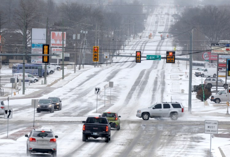
Snow had already broken out in the Texas Panhandle and much of Oklahoma early Sunday, with moderate snow reported in Amarillo, Texas, and Tulsa. In Albuquerque, a severe thunderstorm warning was issued for a lightning-producing snow squall as the developing system got underway Saturday night.
The dangers of the winter weather was highlighted on Thursday in Fort Worth, when at least six people were killed during the morning in a 133-car pileup on icy roads slickened by freezing drizzle. Now, the Metroplex is bracing for a plowable snowfall of 3 to 4 inches, which will again lead to hazardous driving conditions.
Snow will increase in coverage and intensity across the Lone Star State and Oklahoma throughout the day on Sunday, with heavy snow possible at times with an isolated rumble of thunder. Five to 10 inches of snow was expected in Oklahoma City, where single-digit temperatures dropping below zero Sunday night were expected to lead to a fluffy powder and winds were forecast to lead to blizzard conditions at times.
There was a chance that Austin could see more snow from the system than the 4.5 inches Washington, D.C., has measured this winter.
In Texas, freezing rain and sleet could make it to such places as Brownsville and Corpus Christi, even dipping into Tamaulipas, Mexico. Winter storm warnings were up for every county in Texas. Houston was expecting 1 to 2 inches of snow, along with a 10th to a quarter of an inch of ice.
For the first time, the National Weather Service issued a wind chill warning that covers Houston. The warning, in effect from Sunday night through noon local time on Tuesday, calls for wind chills to potentially drop below zero.
More snow is forecast to pile up north of the city, where up to 6 inches could fall in College Station, followed by a steep drop in temperatures with wind chills heading below zero.
“Prepare for power outages and have nonperishable food and water on hand,” wrote the National Weather Service in Houston. “Do not travel unless it is an emergency.”
Sleet and freezing rain were likely across most of Louisiana except for the Florida Parishes and greater New Orleans, with a dangerous glaze of 0.1 to 0.3 inches of ice likely in Lake Charles, a region ravaged by back-to-back hurricanes during August and October 2020.
The storm will pull northeast on Monday, affecting such places as Memphis, Louisville and Cincinnati with snow and Jackson, Miss., Nashville and Lexington, Ky., with freezing rain and ice.
Ice storm warnings are also up in Charleston, W.Va., where up to a quarter-inch of ice is expected. This could cause outages as trees take out power lines.
Thereafter, significant snow accumulations are expected in the Northeast and interior New England, with a messy mix for some and rain near the coast. On the warm side of the storm, flooding and severe weather could occur Monday and Tuesday in parts of the southeastern United States and Florida.
There is a growing chance that yet another winter storm laden with snow and ice could spin up from the Southern Plains through the Mississippi and Tennessee valleys on Wednesday and Thursday, again pulling into the Northeast.
The barrage of storminess and extreme cold can be traced back to an early January disruption of the polar vortex, which allowed lobes of extreme cold to ebb south over North America, Europe and Asia. A weaker polar vortex has a tougher time bottling up Arctic air at high latitudes, allowing for cold air outbreaks in areas where we reside.
The cold pattern looks to ease late in the week, along with a moderation in temperatures and, perhaps, a slight quieting of the weather pattern currently affecting the country.
Send questions/comments to the editors.

Success. Please wait for the page to reload. If the page does not reload within 5 seconds, please refresh the page.
Enter your email and password to access comments.
Hi, to comment on stories you must . This profile is in addition to your subscription and website login.
Already have a commenting profile? .
Invalid username/password.
Please check your email to confirm and complete your registration.
Only subscribers are eligible to post comments. Please subscribe or login first for digital access. Here’s why.
Use the form below to reset your password. When you've submitted your account email, we will send an email with a reset code.