


Hurricane Ida is growing in size and power as it moves north across the Gulf of Mexico toward Louisiana, and New Orleans is bracing for disaster – clearing out hospital wards, shutting down oil refineries and forcing residents of low-lying neighborhoods to flee.
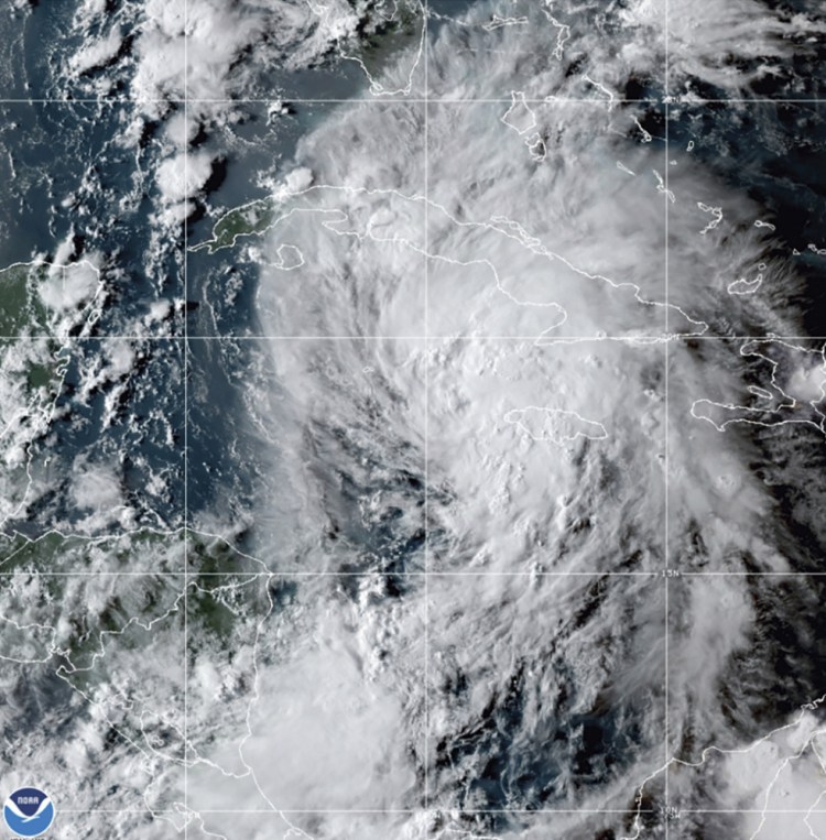
Ida slammed into Cuba on Friday night and is moving north toward the U.S. Gulf Coast with winds that are expected to hit 130 miles per hour, and a wall of water that may reach 15 feet in height.
The storm was about 290 miles south of the Mississippi River with winds of 100 mph, up from 85 mph earlier, the National Hurricane Center said in an advisory at 2 p.m. local time. It’s expected to make landfall Sunday night or early Monday morning.
“We are beginning to see the rapid intensification of the storm,” Deanne Criswell, administrator of the Federal Emergency Management Agency, said at a briefing at the White House.
The city of New Orleans is asking residents to evacuate as soon as possible or prepare to shelter in place, according to a text alert sent late Friday. The mass transit system will be suspended at 6 p.m. Saturday, and the levee gates will close at 8 p.m. in many areas. The storm could damage close to 1 million homes along the coast, with potential reconstruction costs estimated to exceed $220 billion, according to CoreLogic.
With winds strong enough to destroy dwellings and knock out power for weeks or longer, areas that suffer a direct hit could be uninhabitable for weeks or months, according to the hurricane center.
“This is kind of an alarming situation,” said Jim Rouiller, lead meteorologist at the Energy Weather Group. “It could be catastrophic.”
There’s little in Ida’s way to stop it from ramping up to the second-most destructive category of storm given the deep eddy of 86 degrees Fahrenheit sea water that it will traverse before it roars ashore, said Todd Crawford, director of meteorology at commercial forecaster Atmospheric G2. Warm water is like fuel to tropical cyclones.
The storm’s winds haven’t been strengthening as rapidly as forecast Friday, but it’s showing signs it could grow in size soon, the hurricane center said. While the winds may not reach the earlier maximum of 140 mph, it will still bring a devastating surge to the coastline and drop heavy rain inland. There’s about a 15 percent chance it could grow much stronger and even reach Category 5 strength briefly, Crawford said.
“Everything you need for a hurricane to explode is in place and we are seeing signs of that happening right now,” Rouiller said. “I am alarmed.”
The combination of wind, flooding and tornadoes will lead to widespread destruction and power outages in some places that could last weeks, Rouiller said.
Ida made landfall in the Cuban province of Pinar Del Rio shortly before 7:30 p.m. local time, with winds of 80 mph. It’s expected to hit New Orleans on the 16th anniversary of Hurricane Katrina, one of the most devastating natural disasters in U.S. history.
More than 200 flights to and from Louis Armstrong International Airport have been scrubbed for Sunday, according to FlightAware, an airline tracking service. The airport was thronged with local residents lining up for outbound flights or trying to rent vehicles to flee the city. Queues at rental car kiosks were two hours long.
Oil and gas prices gained Friday as energy companies shuttered facilities and evacuated workers. Louisiana Children’s Medical Center is sending home some patients and will put its six New Orleans-area hospitals into lockdown Sunday morning. On its current track, the storm could cause from $10 billion to $30 billion in damage and losses, said Chuck Watson, a disaster modeler with Enki Research.
“Little wobbles matter a lot,” Watson said. “If it goes just east of New Orleans, that risks pumping water into Pontchartain and overtopping the levees and all bets are off.”
Some levees outside of the Hurricane and Storm Damage Risk Reduction System could be topped by the waters. About half of all hurricane deaths are due to flooding.
President Biden declared a state of emergency for Louisiana. New Orleans, often referred to as NOLA, is below sea level and depends on levees and pumps to keep the ocean and river out. The Mississippi River in downtown New Orleans is forecast to rise by more than 6 feet Sunday, the National Weather Service said.
“NOLA is always a place that things can go wrong quickly and badly,” said Enki Research’s Watson.
Even if the levee system holds and keeps the surge at bay, New Orleans could face a major flood risk from the rain alone, said Ryan Truchelut, president of Weather Tiger LCC. FEMA has deployed about 2,500 people to Louisiana and states including Alabama, Florida, Georgia, Mississippi and Texas. Urban Search and Rescue teams are being sent to Louisiana, it added, with other teams on alert.
Oil explorers are bracing for the storm and have already halted the equivalent of more than 1.2 million barrels of daily crude production. Royal Dutch Shell Plc, BP Plc and others are shutting offshore platforms and evacuating crews.
The Gulf is home to 16 percent of U.S. crude production, 2 percent of its natural gas output, and 48 percent of the nation’s refining capacity. After Ida comes ashore, it could also flood cotton, corn, soybean and sugarcane crops, said Don Keeney, a meteorologist with commercial forecaster Maxar.
Send questions/comments to the editors.

Success. Please wait for the page to reload. If the page does not reload within 5 seconds, please refresh the page.
Enter your email and password to access comments.
Hi, to comment on stories you must . This profile is in addition to your subscription and website login.
Already have a commenting profile? .
Invalid username/password.
Please check your email to confirm and complete your registration.
Only subscribers are eligible to post comments. Please subscribe or login first for digital access. Here’s why.
Use the form below to reset your password. When you've submitted your account email, we will send an email with a reset code.