


Time lapse courtesy of Greater Portland Council of Governments.
A washed-out access road to a popular tidal sandbar on Chebeague Island is giving coastal residents a glimpse of what is to come in a warmer Gulf of Maine, where sea levels are rising and more frequent and severe storms boost the size of waves hitting the coast.
Chebeague sits about 10 miles northeast of Portland and has a year-round population of about 500 people. The loss of a third of the gravel road leading out to The Hook doesn’t hurt anyone. It doesn’t cut off a school, fire station or private home. It won’t keep hikers from a low-tide path to a popular picnicking area.
But it serves as a reminder that the impacts of climate change mean the next road washout could be much worse. That is why the Greater Portland Council of Governments is working with area communities to monitor coastal erosion around Casco Bay.
“The changes at The Hook have been very dramatic,” said Pete Slovinsky, a marine geologist with the Maine Geological Survey. “The center portion of the beach has eroded 10 to 15 feet over just three years. It’s a dynamic system, so it’s meant to move, but that’s a lot.”
The change is clearly visible through aerial photography shot by GPCOG planner Rick Harbison, who is also monitoring coastal sites in Brunswick, Yarmouth, Falmouth and Scarborough. But Harbison said The Hook, a 25-acre intertidal nature preserve, has changed most of all.
Slovinsky attributes that movement to the intense wave energy from two intense winter storms, one in 2018 and one in December 2022, on top of already rising seas. They both scoured the central sandy beach, moving much of the sand over to The Hook’s elbow. The last storm took out the road.
People can still park their cars and walk to the quarter-mile-long sand bar that at low tide connects the public area of The Hook to Little Chebeague Island, an uninhabited 100-acre island known for its flat trails and jaw-dropping views across the bay of Portland and Falmouth.
The owners, Indian Island Company, probably won’t replace the private road. It would cost a lot, and they couldn’t tap into government funding to help pay for it because The Hook is a coastal barrier resource area, which is, by definition, meant to be left alone.
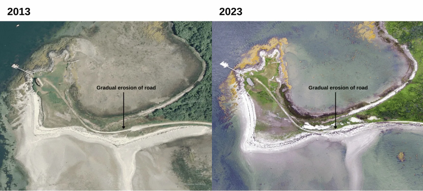
A side-by-side comparison showing the erosion of The Hook on Chebeague Island in 2013, left, and earlier this year. Photos by Rick Harbison/Greater Portland Council of Governments
Erosion has always been a threat at The Hook, which explains why long-ago landowners built a bulkhead along part of the road. But that kind of heavy armored approach to erosion control isn’t encouraged now because it only diverts the wave action to adjacent areas.
To reduce the likelihood of another washout, Slovinsky said the owners would probably have to implement other expensive measures in addition to costly out-of-pocket armoring, like planting kelp beds or building near-shore oyster reefs, but those would provide no long-term guarantees.
There is a century-old private boathouse at the end of The Hook that can no longer be reached by car, which will make its upkeep more complicated. But local property owners like Phyllis Brunner, a longtime summer resident from Seattle, don’t mind walking down a footpath to their boats.
“I think this is one of those times when we must adapt,” Brunner said. “We looked at solutions, costs and the survivability of those solutions during storms. It would cost an exorbitant amount of money to armor it without a guarantee that it would hold out.”
Sea level rise from climate change happens for two reasons, Slovinsky said: As the temperature of the oceans increases, even by a few degrees, it gets bigger and takes up more space, and the accelerating melting of freshwater that had been locked up in ice, glaciers and ice sheets.
Climate change also causes more frequent extreme weather and storm surges. A storm surge on top of already high water levels can be catastrophic, Slovinsky said. Portland’s water levels were 8 inches higher than the long-term average in June and July, the highest ever recorded.
The state’s climate action plan projects will range from 1½ to 3 feet by 2050, depending on the world’s success in curbing greenhouse gas emissions. It will affect Maine’s entire coast and cause the loss of 40% to 75% of Maine’s dry beach area. Over time, much of The Hook will be underwater.
Because the projected 2050 sea level rise would hit Maine’s sandy beaches hard, it would hurt tourism, potentially resulting in the loss of more than a million yearly visitors and $136 million in annual tourism revenue, according to Maine Climate Council projections.
Brunner believes Chebeague had more important places to protect from sea level rise.
She singled out Stone Wharf, a municipal wharf on the island’s northwest side where the Chebeague Transportation Company’s ferry, the Independence, docks. It carries 10,000 people a month to and from Yarmouth. It is overtopped by high tides and storm surges at least once a year.
Chebeague is using a $50,000 state community resilience partnership grant to continue studying how to prepare the wharf for rising sea levels and more frequent storm surges, in addition to funding a groundwater sustainability study, a greenhouse gas inventory and a climate action team.
“Climate change is front and center on Chebeague because people can see it for themselves, at the beaches, at the ferry landing, on the water,” Brunner said. “I used to go fishing, and I could catch 30 mackerel in 30 minutes. Our waters would be cold and crispy all summer. Those days are long gone.”
As an environmental engineer, Brunner was shocked when she saw the wind and waves of December’s storm had gouged out a foot and a half of the base of the access road. She doesn’t know how high the waves got that night. They reached 21 feet at nearby Mackworth Island.
But The Hook washout does have a silver lining, Brunner said. With reduced traffic, the beach is restoring itself, its dune grasses are healthier than she has ever seen them before and, perhaps most importantly, it has become home to several pairs of piping plovers.
These small, sand-colored birds known for their plaintive whistle built at least four nests in the sand at The Hook, each one started by the male and finished by the female. Once common in southern Maine, piping plovers are listed as endangered under the Maine Endangered Species Act.
Copy the Story LinkSend questions/comments to the editors.

Success. Please wait for the page to reload. If the page does not reload within 5 seconds, please refresh the page.
Enter your email and password to access comments.
Hi, to comment on stories you must . This profile is in addition to your subscription and website login.
Already have a commenting profile? .
Invalid username/password.
Please check your email to confirm and complete your registration.
Only subscribers are eligible to post comments. Please subscribe or login first for digital access. Here’s why.
Use the form below to reset your password. When you've submitted your account email, we will send an email with a reset code.