

A kayaker passed the rugged shore of Rutherford Island. Ron Chase photos
One of the most interesting and less well-known sea kayak destinations on the Maine coast is Thrumcap Island. Located between outer Johns Bay and the mouth of the Damariscotta River, the diminutive atoll is the last stop after passing a series of rugged ledges with the unique name Thread of Life.
The Thrumcap area has some of the richest history in America. Prior to the arrival of European explorers and settlers, Native Americans lived in settlements on the shore of Johns Bay and along the Damariscotta River for centuries where they traveled the waterways in primitive canoes. Explorers such as John Smith and Giovanni da Verrazzano visited the area in the 16th and early 17th centuries. In 1688, a fort was built on nearby Pemaquid Neck during the French and Indian Wars, a conflict that continued for decades.
When I recently announced a Penobscot Paddle & Chowder Society sea kayak trip to Thrumcap Island, two longtime friends, Dave Boyle and Ken Gordon, enthusiastically signed on. All over 70, we constituted a serious senior threesome.
The sometimes treacherous Thread of Life ledges are explored.
In the past, I’ve started my Thrumcap trips from the boat landing at Colonial Pemaquid State Historic Site at the mouth of the Pemaquid River. Dave suggested a relatively new launch area more conveniently situated at The Gut in South Bristol.
The three of us met at the small landing on the east side of the bridge over The Gut. We were greeted with a glorious warm sunny day with light winds. A paved ramp and adequate parking make this an ideal place to begin and end a sea kayak voyage to Thrumcap.
Paddling three solo kayaks, we benefited from an outgoing tide when embarking into The Gut. The sheltered channel was frequently used as a safe passage by Native Americans many generations ago. Today, the tiny harbor is bustling with activity. Fishing vessels and pleasure crafts were motoring to and from their moorings when we exited traveling east.
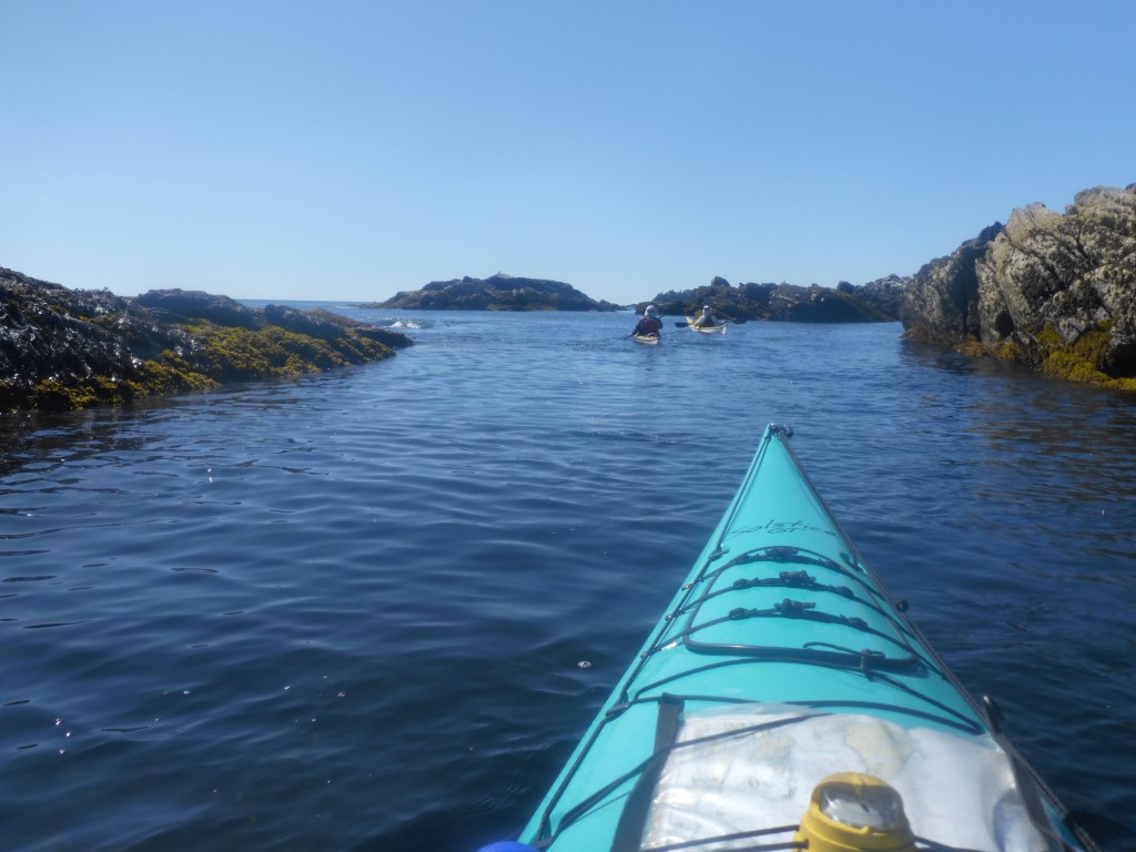
The waterway widened as we kayaked between Witch Island and Davis Point into Johns Bay. Restored Fort William Henry was visible in the distance on Pemaquid Neck. Angling south, we progressed past the rugged eastern shoreline of Rutherford Island with Johns Island in the center of the bay on our left.
Proceeding south, we arrived at the northern end of Birch Island which parallels and hugs the eastern shore of Rutherford Island. Almost low tide, we speculated about the feasibility of traversing through the attenuated route between the islands. Our nautical charts were unclear. We gambled and won as we were just barely able to negotiate between some ancient pilings, under a bridge and through the narrow corridor.
After passing Hay and Crow Islands on our left, we entered the Thread of Life ledges, which begin opposite the southern terminus of Rutherford Island. Since the seas were calm and winds light, the sometimes-treacherous ledges provided a stimulating opportunity for exploration.
A paddler finds a route through ancient pilings on the inside of Birch Island.
Shortly beyond Thread of Life, we arrived at Thrumcap Island. A small beach on the southern arm of the island offers a convenient place to land. After carrying our kayaks high onto the beach to protect against the rising tide, we hiked an irregular path to the scenic rockbound shore on the south side of the island.
When leaving Thrumcap and departing north, an incoming tide and a gentle tailwind helped propel us between Inner Heron and Rutherford Islands into outer Damariscotta River. We soon passed Christmas Cove on the western side of Rutherford Island. The cove was reportedly named by explorer John Smith when he moored there on Christmas Day in 1614. Some sources dispute that.
Cruising blithely along with the assistance of the wind and tide, we accidentally passed the entrance to The Gut and continued north on Damariscotta River. Unfamiliar surroundings indicated there was a problem. Ken’s GPS confirmed we had missed our destination. Backtracking to The Gut was necessary. A marvelous day, we embraced the “free mileage.”
The bridge connecting South Bristol to Rutherford Island was raised for tall boat traffic when we entered The Gut. After the congestion abated, we rode a strong current through the narrow opening completing a phenomenal day of kayaking.
My book, “Maine Al Fresco: The Fifty Finest Outdoor Adventures in Maine,” relates eight more exciting Maine sea kayaking adventures.
Ron Chase resides in Topsham. His latest book, “Maine Al Fresco: The Fifty Finest Outdoor Adventures in Maine” is available at northcountrypress.com/maine-al-fresco or in bookstores and through online retailers. His previous books are “The Great Mars Hill Bank Robbery” and “Mountains for Mortals – New England.” Visit his website at ronchaseoutdoors.com or he can be reached at ronchaseoutdoors@comcast.net.
Copy the Story LinkSend questions/comments to the editors.


Success. Please wait for the page to reload. If the page does not reload within 5 seconds, please refresh the page.
Enter your email and password to access comments.
Hi, to comment on stories you must . This profile is in addition to your subscription and website login.
Already have a commenting profile? .
Invalid username/password.
Please check your email to confirm and complete your registration.
Only subscribers are eligible to post comments. Please subscribe or login first for digital access. Here’s why.
Use the form below to reset your password. When you've submitted your account email, we will send an email with a reset code.