

The boulder-strewn Carrabassett River parallels the Narrow Gauge Pathway in many places. Ron Chase photos
One of the most unique bike trails in Maine is the historic Narrow Gauge Pathway in Carrabassett Valley. The trail follows the former Kingfield and Dead River Railroad bed used to convey logs to a sawmill situated in Bigelow at the northern terminus of the railway in the early 20th century. Disuse resulted in discontinuance of the railroad in 1927. The town of Carrabassett Valley constructed the pathway in 2001.
Serene and scenic describe the bucolic, crushed-stone and dirt-surface trail as it travels next to the boulder-strewn Carrabassett River located in a deep valley situated between Sugarloaf Mountain and the Bigelow Mountain Range. Wide hybrid- or mountain-bike tires are necessary to ensure an enjoyable ride on the unpaved surface. Motorized vehicles including ATVs and snowmobiles are prohibited. The trail is also groomed for cross-country skiing in winter.
My wife, Nancy, and I try to ride the Narrow Gauge each fall and recently planned our annual return. We started our trek at the Airport Trailhead on a cool, breezy, autumn day. Located adjacent to a small airport about a mile north of the Carrabassett Valley Town Office, there is spacious parking and a restroom.
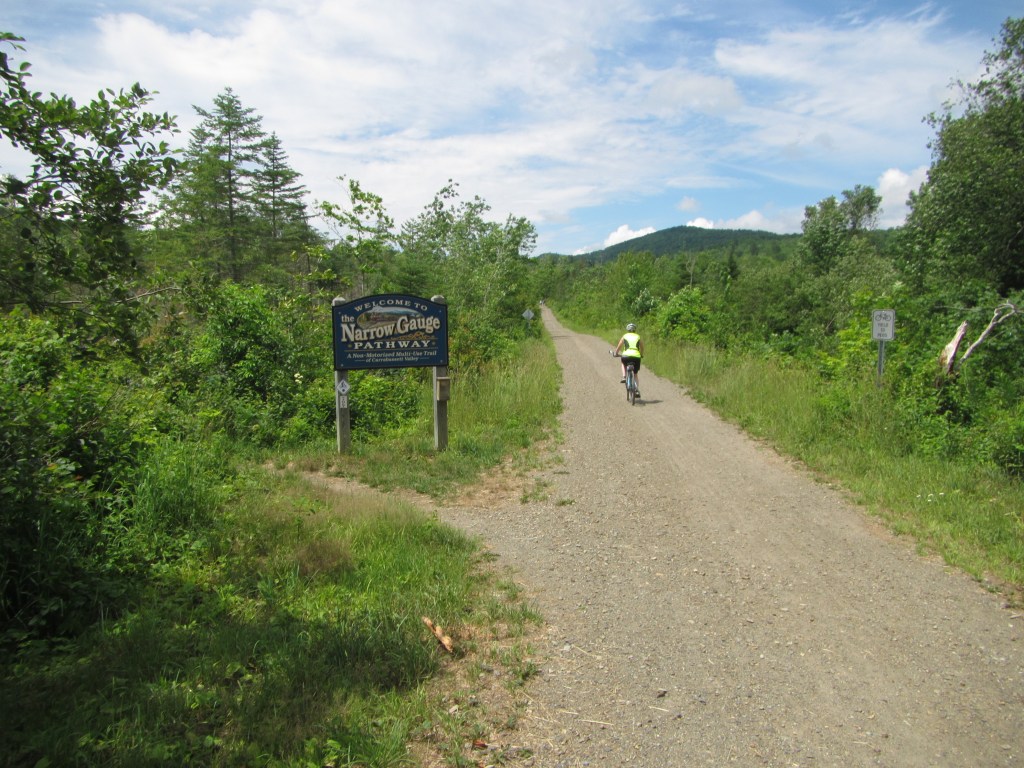
A cyclist begins a ride north on the Narrow Gauge Pathway.
We began the ride on a short, rough, multi-use connector trail that soon traverses the Carrabassett River on a sturdy well-designed bridge to a sign that announces the beginning of the Narrow Gauge Pathway. Immediately crossing a short bridge over Houston Brook, we began climbing gradually in forested terrain. Sheltered from the wind by a canopy of overhanging trees, our ride was comfortable throughout. While never steep, the path rises steadily for much of the remainder of the trek to the northern end in Bigelow.
After leaving the Carrabassett River, we persevered uphill for a short mile past a Maine Huts Trail junction on the right. The path rejoins the mountain freshet overlooking the steepest part of the river. My paddling friends and I refer to the precipitous section of whitewater as Upper Carrabassett. Memories of previous whitewater descents were a distraction as we passed the most difficult rapids called Pinnacle Rock, Don’s Hole, Terry’s Perch and Triple Drop.
River views coupled with lush vegetation in this area provide an exceptionally scenic environment. Picnic tables are scattered strategically along this sector of trail. Most were occupied by cyclists taking a break or enjoying a snack.
Shortly after the last picnic table, the path leaves the river and crosses a long bridge over a wetlands area where we observed a moose feeding close to the path. We lingered to watch the voracious cow moose that seemed unperturbed by our presence.
A moose was observed feeding along the trail on this ride.
We soon passed an ancient cabin on the left where the path briefly reconnects with the river. A hunting and fishing camp built by railroad workers in 1900, the hut is privately owned and still in use. This area was formerly called Crockertown, named for early lumberman Isaac Crocker.
Proceeding westerly, we passed a left turn that leads to Campbell Field Trailhead and another junction on the right that links to Stratton Brook Hut. A sign indicates the hut is 2.2 miles east.
We reached the outskirts of the old village of Bigelow soon after. The tiny community is posted as private property. The former Bigelow Train Depot is situated near Route 27 and is now a private residence.
Angling left, we continued over a bridge and past a side trail on the right that leads to the Stratton Brook Trailhead. Just beyond, the Narrow Gauge Pathway ends at Route 27. The is no parking at this location. On return, we followed the .1-mile spur to Stratton Brook Trailhead. More difficult than the pathway, the approach to the parking area is steep and rocky.
After returning to the Campbell Field turnoff, a brief ride brought us to that alternative trailhead where there is a picnic table, restroom and ample parking. After a lunch break, we cycled back to the Airport Trailhead, completing an exceptional 11.25-mile roundtrip that included the short excursions to the Stratton Brook and Campbell Field Trailheads.
The return is almost all downhill. What a treat for two senior cyclists in a biking paradise!
My book, “Maine Al Fresco: The Fifty Finest Outdoor Adventures in Maine,” narrates exciting rides on four more bike trails and three offshore islands.
Ron Chase resides in Topsham. His latest book, “Maine Al Fresco: The Fifty Finest Outdoor Adventures in Maine” is available at northcountrypress.com/maine-al-fresco or in bookstores and through online retailers. His previous books are “The Great Mars Hill Bank Robbery” and “Mountains for Mortals – New England.” Visit his website at ronchaseoutdoors.com or he can be reached at ronchaseoutdoors@comcast.net.
Copy the Story LinkSend questions/comments to the editors.


Success. Please wait for the page to reload. If the page does not reload within 5 seconds, please refresh the page.
Enter your email and password to access comments.
Hi, to comment on stories you must . This profile is in addition to your subscription and website login.
Already have a commenting profile? .
Invalid username/password.
Please check your email to confirm and complete your registration.
Only subscribers are eligible to post comments. Please subscribe or login first for digital access. Here’s why.
Use the form below to reset your password. When you've submitted your account email, we will send an email with a reset code.