

A sign implanted in a cairn marks the summit of Pleasant Mountain. Ron Chase photos
Stormy weather negatively impacted our plans for a western Maine mountain hike. My son, Adam, and I intended to climb lofty Number 5 Mountain in a remote wilderness area southwest of Jackman.
When we met in West Forks on a gray, foggy morning with a threat of light rain or snow showers, several inches of new snow had fallen. To reach Number 5 Trailhead required motoring slick dirt roads for about 20 miles, the last section likely unplowed. Number 5 was written off.
Instead, we decided to attempt Williams Mountain — another excellent peak positioned southeast of Jackman with better road access than Number 5. Most of the drive was on plowed, paved roads. However, when we arrived at the rough, unpaved Williams Mountain Road, problems were encountered. Although the road was previously plowed, additional snow had accumulated. An icy undercoat made it unsafe to navigate. A search for another mountain hike ensued.
After studying our Maine atlas while parked at the snow-filled entrance to Williams Mountain Road, we decided to climb Pleasant Mountain. Our choice was the “other” Pleasant Mountain situated east of the village of Caratunk as opposed to the very popular Pleasant Mountain hike in the southwestern part of the state.
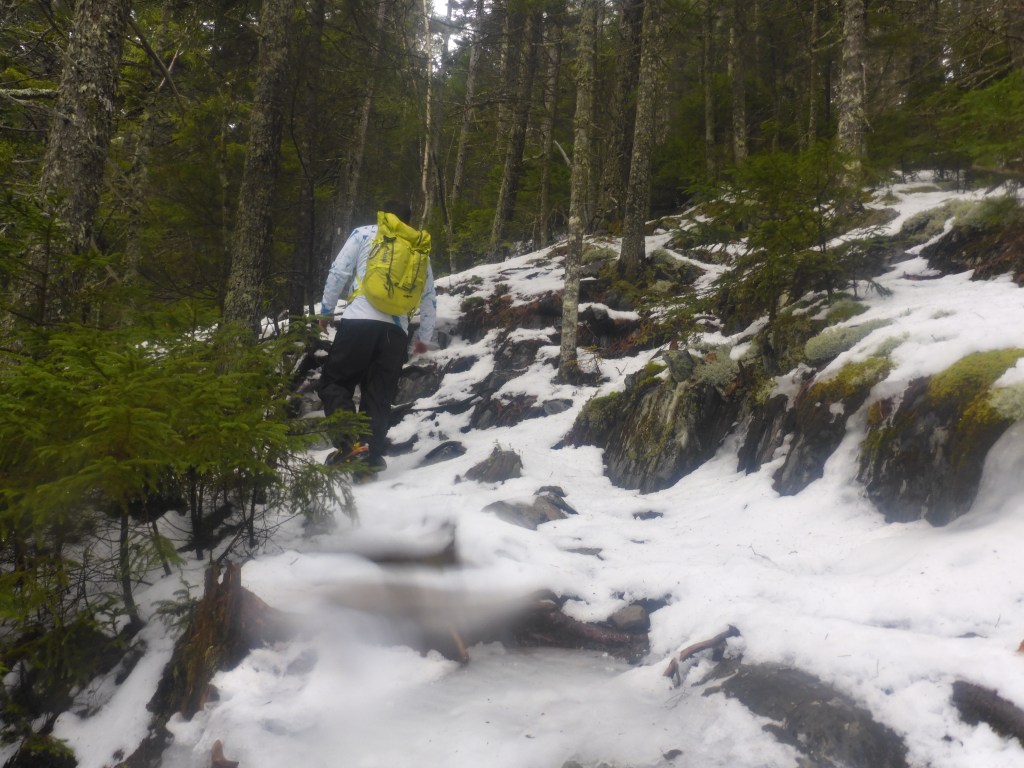
Much of the trail was snow and ice covered.
Located about 10 miles south of West Forks, hiking access to Pleasant Mountain is via the Appalachian Trail. From Route 201, we drove through Caratunk on Pleasant Pond and North Shore roads to an intersection a short distance from the AT. The last portion of North Shore Road was icy but manageable.
We hiked down the ice and snow-covered access road to a sign for the AT. Initially, the trail travels through wet, low-lying terrain. The recent storm left the surface partially covered with ice and snow and very muddy. Although discouraged, we persevered through the moisture-saturated landscape and past side trails to Pleasant Pond and a lean-to.
Our spirits improved when we gained higher, drier ground and progressed steeply upwards on a carpet of snow and ice in a sparse conifer forest. Several weaving precipitous sections required careful maneuvering, and walls of ice on two steep inclines had to be skirted by bushwhacking.
After advancing to the upper reaches of the mountain, the gradient moderated as the trail circles around the north side of the peak. Many years have transpired since either of us has climbed Pleasant Mountain. Neither of us recalled this essentially flat circuitous sector of trail and speculated the path has been rerouted in the interim.
The lengthy, almost level segment of pathway allowed for virtually effortless hiking. Shortly after, the trail angles southeasterly and we began ascending steadily in stunted conifer growth. A massive snow-capped boulder marked a dramatic change in the character of the trail and required careful maneuvering on an icy surface along the less vertical right side. We then scrambled up a steep sloping ledge that appeared to be the mountaintop.
A steep sloping ledge turned out to be a false summit. Ron Chase photo
The rounded barren prominence turned out to be a false summit. Exposed ledges continued in an easterly direction. We hiked easily in a few inches of wet snow through a sparse wooded area and climbed another bald peak to the true summit marked by a sign implanted in a cairn.
Alas, thickening fog concealed what would have been spectacular views. Swirling clouds and fog-enveloped alpine environments have their own special appeal. We embraced the moment. Parkas were donned as we paused to enjoy a late lunch and a much-needed break.
We had completed the climb without using micro-spikes. However, descending on snow and ice is much more hazardous, so we opted to wear them on our return. A good decision, as they permitted traveling down the often slippery trail with confidence and minimal difficulty.
The spikes were removed when we arrived at the low-elevation wetlands. The remainder of our trek was relegated to trudging through a messy mixture of mud, snow and soft ice. However, given the inauspicious beginning to the day, we were consoled by the realization that what began as a lemon had turned into lemonade.
My book, “Maine Al Fresco: The Fifty Finest Outdoor Adventures in Maine,” narrates nine more mountain hikes around the state, including several winter expeditions.
Ron Chase resides in Topsham. His latest book, “Maine Al Fresco: The Fifty Finest Outdoor Adventures in Maine” is available at northcountrypress.com/maine-al-fresco or in bookstores and through online retailers. His previous books are “The Great Mars Hill Bank Robbery” and “Mountains for Mortals — New England.” Visit his website at ronchaseoutdoors.com or he can be reached at ronchaseoutdoors@comcast.net.
Copy the Story LinkSend questions/comments to the editors.


Success. Please wait for the page to reload. If the page does not reload within 5 seconds, please refresh the page.
Enter your email and password to access comments.
Hi, to comment on stories you must . This profile is in addition to your subscription and website login.
Already have a commenting profile? .
Invalid username/password.
Please check your email to confirm and complete your registration.
Only subscribers are eligible to post comments. Please subscribe or login first for digital access. Here’s why.
Use the form below to reset your password. When you've submitted your account email, we will send an email with a reset code.