


Extreme weather made more frequent and ferocious by climate change has walloped Maine in the last year, and the coastal devastation wrought by recent storms is causing many Mainers to realize that climate change is happening right now.
From Kittery to Eastport, climate change came to life. Mainers could do little but watch as storms rushed in on seas elevated by climate change, buckling roads, scouring beaches and washing away our working waterfronts.
“People aren’t just waking up to climate change, but these storms have made theory into a pretty scary reality,” said Hannah Pingree, co-chair of the Maine Climate Council. “People thought we’d have more time to change, to prepare. This was our wake-up call. We’re running out of time.”
Between the two storms that hit the coast on Jan. 10 and 13, and the Dec. 18 storm that wreaked at least $20 million in damage to 10 Maine counties, there’s almost no way a Mainer could have missed the impact of this extreme weather, which can be traced back to climate change.
Over the last century, Maine sea levels have been rising at a rate of about a half-foot a century. The pace has sped up as the world burns more fossil fuels, producing heat-trapping emissions that warm both air and sea. About half of our sea rise over the last century has occurred since the early 1990s.
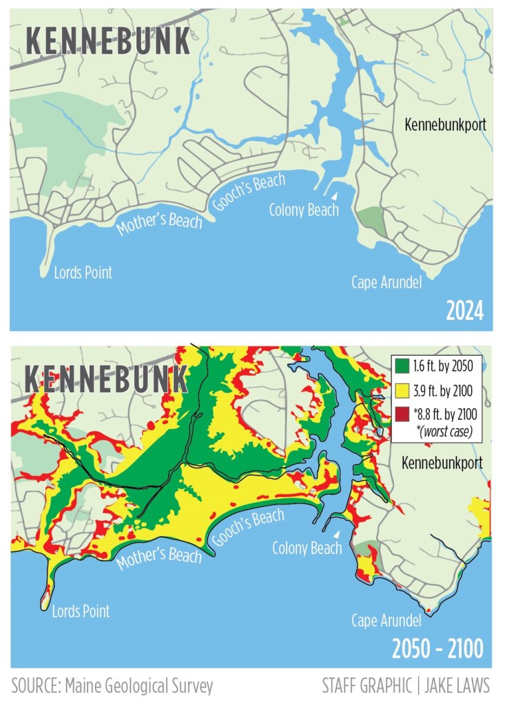
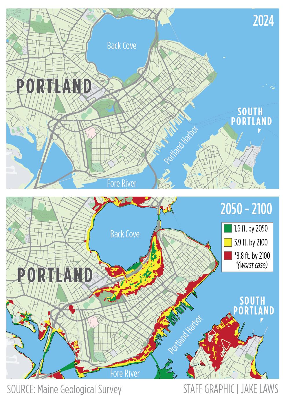
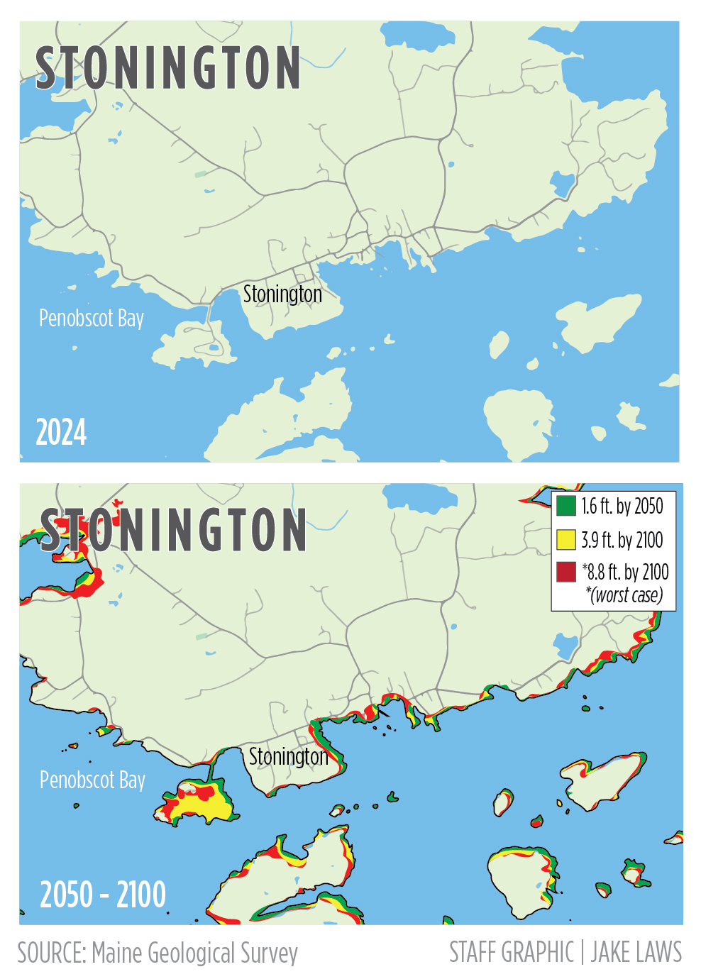
Maine sea levels are projected to rise between 1.1 and 3.2 feet by 2050 and 3 and 9.3 feet by 2100, depending on how successful and quick we are at curbing global emissions rates, according to the scientists who advise the Maine Climate Council.
How does climate change affect sea levels? In a warming world, glaciers and ice sheets are melting, adding water to the ocean. The ocean also expands in volume as the water warms. Ocean circulation patterns, terrestrial water storage and the gravitational effects of glaciers also play a small role.
Gulf of Maine sea levels are projected to rise faster than the global average because it is susceptible to changes in the Gulf Stream and seasonal wind patterns, according to the Island Institute, a Rockland-based nonprofit advocacy and research group that serves Maine’s coastal and island communities.
The council projections are coastwide estimates, but each coastal community has its own rate of sea level rise, controlled largely by geology. Since 1993, Bar Harbor and Portland seas have risen at a rate of just over a foot per century, records show, while Eastport’s seas have risen 1.3 feet.
Mainers don’t have to imagine what storms like the ones we had last week will do to Maine’s future coastline. The state has mapped out how much of it will be lost to rising sea levels under different scenarios, in different years, and what future storms could do to that which remains.
A 1-foot increase in sea level by 2050 will lead to a 15-fold increase in the frequency of nuisance flooding, which is daytime or high-tide flooding that happens absent a storm. It would cause a “100-year storm” flood level to have a probability of occurring once every 10 years.
The state has yet to produce maps that show the impact of future storms of various strengths on different parts of the Maine coast, much less the potential damage of wave impact. But a surge like the one experienced last weekend is similar to adding 3 to 4 additional feet of water on top of the sea levels caused by climate change.
Maine Climate Council and the state Department of Transportation hope to begin building surge and wave projection maps this year and hope to have them done in time to be included in the next iteration of the state’s climate action plan, due at the end of the year.
Maine’s coastline had been considered naturally resilient to storm surges because our average monthly sea levels are lower during the months when storms have historically tended to blow water against the coast. But the recent storms and their southeasterly winds defied that weather pattern.
Sea level rise will push salty high tides into coastal lowlands and may cause saltwater contamination of groundwater aquifers. It will erode coastal beaches, dunes, salt marshes and bluffs. By 2030, two-thirds of Maine’s coastal sand dunes are expected to be submerged and 43% of its sandy beach area lost.
It will overrun many homes and businesses if they don’t take steps to mitigate the impact of sea level rise through managed retreat to higher ground or adaptation measures, such as raising buildings or installing living shorelines to divert seas and absorb waves.
Copy the Story LinkSend questions/comments to the editors.

Success. Please wait for the page to reload. If the page does not reload within 5 seconds, please refresh the page.
Enter your email and password to access comments.
Hi, to comment on stories you must . This profile is in addition to your subscription and website login.
Already have a commenting profile? .
Invalid username/password.
Please check your email to confirm and complete your registration.
Only subscribers are eligible to post comments. Please subscribe or login first for digital access. Here’s why.
Use the form below to reset your password. When you've submitted your account email, we will send an email with a reset code.