

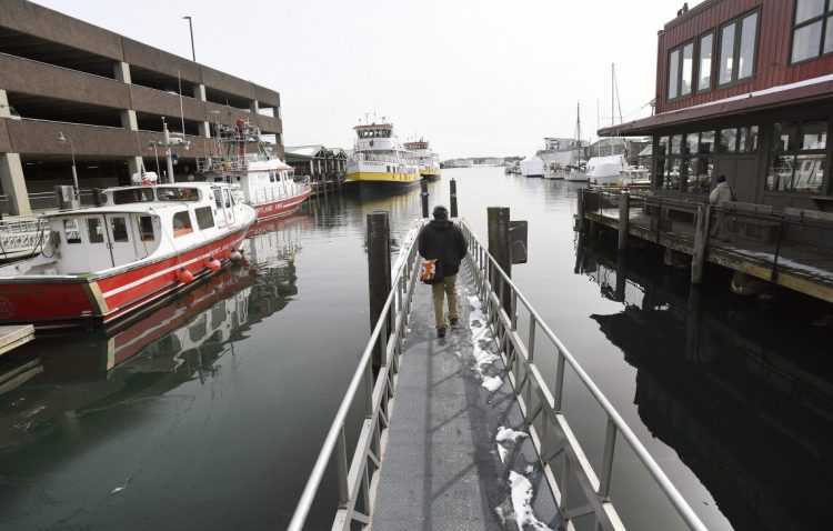
Portland Harbor was icy and calm late Wednesday morning, resting in the cold quiet that often precedes winter storms.
Still, the power of a king tide was evident along the centuries-old wharves that line Commercial Street at the mouth of the Fore River.
Under the amplified influence of a super moon aligned with the sun, the 11-foot-6-inch extreme high tide nearly brimmed many piers and pushed floats even with a newly refurbished Portland Wharf. Flood stage is 11 feet, 8 inches, with average high tides ranging from 8 to 10 feet.
Rick Frantz was there to photograph the 11:18 a.m. event as a volunteer in a new effort by Friends of Casco Bay to predict future impacts of sea-level rise on one of Maine’s richest natural resources.
Frantz, who owns Andy’s Old Port Pub, has seen some of Portland’s wharves so flooded that they were closed to traffic, waves of sea water gushing where people usually walk and drive.
“This isn’t as high as I’ve seen it recently,” Frantz said Wednesday, trudging along the waterfront, cell phone in hand. “You get a storm surge and those floats are going to be rising above the piers.”
Frantz is among a growing contingent of volunteers who are using their smart phones to monitor the health of Casco Bay with a free Water Reporter app available on the nonprofit organization’s website.
Launched last summer, the app allows volunteers to upload photos and describe conditions they observe around the bay related to water pollution, acidification, algae blooms, trash, erosion, marine wildlife and now, sea-level rise.
Rick Frantz observes a high tide Wednesday in Portland between Maine Wharf, left, and Custom House Wharf. “This isn’t as high as I’ve seen it recently,” he said. Staff photo by Shawn Patrick Ouellette
More than 80 people have downloaded the app since August and more than 30 volunteers uploaded photos and observations of Wednesday’s king tide, said Sarah Lyman, the group’s community engagement coordinator.
“People are carrying around these devices that can really help us out,” Lyman said. “We’re able to use the data in really significant ways as we work with other scientists and advocates.”
Based on the latest tidal trends, the National Oceanic and Atmospheric Administration predicts that by the year 2100, Commercial Street and other areas that rim Casco Bay will be under at least a foot of seawater at high tide on a calm day. Add some wind and weather and accelerated glacial melting, and sea level in the bay could rise 6 to 10 feet in the same period.
“The bay is changing quickly,” Lyman said. “In a few years, will it look really different? That’s what we hope to answer over time.”
Lyman said the app also will help people better understand their role in what’s happening in and around the bay, which is key to saving it from further degradation by human use and climate change.
“Portland wouldn’t be Portland without the bay,” Lyman said. “It’s really important for more folks to be connected to the bay because it’s going to take us working together to protect it.”
High tide in Portland on Wednesday looking toward Custom House Wharf. Staff photo by Shawn Patrick Ouellette
King tides are the very highest tides of the year. They are predictable and occur naturally, when the sun and moon are aligned and closest to the earth, augmenting their gravitational forces.
As sea level rises, king tides are expected to become more frequent and noticeable and have greater impacts, including storm surges that flood low-lying areas and push further inland, eroding shorelines, damaging coastal properties and tearing apart roads, bridges and other public infrastructure.
Friends of Casco Bay staffers noted two of many bills now before the Legislature that would address aspects of climate change and sea-level rise. Supporters anticipate a warmer reception under newly elected Gov. Janet Mills, a Democrat who has pledged to address climate change issues that were ignored by the Republican administration of former Gov. Paul LePage.
L.D. 565 would establish the Maine Coastal Risks and Hazards Commission to help Maine communities plan for the infrastructure impacts of sea-level rise. L.D. 510 would create a science and policy advisory council to address the impacts of climate change on Maine’s marine species.
“There is an excitement and an optimism around the effort to address climate change,” said Ivy Frignoca, baykeeper for Friends of Casco Bay.
While the exact cost of operating either panel hasn’t been outlined in the bills, “it will be minimal compared to the cost of losing a fishery like lobstering or clamming,” Frignoca said.
Rick Frantz, a volunteer with Friends of Casco Bay, photographs high tide from Portland Pier on Wednesday. Frantz is among a growing number of volunteers who are using their smartphones to monitor the health of Casco Bay. Staff photo by Shawn Patrick Ouellette
The threat to local fisheries is just one worry that plagues Rick Frantz as he’s taking photos of extreme high tides on Portland’s waterfront. It’s a task he takes personally because he lives and works at the edge of Casco Bay. His house on Great Diamond Island overlooks the water.
“I’ve been living out on the bay for 19 years,” Frantz said. “What I’ve seen in erosion in recent years is incredible. The health of the bay and the livelihoods of most of my friends depend on us taking action now.”
Kelley Bouchard can be contacted at 791-6328 or at:
kbouchard@pressherald.com
Twitter: KelleyBouchard
Send questions/comments to the editors.

Success. Please wait for the page to reload. If the page does not reload within 5 seconds, please refresh the page.
Enter your email and password to access comments.
Hi, to comment on stories you must . This profile is in addition to your subscription and website login.
Already have a commenting profile? .
Invalid username/password.
Please check your email to confirm and complete your registration.
Only subscribers are eligible to post comments. Please subscribe or login first for digital access. Here’s why.
Use the form below to reset your password. When you've submitted your account email, we will send an email with a reset code.