


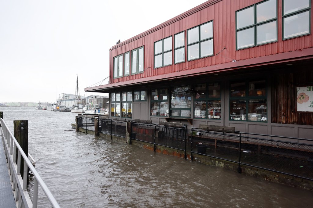

Jennie Plummer was inside Brady’s Restaurant in Boothbay Harbor Wednesday morning when the water started rushing in. It receded, then came back even stronger.
“We had this little tsunami. I had to try to jump on the bar. It was wild,” said Plummer, who owns the restaurant. By noon, when they normally open, a dozen volunteers had showed up to start cleaning up water, seaweed and other debris carried in by the waves.
She estimated the damage could total $10,000 to $12,000, but said friends and neighbors helped save some equipment and she hopes to reopen Thursday.
“I’ve never seen what I saw this morning,” said Plummer, who has owned the restaurant for six years and lived in the area her entire life. “It was just really bizarre.”
A powerful storm pummeled the state overnight and early Wednesday with strong wind gusts and driving rain that caused flooding in coastal areas and forced officials to close roads and beaches. It knocked out power to tens of thousands of customers.
But by midday, the sun was out in many areas as people were left to clean up the damage as floodwaters retreat.
In Kennebunkport, Celine Pochebit and her husband spent the late morning using rakes and shovels to clear away the rocks and debris left behind by a high tide that sent waves spilling across the road and into their neighborhood. Ocean Avenue was still covered with rocks and impassable early Wednesday afternoon.
It’s only the second time in nearly 20 years they’ve seen that kind of powerful high tide at their home just across the street from Walker’s Point.
“It was crazy,” Pochebit said. “The road is a disaster out there.”
Susan Shannon sweeps water out of her store, Sea Glass Jewelry Studio, in Kennebunkport on Wednesday. Gregory Rec/Staff Photographer
Susan Shannon said she had to clear out 7 ½ inches of water in her store, Sea Glass Jewelry Studio, in Kennebunkport. Shannon has been in that space since 2006 and says Wednesday’s flooding from the Kennebunk River is the worst she has ever seen.
Forecasters warned that the dynamic and unpredictable storm could cause power outages and flooding across much of the state as well as deliver as much as a foot of snow in higher elevations. Hurricane-force winds were recorded overnight off the coast of Knox County. As many as 65,000 homes and businesses were without power at the height of outages Wednesday.
Concerns about flooding increased through the morning and a flash flood warning for coastal areas in Cumberland and York counties was issued by the National Weather Service and expired around noon. A flash flood warning means that flooding is imminent or already happening.
“People need to stay away from the beaches,” Scarborough fire Chief Rick Kindelan said. Roads around Higgins Beach and Pine Point were already under water as the tide came in.
The weather service warned that the 1 ½ to 2 ½ inches of rain that had fallen would combine with tidal water and snowmelt to cause flash flooding of creeks, streams, highways, streets and low-lying areas. The weather service warned that Interstate 95 between mile markers 45 and 51 and Interstate 295 between mile markers 1 and 10 could experience flash flooding.
A house on Ocean Avenue in Kennebunkport is pummeled by a wave shortly after high tide Wednesday morning. Gregory Rec/Staff Photographer
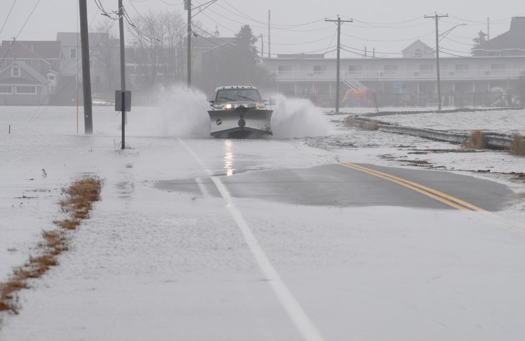
By midmorning, emergency crews were closing flooded roads throughout Greater Portland. High tide was at 9:30 a.m. and the storm surge reached just over 3 feet. In Portland, piers were underwater, cars were stranded in flood waters on Somerset Street, and other roads near the waterfront were at least partially flooded.
Water from the Scarborough Marsh covered Route 1, which was closed to traffic for much of the day.
COASTAL FLOODING
The storm swept across the Northeast early Wednesday as people in many areas were still digging out from a nor’easter that dumped more than a foot of snow last weekend. The same weather system brought heavy rain, hail and at least three tornadoes to the southern states on Tuesday before it moved eastward.
Much of the snow that fell in southern Maine on Sunday – more than 18 inches in some places – melted, increasing the potential for flooding in streams and urban areas with poor drainage or storm drains clogged with snow.
A Portland city worker erects a barricade at the intersection of Franklin Avenue and Somerset Street, where two vehicles were stranded by flooding on Wednesday. Ben McCanna/Staff Photographer
The heavy rain and wind brought down trees and power lines and caused scattered closures on southern Maine roads.
In Scarborough, public safety officials asked people to stay off the roads and away from the water. Highland Avenue was impassable because of downed trees and power lines. Ocean Avenue was closed at Higgins Beach. Pine Point Road near The Clambake restaurant was underwater. Route 1 over the marsh was closed as tide waters continue to rise.
“People should stay off the roads anywhere in town until first responders and utility crews get out to make repairs,” Kindelan, the fire chief, said.
Wells police said a woman’s car had gotten stuck while driving over flooding debris Wednesday morning, and another driver with a truck helped push her out. Police closed Webhannet Drive from Seaview Drive to Days Lane because of splash over from the incoming tide. Mile Road was under water and closed to traffic.
Sawyer Road at the Scarborough-Cape Elizabeth line was closed Wednesday afternoon after a car was swept out into the marsh.
Around 9:40 a.m., the driver called 911 and said they were stuck after trying to drive through standing water. Emergency responders from Cape Elizabeth and Scarborough helped extract the person using an inflatable boat.
Cape Elizabeth Fire-Rescue said Wednesday afternoon that it was still waiting for the tide to go out so they could retrieve the car.
In Westbrook, Larrabee Road had been partially closed since 3 a.m. because of downed power lines. Cumberland police said some roads were covered by standing water.
Several roads in Portland were flooded, included Somerset Street near Whole Foods, where three cars were stranded in the water, said Sean Donaghue, spokesman for the Portland Fire Department.
“That is a typical area that gets flooded frequently and the high tide at 9:30 definitely pushed up the amount of flooding we had,” said Jessica Grondin, a spokesperson for the city.
There was also flooding at the Portland Pier and along Commercial Street, as well as outer Congress Street near the Fore River, and the area around Elm and Lancaster streets, Grondin said.
A police officer comforts a crash victim, far left, as a utility truck lies on its side in floodwaters after driving through a guardrail on I-295 northbound, falling over an embankment and landing on a walking trail alongside Tukey’s Bridge on Wednesday. Ben McCanna/Staff Photographer
In what was perhaps the most dramatic moment of the day, a commercial truck drove off Tukey’s Bridge in Portland and landed in the water Wednesday morning. Three people were removed from the water and taken to a local hospital with minor injuries, a spokesman for the fire department said.
Curtis Trimmer, an employee at the Portland Water District, said he was watching the floodwaters when he heard a loud noise and a truck “came flying over the railing.”
“It kind of did a nosedive onto the trail and ended up in the water,” he said. “After that we rushed down to make sure the guys were OK.”
POWER OUTAGES
More than 50,000 homes and businesses across the state were without power by 8:30 a.m. and that number climbed to nearly 65,000 by 11 a.m. By then, the worst of the storm was over and conditions improved throughout the day as crews worked to restore power and clear fallen trees.
Central Maine Power reported more than 42,000 customers without power at 8:30 a.m., but that dropped to 18,000 by 1 p.m. Most of Cumberland County’s were in Harpswell, Scarborough and other coastal towns.
In York County, more than 9,000 customers started the day without power, but more than 4,000 customers were restored by late morning. Kennebunkport and York were hardest hit by early outages, according to CMP. More than 9,000 were reported in Lincoln County early Wednesday, but the number dropped to 5,700 by midday.
CMP spokesman Jon Breed in a message posted on CMP’s website said that it expects to have restored power to 90% of its customers by Wednesday evening. As of 9:30 p.m., more than 5,000 CMP customers had no power, with most of the affected customers in Kennebec County.
Breed explained that some restoration efforts were being hindered by extreme flooding that prevented crews from entering affected areas. In those areas where flooding was severe, power may not be restored until noon on Thursday.
Lincoln County was hit particularly hard by the storm. Bristol Fire Chief Scott Sutter described the damage in his coastal community as “devastating.”
Sutter said a seasonal home, docks and buildings located in the village of New Harbor were swept into the ocean by waves from Wednesday’s storm.
“The waves were just huge today. Houses got pushed off their foundations and propane tanks were floating in the water. The damage was devastating,” Sutter said, adding that no one was injured.
Sutter said a building located on the grounds of the historic Pemaquid Point Lighthouse in Bristol was destroyed after waves washed away the brick foundation walls of the bell house. There does not appear to be any damage to the lighthouse. The Pemaquid Point Lighthouse Park is run and maintained by the Bristol Parks and Recreation Department. The Lighthouse Tower is maintained by Friends of Pemaquid Point Lighthouse.
“I haven’t seen a storm like this come up so fast and so strong,” said Kyle Santheson, an amateur photographer who lives in Waldoboro. Santheson shared images that he took of the storm damage in Bristol. Santheson said the waves breaking at Pemaquid Point were more than 20 feet high.
Crews work on Highland Avenue in Scarborough after power lines were downed by a large, fallen tree. Derek Davis/Staff Photographer
CMP officials have been monitoring the storm since last week and began staging extra line and tree crews across its coverage area Tuesday night, a spokesperson said.
“Our crews are working with local emergency management agencies to clear blocked roads and make downed power lines safe after a strong storm entered our service area overnight. As the weather clears out of our region, we are restoring power as quickly and safely as possible,” CMP officials said in a social media post Wednesday morning.
Versant, which covers northern and eastern Maine, reported nearly 14,000 outages at 10 a.m. and that number jumped sharply to more than 31,000 an hour later. Hardest hit areas included far Down East towns along the coast. The company reported about 19,000 outages at 1 p.m.
About 5,600 customers served by Versant Power were still without power as of 9:30 p.m. Wednesday, according to its outage website.
HIGH WIND WARNINGS
The storm brought widely varying weather conditions in different parts of the state.
Early snow totals included 14.7 inches in New Vineyard, 14.6 inches in Madrid, 14 inches in Carrabassett Valley, 10 inches in Rangeley, 8½ inches in Otisfield and 7½ inches in Livermore Falls.
In Raymond, the rain fell so hard overnight that it knocked a wall of snow off the roof of Paris Farmers Union. The snow slid and broke a propane line, which went into one of the building’s heating units on its roof and caused an explosion, Fire and Rescue Chief Bruce Tupper said.
Firefighters were called to the area shortly before 5 a.m. They couldn’t see it at first because of a roof covering, Tupper said, but they could smell the propane. After some searching, they noticed flames 3 feet high from the back of the building.
“That was pretty down and dirty and simple, once we found it,” Tupper said.
By 8 a.m., the fire was cleared. The only damage he knew of was that the store will have to replace its propane lines.
“It could’ve been so much more of a disaster, really.”
Firefighters inspect a smoldering utility pole on a flooded Portland Pier at high tide Wednesday. Ben McCanna/Staff Photographer
A high-wind warning remained in effect through 1 p.m. Wednesday for coastal areas.
Wind gusts reached 95 mph at Isle au Haut off the coast of Knox County, equal to that of a strong Category 1 hurricane.
Other recorded wind gusts included 63 mph at the Portland International Jetport, 53 mph in Wiscasset, 51 mph in Augusta, 47 mph in Boothbay and 73 mph in Rangeley, the weather service said.
Megan Arsenault, deputy director of the York County Emergency Management Agency, said as winds started to diminish, the agency wasn’t receiving reports of significant widespread damage.
“Things are a little bit better than we planned for, which is always a good thing,” she said.
STORM CAUSES DELAYS
School districts across southern and Midcoast Maine called for delayed openings or remote learning days.
State offices opened at noon Wednesday to allow Maine Department of Transportation crews time to clear roads. State officials urged Mainers to use caution during the storm.
The Portland International Jetport reported several delayed flights Wednesday morning, but most flights appeared to be on schedule.
High winds pushed a Southwest Airlines Boeing 737MAX8 aircraft into a jet bridge around 4:35 a.m., according to jetport officials. There were no passengers or crew on the plane at the time. Southwest is sending an additional aircraft to the jetport to accommodate passengers.
Amtrak Downeaster trains 680 and 681 were canceled on Wednesday. Some stations were without power.
Staff Writer Dennis Hoey contributed to this report, which also contains material from The Associated Press.
Copy the Story LinkSend questions/comments to the editors.

Success. Please wait for the page to reload. If the page does not reload within 5 seconds, please refresh the page.
Enter your email and password to access comments.
Hi, to comment on stories you must . This profile is in addition to your subscription and website login.
Already have a commenting profile? .
Invalid username/password.
Please check your email to confirm and complete your registration.
Only subscribers are eligible to post comments. Please subscribe or login first for digital access. Here’s why.
Use the form below to reset your password. When you've submitted your account email, we will send an email with a reset code.