


Portland Harbor and a parking lot between Chandler’s Wharf and Widgery Wharf in Portland are nearly indistinguishable at high tide Wednesday. Ben McCanna/Staff Photographer
Another winter storm could bring record-high water to Portland and cause significant flooding in coastal areas that already were battered by high winds and flooding this week.
Beginning Friday night, the storm is predicted to bring 1 to 1.5 inches of rain along the coast and drop 3 to 4 inches of snow in the interior. Derek Schroeter, a meteorologist with the National Weather Service in Gray, said the foothills can expect 6 to 8 inches of snow, while the mountains could get up to a foot.
“Our No. 1 concern with this storm is we are looking at onshore winds that are going to produce a significant storm surge that unfortunately will coincide with tomorrow’s high tide cycle,” Schroeter said on Friday. “Because of the significant coastal impact we saw with the last storm, a lot of infrastructure was compromised. That makes coastal areas that much more vulnerable to potential water levels tomorrow.”
Wednesday’s storm caused extensive damage and knocked out power to tens of thousands of customers across the state. Officials are warning people to stay away from the coast on Saturday.
The weather service has issued a coastal flood warning from 9 a.m. to 4 p.m. Saturday for coastal York, Cumberland, Sagadahoc, Lincoln, Knox and Waldo counties. Wind advisories and warnings are in effect for the entire Maine coast from 4 a.m. to 4 p.m.
The peak storm surge is expected to reach 2.5 to 3 feet on Saturday and will coincide with the highest tides of the winter season.
The water level in Portland Harbor on Saturday is forecasted to reach 14.3 feet, which would be the highest since recordkeeping began in 1912, Schroeter said. The water level during Wednesday’s storm, which caused flooding along the waterfront and in low-lying areas, was 13.84 feet.
However, Portland Harbor Master Kevin Battle doesn’t believe the storm will be as bad as the one that hit on Wednesday, nor does he see indications of a “massive storm surge.”
“We’ll know for sure Sunday,” he said. “There are no indicators it will be an atrocious storm. The storm could go this way, it could go that way.”
Will Owen, president of the Maine Harbor Masters Association, said in an email Friday night that the organization is working with the Maine Coast Fishermen’s Association and state Department of Marine Resources to encourage those who are affected by the storm to report damage to harbor masters and municipalities. Town and city officials will contact county emergency management agencies.
The Maine Coast Fishermen’s Association said it will help gather information, including photos and descriptions, about storm damage to working waterfront properties in an effort to seek opportunities for federal funding.
“Also, important to note, it does not matter whether or not the properties were insured,” Monique Coombs, director of community programs at the Maine Coast Fishermen’s Association, told harbor masters in an email. “I imagine many of them weren’t.”
The storm will produce strong winds, but is unlikely to reach the levels seen on Wednesday, when hurricane-force winds were recorded off the coast. Along the southern coast, peak winds will approach 50 mph, Schroeter said. The Midcoast is predicted to see peak winds of 60 mph, with higher gusts over the water and islands and Down East.
The National Weather Service will update its forecast at 4 a.m. Saturday, he said.
SERIOUS COASTAL FLOODING EXPECTED
State officials said the storm could cause some coastal areas to flood for the first time.
“High tides, heavy surf and windswept waves could make the coast extremely dangerous. For their safety we urge citizens to stay away from the coastline during this significant storm,” said Peter Rogers, director of the Maine Emergency Management Agency. “Coastal residents need to make plans now for flooding, possible road closures, and always follow guidance from local officials.”
“I strongly urge Maine people, particularly those along the coast, to take this storm seriously, to prepare for it, and to follow the advice of local emergency management officials,” Gov. Janet Mills said in a prepared statement Friday. “We are encouraging people to stay away from the coast if possible. While the storm surge will likely be smaller than earlier this week, we are expecting a larger swing in the tides, which means that folks should expect serious flooding again. With high winds, there is also the likelihood of power outages.”
“MEMA’s Emergency Operations Center will be at full activation tomorrow, and we will continue to monitor the storm’s impacts and respond accordingly. Please do your part by preparing and taking precautions to stay safe. Remember, it is never safe to walk through flowing water, drive through flooded areas, or drive around road barriers.”
Portland officials issued a warning to residents that the storm could bring 1 to 2 feet of inundation and potentially cause more flooding than Wednesday. High tide in Portland is at 12:05 p.m.
“City crews will be monitoring any flooded streets and will post barricades when necessary,” city spokesperson Jessica Grondin said. “We urge the public to adhere to these barricades and not drive through flood water.”
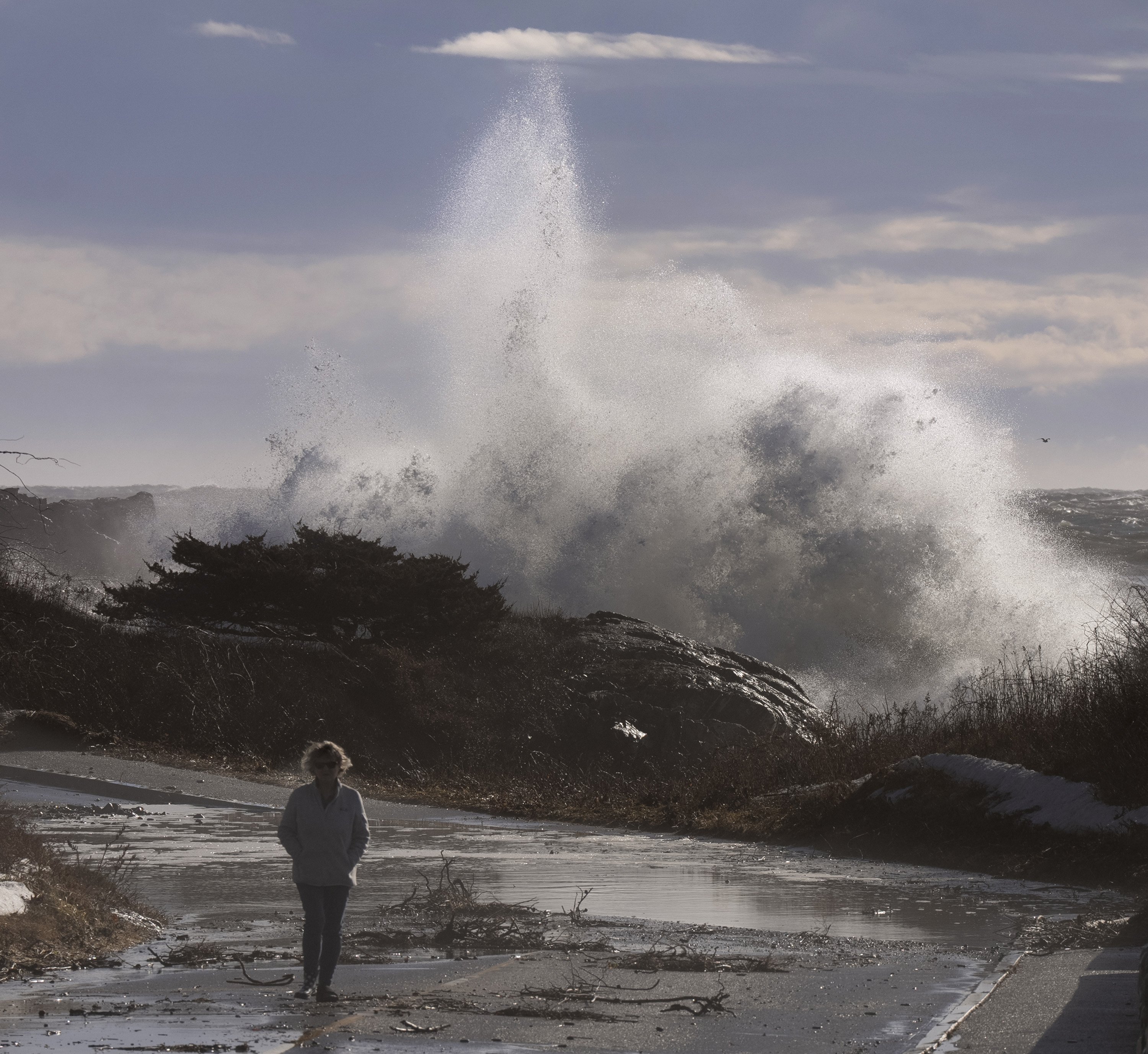
A wave crashes over rocks behind a woman walking along Ocean Avenue in Kennebunkport on Wednesday. Gregory Rec/Staff Photographer
In York County, county emergency management officials are preparing for major coastal flooding that could cause numerous road closures and may inundate low-lying property. Areas that lost dunes or other flood protection mechanisms on Wednesday will be particularly vulnerable during the storm, said Megan Arsenault, deputy director of York County Emergency Management Agency.
“We are urging individuals to avoid traveling to the coast this weekend,” she said. “Municipal officials are actively cleaning up from Wednesday’s storm damages and this weekend’s hazards could post a serious threat to life and safety.”
Clif Whitten, deputy fire chief in Old Orchard Beach, said it is crucial that people adhere to road closures.
“Do not attempt to cross barricades without consulting authorities first. Disregarding these precautions not only endangers your safety, but also puts the lives of first responders at risk,” he said.
Scarborough officials announced Friday that several coastal roads will be closed Saturday because of anticipated flooding. Roads closed starting at 8 a.m. include Black Point Road at the Black Point Inn, Sawyer Street from Spurwink Road to the Cape Elizabeth line and Ocean Avenue at Spurwink Road.
Road closures are expected on Route 1 at the marsh, Payne Road between Route 1 and Beech Ridge Road, Pine Point Road at the Nature Center and by the Clambake Restaurant, and Black Point Road between Eastern Road and Highland Avenue.
Staff Writer Stephen Singer contributed to this report.
Copy the Story LinkSend questions/comments to the editors.

Success. Please wait for the page to reload. If the page does not reload within 5 seconds, please refresh the page.
Enter your email and password to access comments.
Hi, to comment on stories you must . This profile is in addition to your subscription and website login.
Already have a commenting profile? .
Invalid username/password.
Please check your email to confirm and complete your registration.
Only subscribers are eligible to post comments. Please subscribe or login first for digital access. Here’s why.
Use the form below to reset your password. When you've submitted your account email, we will send an email with a reset code.